
View looking west over one of the barrows of the Cobdale group.
This is a group
of eight, possibly nine round
barrows on a plateau of land just to the north of Cobdale Cottage
towards the western edge of the Yorkshire Wolds. Many have been badly
damaged due to being under cultivation for a long period but at least
one is clearly visible to the east of Cobdale Lane and is shown in the
picture above.
Eight of the barrows were excavated by JR Mortimer in 1882 (numbered 244, 246, 247, 248, 249, 250, 251, 264 in Mortimer 1905) however he noted that several of them had already been dug into by a Mr. J. Silburn in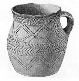 the middle of the 18th
century as well as various tenants who had farmed the land. Despite this
Mortimer was able to recover and document many finds from the barrows
which contained a mixture of inhumations
and cremations, one burial was apparently in a wickerwork coffin covered
over by a wooden roof, another burial was also beneath a wooden roofed
structure while two other burials seem to have been in graves lined with
wooden panels. One set of cremation remains was found within an inverted
collared urn
with another urn filled with burnt bone noted as having been recovered
the previous year but the rest of the cremations appear not to have been
placed in containers although bone and bronze
pins found within the barrows could have been used used to tie hide bags
containing cremation remains. As well as urns Mortimer also recorded several
food
vessels and small incense
or 'accessory' cups as well as an unusual handled beaker
(see inset image) that accompanied the burial of a child plus sherds
from several other pottery vessels. Flint
fragments, a flint knife, a barbed and tanged arrowhead and the broken
end of a stone axe were also found during the excavations.
the middle of the 18th
century as well as various tenants who had farmed the land. Despite this
Mortimer was able to recover and document many finds from the barrows
which contained a mixture of inhumations
and cremations, one burial was apparently in a wickerwork coffin covered
over by a wooden roof, another burial was also beneath a wooden roofed
structure while two other burials seem to have been in graves lined with
wooden panels. One set of cremation remains was found within an inverted
collared urn
with another urn filled with burnt bone noted as having been recovered
the previous year but the rest of the cremations appear not to have been
placed in containers although bone and bronze
pins found within the barrows could have been used used to tie hide bags
containing cremation remains. As well as urns Mortimer also recorded several
food
vessels and small incense
or 'accessory' cups as well as an unusual handled beaker
(see inset image) that accompanied the burial of a child plus sherds
from several other pottery vessels. Flint
fragments, a flint knife, a barbed and tanged arrowhead and the broken
end of a stone axe were also found during the excavations.
Sadly little remains to be seen at the site today with most of the barrows badly damaged by ploughing, English Heritage record them as having been between 20-35 metres in diameter, the image above is probably barrow number No 21110 at SE85885392 which measures about a metre and a half high, the rest of what remains all being under a metre in height.
Date: Bronze Age
Eight of the barrows were excavated by JR Mortimer in 1882 (numbered 244, 246, 247, 248, 249, 250, 251, 264 in Mortimer 1905) however he noted that several of them had already been dug into by a Mr. J. Silburn in
the middle of the 18th
century as well as various tenants who had farmed the land. Despite this
Mortimer was able to recover and document many finds from the barrows
which contained a mixture of inhumations
and cremations, one burial was apparently in a wickerwork coffin covered
over by a wooden roof, another burial was also beneath a wooden roofed
structure while two other burials seem to have been in graves lined with
wooden panels. One set of cremation remains was found within an inverted
collared urn
with another urn filled with burnt bone noted as having been recovered
the previous year but the rest of the cremations appear not to have been
placed in containers although bone and bronze
pins found within the barrows could have been used used to tie hide bags
containing cremation remains. As well as urns Mortimer also recorded several
food
vessels and small incense
or 'accessory' cups as well as an unusual handled beaker
(see inset image) that accompanied the burial of a child plus sherds
from several other pottery vessels. Flint
fragments, a flint knife, a barbed and tanged arrowhead and the broken
end of a stone axe were also found during the excavations.Sadly little remains to be seen at the site today with most of the barrows badly damaged by ploughing, English Heritage record them as having been between 20-35 metres in diameter, the image above is probably barrow number No 21110 at SE85885392 which measures about a metre and a half high, the rest of what remains all being under a metre in height.
Date: Bronze Age
References:
Mortimer, J.R. 1905. Forty Years Researches in British and Saxon Burial Mounds of East Yorkshire. London: Brown & Sons.
Pastscape: 61747, 61766, 61769, NMR Numbers: SE 85 SE 1, SE 85 SE 8, SE 85 SE 9.
Record of Scheduled Monuments: 21109, 21110, 21111, 21112, 21113, 21114.
Stoertz, C. 1997. Ancient Landscapes of the Yorkshire Wolds. Aerial photographic transcription and analysis. RCHME.