Kes Tor Round Pound
Bronze Age / Iron Age Settlement Site
Northeast of Batworthy, Dartmoor, Devon  OS Map Ref SX66398685
OS Maps - Landranger 191 (Okehampton & North Dartmoor), Explorer OL28 (Dartmoor)


Kes Tor Round Pound - central hut
The central hut of Kes Tor Round Pound - looking west over the Teign valley.

On either side of the minor road that leads from Teigncombe to Batworthy lay the remains of a Bronze Age settlement and farming area consisting of stone lined field systems known locally as reaves, droveways and huts.

Most of the huts are fairly small, measuring between 7-11 metres in diameter, although one in particular is a little different. Kes Tor

ound Pound consists of a central stone hut with a double skin wall about a metre thick and 11 metres diameter with evidence of post holes that would have held wooden poles supporting a thatched roof - there was an entrance towards the south. What sets this hut apart is that it has an outer pound wall of about 33 metres diameter and between 1-2 metres thick, this time with an entrance to the west - there is evidence of a possible lintel over the entrance.

Excavations within the hut in 1952 uncovered broken pottery and flints, hammer stones, a spindle whorl and an anvil along with a pair of pits that were used for iron smelting. It is these pits that have lead to some confusion as the the date of the Round Pound. While the site and surrounding field systems are believed to date from the Bronze Age, traces of iron ore would suggest a later Iron Age date for this building, so is this a site that was in continuous use over a long period of time, was it abandoned at an earlier date and later reused for metal working or was it indeed built during the Iron Age? To further confuse matters the site was re-utilised during the Medieval period when the pound was divided by low internal walls and some kind of shelter built - the stone being robbed from the earlier walls.

Kes Tor Round Pound - pound wall
The outer wall of the pound is to the right of the picture with the hut the circular structure to the left.
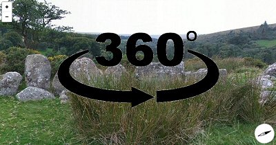
360 Degree Panorama
360 Degree Panorama

Back to Map
| Home | Full Glossary | Links | Email: chriscollyer@stone-circles.org.uk