
Looking north to Mam Tor. The line of defences can be seen as the narrow light band below the summit.
The first evidence of prehistoric use of the hill comes from the Bronze Age but it must have been a significant place to people long before that - indeed a polished stone axe and flints from the Neolithic had been found here. The earliest Bronze Age remains at the site consist of two round barrows near the top of the hill - one actually has a trig point that records the height as 517 metres above sea level. This particular barrow is quite low and is now cobbled to protect it from damage but the other barrow to the southwest is quite well preserved despite having a large crater-like hole in its top. Both barrows have fine views to the north, south and west.
During the later Bronze Age and continuing into the Iron Age the hill was occupied as a ''slight univallate hillfort'' which is defined as a small hilltop enclosure consisting of a single line of defenses. Mam Tor fits this description in that its earthwork is a single rampart, a berm, a ditch and an outer bank that enclose an area of about 6 hectares near the top of the hill. It is thought that the rampart was originally built as a wooden palisade cut into the hillside before being replaced by a more sturdy stone defence that could have been as much as 3 metres high and 5.5 metres wide on the eastern side. Next there is a flat terrace (or berm) then a U shaped ditch which is now silted up but which could have been up to 2 metres deep and about 2.5 metres wide. Finally a small outer bank would have been around 1 metre high and 2 metres wide. The site was entered by interned entrances to the north and the southwest, this second one being better preserved and shown in the image below. Within the internal area of the enclosure, and on either side of the main ridge of the hill, were found the remains over seventy hut platforms which were built by first cutting a level surface into the side of the hill before constructing turf or stone walls and internal hearths and pits. Excavations around and inside these huts revealed much broken pottery as well as whetstones and shale beads.

The southwest entrance to the hillfort.

Inner bank, berm and silted ditch on the south side.

Defences on the western side of the hill.

The barrow near the southwest entrance.

Satellite view of Mam Tor. The black dashed line shows the inner rampart with the outer defenses being visible along the western side while the sheer scale of the earthwork can be judged from the size of the road snaking across the lower left of the picture. The area of landslides across the southeastern edge of the hill which gives it its distinctive profile are also clearly visible.
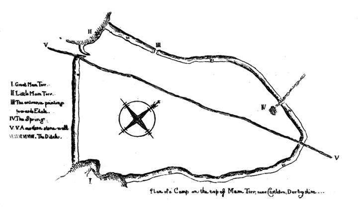
The antiquarian view - drawing of the earthworks of Mam Tor taken from 'Sketch of a Tour into Derbyshire and Yorkshire' published in 1783 by William Bray. It is interesting to note that even over 200 years ago the hillside was subject to landslides (shown as the area marked 'I' on the lower left).