The circle has a diameter of around 13 metres with the bank extending another 2 metres beyond while within the circle are the remains of a cairn, outside the circle are what may be outliers or part of an avenue - it is reported that there are two or three stones in a line to the northwest and a further two to the south of the circle.
A word of warning when visiting this site - although it is close to Chatsworth house, do not be tempted to drive down the track that leads east from Beeley Lodge over Beeley hilltop - it is barley suited for vehicles. Approach from the east instead and park beside Hell Bank plantation and walk the rest of the way. Partway down the track is a gate that leads onto the moor. Follow the pathway for around 400-500 metres and somewhere off to the right you should see the circle.

Leaning stone on the southwestern side of the circle.

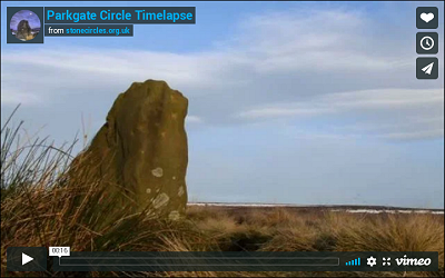
Parkgate is a circle of small stones, some shorter than the surrounding grass. This picture taken in 2000 shows how difficult it can be to see the circle above the vegetation even in winter.