 View of the eastern chamber of Trefignath - looking north. |
|
At first sight the remains of
this Neolithic
chambered
cairn are a confusing
jumble of flat slabs and scattered boulders
and indeed the original
layout of the monument was not fully understood
until it was excavated between 1977-1979, interpretation of the site not being made any easier by the removal of many of the stones sometime towards the end of the 18th century. Evidence of hearths, flint tools
and pottery found beneath the stones suggest the area was being used in the period
between 4000BC-3600BC as a settlement site prior to the building of the first monument of a multi-phase burial tomb
probably very shortly afterwards. 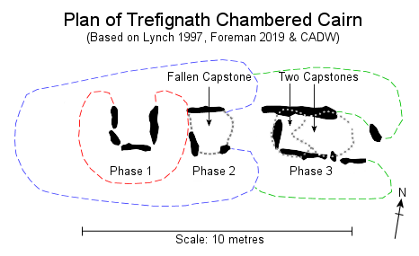 The first phase of construction at what is
now the western end of the monument was a simple passage grave consisting of
a square tomb of stone slabs probably covered with a corbelled roof and with an entrance facing towards the north. The resulting chamber was then covered
with a circular stone cairn. The first phase of construction at what is
now the western end of the monument was a simple passage grave consisting of
a square tomb of stone slabs probably covered with a corbelled roof and with an entrance facing towards the north. The resulting chamber was then covered
with a circular stone cairn.
Perhaps several hundred years later, Phase 2 saw a larger rectangular 2.6 metre by 1.5 metre stone chamber covered with a large capstone built on the eastern side of the first tomb. This time a wedge shaped cairn was constructed which incorporated the earlier passage grave and the new monument faced with drystone walling with an eastward facing forecourt in the style of Cotswold-Severn tombs like Parc-le-Breos Cwm on the Gower Peninsula. The final phase of the monument involved the building of a further rectangular 2.5 metre by 1 metre chamber towards the east in the existing forecourt area of the Phase 2 structure thereby blocking the central chamber. The cairn was again extended to cover all three chambers and a new drystone forecourt constructed. This time however the forecourt and entrance to the chamber was slightly skewed towards the southeast. How long it took Trefignath to reach its final form is not clear but it is suggested the site may have been in use for between 1000-1200 years. The changing alignments of the chamber entrances over the lifetime of the monument are interesting. The passage grave of Phase 1 belongs to a type of monument found along the Atlantic seaboard of Europe, extending up from Portugal and western France to the east coast of Ireland and the west coast of Britain. Due to the similarities in design it is thought the British and Irish tombs may have been built by early farming communities descended from settlers from western Europe. At Trefignath the chamber is open to the north across Holyhead Bay towards the Irish Sea, is the tomb referencing the sea as a memory of where the builders ancestors came from? The two later phases shift the axis of the tomb through 90 degrees to face eastwards towards Anglesey, mainland Britain and the rising sun. Were these later builders a different group of people co-opting the sanctity of the earlier tomb or were they descendants of the same farmers who by now had embraced new beliefs and a new style of burial monument more commonly found inland to the southeast. In essence, did they now regard themselves as 'British'? Trefignath was partially reconstructed in 1980 following the excavation and it is the eastern chamber that is the most complete part of the monument with its pair of 2 metres tall portal stones (to the right of the picture at the top of this page) standing beyond the smaller upright side slabs of the tomb supporting two low capstones. The middle phase chamber remains in a collapsed state with its capstone broken while the side slabs of the earlier western passage grave were re-erected and can be seen as an open box shape of low upright stones. The various spelling of Trefignath as Trefigneth, Trevignedd, or Treseiriol may derive from 'Tre' meaning place and 'Mign' signifying grey moss or lichen on stone. |
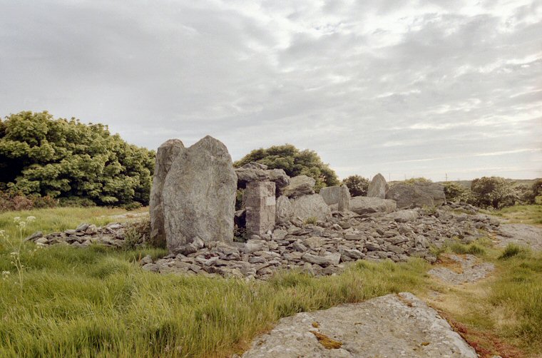 Eastern chamber - looking southwest. |
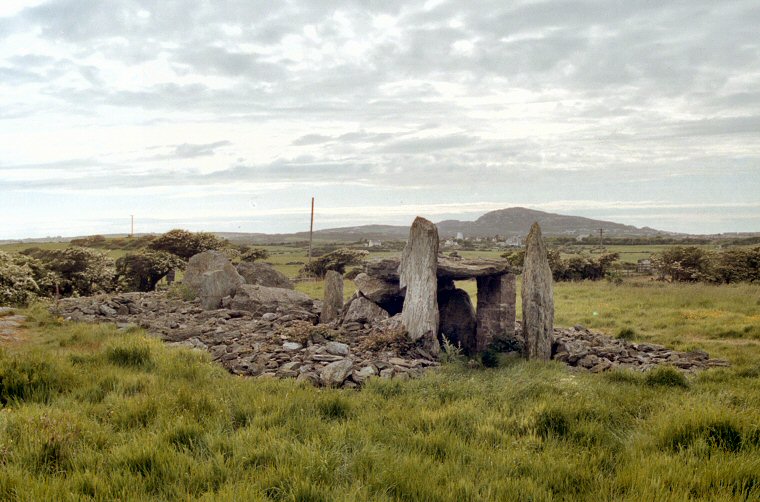 Looking northwest towards Holyhead Mountain. Looking northwest towards Holyhead Mountain. |
 A rather nice information board at Trefignath illustrates the development of this multi-phase monument. The cut-away view is looking south (the opposite direction of the black and white plan above) with the small first phase passage grave to the right with its north facing entrance. The second phase extends the monument to the east and west and it takes on a more 'Cotswold-Severn' form with a new chamber and interned forecourt to the east. The final phase extends the monument further eastward with a yet another chamber and a forecourt inclined slightly to the southeast. A rather nice information board at Trefignath illustrates the development of this multi-phase monument. The cut-away view is looking south (the opposite direction of the black and white plan above) with the small first phase passage grave to the right with its north facing entrance. The second phase extends the monument to the east and west and it takes on a more 'Cotswold-Severn' form with a new chamber and interned forecourt to the east. The final phase extends the monument further eastward with a yet another chamber and a forecourt inclined slightly to the southeast. (Copyright CADW) |
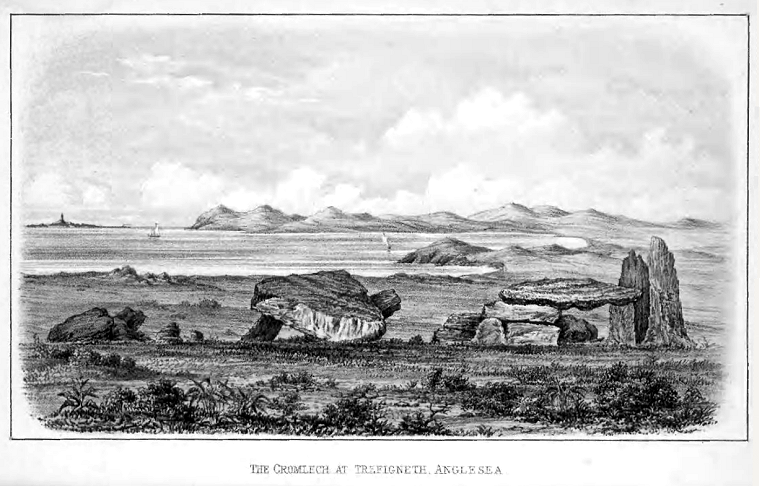
 A fine illustration of Trefignath that appears in the Archaeological Journal 1871 by W. O. Stanley, it shows the central chamber to the left with a fallen capstone and the eastern chamber with its double capstone to the right. A fine illustration of Trefignath that appears in the Archaeological Journal 1871 by W. O. Stanley, it shows the central chamber to the left with a fallen capstone and the eastern chamber with its double capstone to the right. |
 This illustration shows a wider view of Trefignath looking north over Holyhead Bay with the lighthouse of the Skerries in the distance to the left, drawn by W. O. Stanley 1874. Stanley was not only a Member of Parliament and the Lord Lieutenant of Anglesea (as it was then), he was also a Fellow of the Society of Antiquaries. How many MP's today have an archeological background or the understanding and will to preserve our ancient heritage? This illustration shows a wider view of Trefignath looking north over Holyhead Bay with the lighthouse of the Skerries in the distance to the left, drawn by W. O. Stanley 1874. Stanley was not only a Member of Parliament and the Lord Lieutenant of Anglesea (as it was then), he was also a Fellow of the Society of Antiquaries. How many MP's today have an archeological background or the understanding and will to preserve our ancient heritage? |
Site Visits / Photographs: June 2001. References: Baynes, E. N. 1911. The Megalithic Remains of Anglesey. London: Cymmrodorion Society. Burnham, A. (Ed.). 2018. The Old Stones... Megalithic Sites of Britain and Ireland. London: Watkins. Cunliffe, B. 2001. Facing the Ocean. The Atlantic and its Peoples. Oxford: Oxford University Press. Darvill, T. 2004. Long Barrows of the Cotswolds and surrounding areas. Stroud: Tempus Publishing Ltd. Darvill, T. 2010. Prehistoric Britain. 2nd Edition. Abingdon: Routledge. Dyer, J. 1981. The Penguin Guide to Prehistoric England and Wales. London: Penguin Books Ltd. Foreman, P. 2019. Colour Out of Space... Neolithic Atlantic Europe. Thesis, (PhD). Bournemouth University. Joussaume, R. 1988. Dolmens For The Dead. Megalith Building throughout the World. Book Club Associates. Lynch, F. 1997. Megalithic Tombs and Long Barrows in Britain. Princes Risborough: Shire. Pollard, J. 1997. Neolithic Britain. Princes Risborough: Shire Publications Ltd. Shee Twohig, E. 2004. Irish Megalithic Tombs. Second Edition. Princes Risborough: Shire. Stanley, W. 1874. Cromlech at Trefigneth. Archaeological Journal, Vol 31, 1-2. Way, A. 1871. The Cromlechs of Anglesey. Archaeological Journal, Vol 28, 97-108. Gwynedd Archaeological Trust. Regional Historic Environment Record Primary Reference Number (PRN) : 2500 |