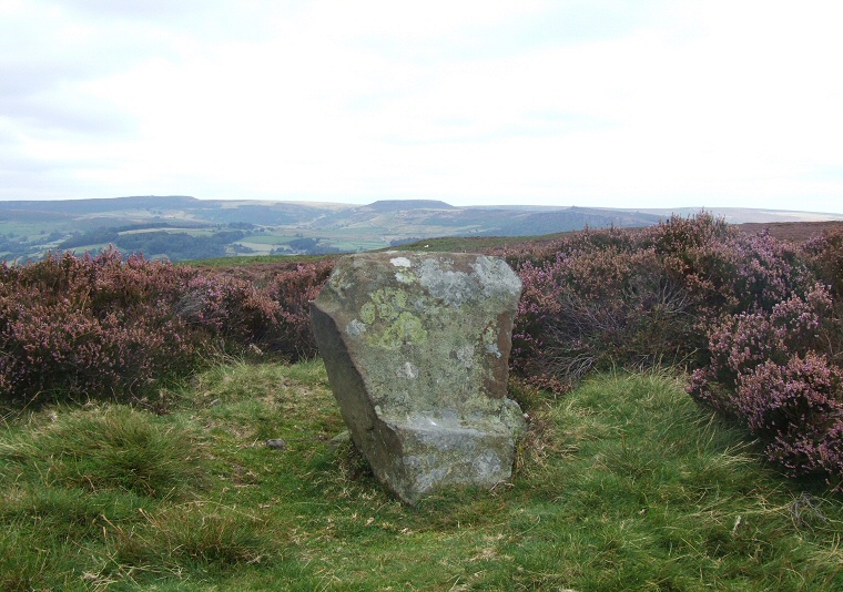
Wet Withens 'Chair Stone' looking northeast with Higger Tor on the horizon.
 It
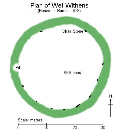
is the earth-covered stone and rubble bank that allows you to gain an understanding of the layout of Wet Withens,
it is slightly oval measuring 29-31 metres across its inner edge and extending
a further 3-4 metres beyond and stands between half a metre and a metre high, although the covering vegetation gives the illusion of it being taller. Unusually the builders do not
appear to have created any entrances through the bank, a gap or pit towards the west is of an unknown date but may be the result of stone robbing or an unrecorded antiquarian excavation while slightly lower sections towards the north, south and southeast are probably the result of old paths passing through the site.
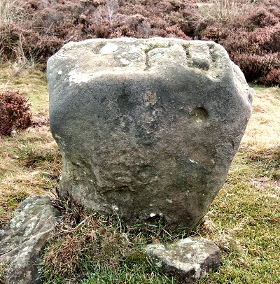
 Set within the inner edge of the bank are ten smallish gritstone blocks ranging in height from about 25cm to 70cm, all but one are leaning towards the interior of the circle to some degree, presumably pushed inwards by the settling of the bank over the millennia. The southern half of the circle is the most complete with eight stones forming an arc stretching round from the east to nearly the west while just two stones remain of the northern arc. The most prominent of the circle stones stands to the north-northeast (image at top of page and below left) and is thankfully free of vegetation, it is also the tallest stone at the site, partly due to it being the only one that is still fully upright. Its inner face has a small ledge at ground level which could either be be a natural feature or the result of part of the face being cut away so that the stone could be said to resemble a small chair. It also has a couple of possible small cup marks on its outer face although equally these could just be natural features (one of the possible cupmarks is towards the upper right of the face in the image below). What is particularly interesting is that the top of the stone bears a strikingly similar profile - a simulacrum - of the rock outcrop of Higger Tor which can be clearly seen 4.25km (about 2.6 miles) away on the horizon to the northeast (in the centre of the image above) and it is from behind Higger Tor that the Midsummer sun is seen to rise when observed from the centre of the circle.
 It has been suggested
that given the spacing between the remaining stones the original tally of the circle would have been between sixteen and eighteen, the missing
stones either carted away and broken up for building material in the 19th century or buried
beneath tumbled parts of the bank. There is also an antiquarian suggestion that there may have been a large stone at the centre
of the circle, although whether this ever existed or not is in doubt. What does exist towards
the centre however is a scatter of stones, possibly of a recent date that are surrounded by a barely discernable low cairn
said to be about 6 metres wide but no more than 20 cm high.
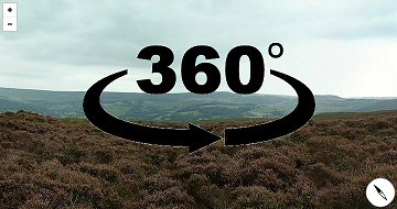
 Author and archaeologist John Barnatt of the Peak District Archaeology Service has made some interesting observations about the relationship between the stone circle and the other monuments of Eyam Moor. He points out that although a sizable cairnfield exists nearby to the east, it is set beyond a slight rise of the land between it and the circle so that the neither can be seen from each other. While some of the cairns may have had a funerary purpose it is more likely that they represent the results of prehistoric field clearance of surface rocks for the purposes of cultivation and Barnatt suggests that the circle was deliberately sited to be set apart - and out of sight - from the daily lives of the local farming community and as such was reserved for ritual activity which as we have seen above, must have included observance of the summer solstice sunrise. The location chosen by the circle builders gives some fantastic views of the wider landscape and while the higher mass of upper levels of Eyam Moor dominates the southern horizon, an arc from the northwest round to the northeast gives distant views across the Derwent Valley and towards the hills beyond (see 360 degree panorama below). Perhaps these views were important to the users of the circle to reaffirm their place in the wider prehistoric community of the East Moors at significant times of the year.
The antiquarian record:
Although there are several antiquarian accounts of the circle from the 18th and 19th century they are often rather vague and sometimes contradictory, partly due to nature of the site itself where it can be difficult to determine what constitutes a circle stone and what constitutes a large packing stone that forms part of the bank. Added to this are the differences between each author's definition of whether a stone is standing or leaning plus unverified historical accounts of various features within the circle which had already gone before the author's time, if indeed they ever existed. Here are a selection of early records:
An early account by John Wilson from sometime in the middle of the 18th century was later recorded by the Derbyshire antiquarian Thomas Bateman which describes the circle as consisting of 'sixteen stones of the large sort, set on the end, eleven or twelve of which are now standing, and the others lie near where they stood'. Wood also goes on to say that the centre of the circle contained 'a small heap of stones, now even with the ground', which fairly matches the interior of the circle as it is today.
William Wood writing in the 1840's states that the circle 'consists of sixteen oblong sandstones,standing in an upright position', he also claims that a large stone stood in the centre 'until some years back'. Whether this was just a tall tale told by locals is not clear as Wilson had previously made no mention of it, but if he was correct then it is possible that the stone may have formed part of a previously destroyed cist that may have existed within the cairn towards the centre of the circle.
The most important account of the period is probably that by Sir Gardner Wilkinson from 1860 as he also provides a basic but detailed sketch of the site (image below, drawn looking north). Wilkinson notes that 'ten stones are standing, out of fifteen or sixteen, the original number' although his plan shows many more, particularly along the southern arc which is partly hidden by the bank and it is difficult to figure out which are circle stones and which are part of the bank itself. He also mentions the cairn and the claims of a missing stone from centre of the circle 'within it what is said to be the remains of a cist. A large stone was also taken from it some years ago, which differed very much in its dimensions from those composing the circle, measuring as they do less than 3 feet in height'. It's a pity he doesn't record what the dimensions of the large stone were, but then perhaps he was just repeating the same local story recounted by Wood.
In 1870 Llewellynn Jewitt notes that 'only ten of the stones remain in situ', but his account is vague enough that it could imply that there were only ten stones remaining in total or that other stones remained on site but in a fallen state. He also adds 'in the centre a cist was discovered many years ago' but gives no further information. Fifteen years later Rooke Pennington provides another important account that records eleven stones and includes a plan of the circle and nearby Eyam Cairn (image below), the plan clearly shows that most of the stones of the northern arc were no longer in existence by that time.
By the beginning of the 20th century W. J. Andrew gives a fairly good description of the site and of the diminishing number of stones, stating that 'set in the inner margin of the mound remain ten stones of millstone grit, most of which are upright', although he concedes that 'some may be hidden by the heather', this would appear to be the condition that the circle remains in today. Andrew does however add an intriguing new piece of information saying a 'Mr. Trustram called attention to the remains of what was, very possibly, an avenue of stones arranged in parallel lines at equal distances towards the south-west'. Whether this was a prehistoric avenue, the result of land clearance, a construction of more recent date linked to quarrying, a fortuitous arrangement of naturally occurring stones or just a figment of Mr. Trustram's imagination is not known, but given the overgrown nature of Eyam Moor it is possible that other prehistoric features remain to be recognised in the vicinity of the circle.
Additional notes:
The site is sometimes referred to in literature as Wet Withers instead of Withens, both probably derive from the Old English word widign and said to translate as 'the wet land where willows grew'.
About 10 metres to the north of the circle is the large pile of rocks of the badly disfigured Eyam Cairn.
Access update:
I have been contacted to say that as of Summer 2021 there appears to be a path through the vegetation to the circle that starts from close to the junction of Edge Road and Sir William Hill Road at OS grid ref SK224780. Many thanks to Andy Giddy for that information.
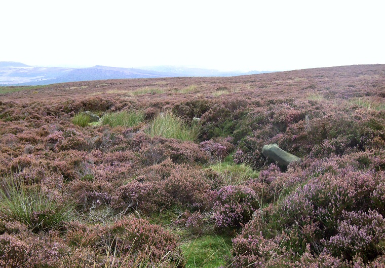
View of the bank looking north east with an arc of three stones visible lining its inner edge.
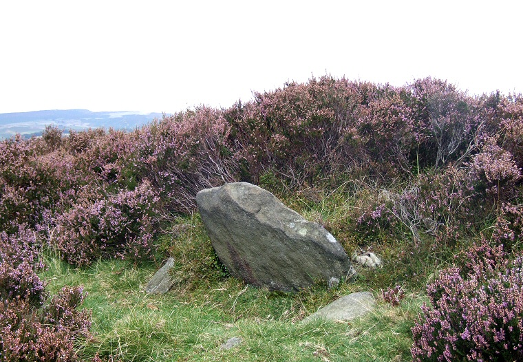
One of the stones of the circle with the bank immediately behind.
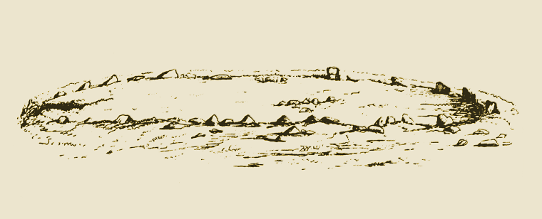
Drawing of Wet Withens by Sir Gardner Wilkinson 1860, looking north. Wilkinson shows a large number of stones present at that time but as his text only records fifteen or sixteen stones, ten of which were standing, it is clear that he has also included many of the packing stones from the bank in his illustration. The 'Chair Stone' is recognisable to the right of the middle of the upper arc with what looks like a couple of fallen stones to its left, these are now missing as are all but one of the stones to the upper left. The remains of a possible cairn are shown to the southeast of the centre of the circle..
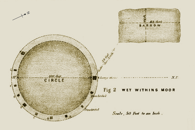
Plan of Wet Withens and the nearby cairn by Rooke Pennington from 1885 (I've added a compass arrow). Pennington shows that most of the stones from the west round to the northeast were missing by this time with eleven stones remaining, although he marks a couple of these as 'doubtful'. If we ignore these doubtful stones and add another to the northwest that he seems to have missed out then we are left with the circle as it is today. The 'Chair Stone' is shown on the right and labelled as 'Large stone'.
Site Visits / Photographs:
September 2007, November 2010.
References:
Andrew, W. 1907. Prehistoric Stone Circles of Derbyshire. In Cox, C. (ed.) Memorials of Old Derbyshire. 70-88.
Armitage, E. 1897. A key to English Antiquities... Sheffield and Rotherham District. Sheffield: Townsend.
Barnatt, J. 1978. Stone Circles of the Peak. London: Turnstone Books.
Barnatt, J. 1987. The Design and Distribution of Stone Circles in Britain... Thesis, (PhD). University of Sheffield.
Barnatt, J. 1986. Bronze Age Remains on the East Moors of the Peak District. D.A.J., Vol 106, 18-100.
Barnatt, J. 2000. ...Later Prehistoric farming communities...in the Peak. D.A.J., Vol 120, 1-86.
Barnatt, J. and Chambers, F. 1996. Recent research at Peak District Stone Circles. D.A.J., Vol 116, 27-48.
Barnatt, J. and Reeder, P. 1982. Prehistoric Rock Art in the Peak District. D.A.J., Vol 102, 33-44.
Barnatt, J. and Robinson, F. 2003. Prehistoric Rock-Art...new discoveries... Peak District. D.A.J., Vol 123, 1-28.
Bateman, T. 1861. Ten years diggings in Celtic and Saxon grave hills in the counties of Derby.... London: Smith.
Burl, A. 1976. The Stone Circles of the British Isles. London: Yale University Press.
Burl, A. 1995. A Guide to the Stone Circles of Britain, Ireland and Brittany. London: Yale University Press.
Edmunds, M. and Seaborne, T. 2001. Prehistory in the Peak. Stroud: Tempus.
Jewitt, L. 1870. Grave-mounds and their Contents.. London: Groombridge.
Jewitt, L. 1884. Half-hours among some English Antiquities. New Edition. London: Allen.
Morgan, V. and Morgan, P. 2001. Rock around the Peak. Wilmslow: Sigma Leisure.
Pennington, R. 1875. Tumuli and Stone Circles near Castleton. Journal ... Royal Anthropological Inst. 377-384.
Thompson, D. 1963. Arbor Low and three other Prehistoric sites in Derbyshire. London: HMSO.
Wilkinson, G. 1860. On some of the vestiges of the Britons near Hathersage. Reliquary, 1, 159-166.
Wood, W. 1848. The History and Antiquities of Eyam. Second Edition. London: Longman.
Historic England Research Records Hob Uid: 311790.
Scheduled Monument: 31233.
National Monuments Record Number: SK 27 NW 1.
HER Number: 5452.
County Number DR 2.
