
Is this the area where the circle once stood?
This
stone
circle is a mystery. At the
time I first visited the site in the late 1990's the area where I thought the stones were located was covered
with a thick carpet of heather.  Rooting around in this heather I uncovered several
large boulders (shown in the photograph inset), were these some of the
twelve stones that my guide book told me remained of an original eighteen?
Rooting around in this heather I uncovered several
large boulders (shown in the photograph inset), were these some of the
twelve stones that my guide book told me remained of an original eighteen?
After some research I realized that these stone were probably not part of the circle and in fact only one stone still remained within an earth embankment, and not in the location I had been looking in.
I returned to Bradup after a space of three or four years. The boulders I had seen before were still there but this time the heather had been burned back, I knew these stone were not the circle, but the area where the stone should have been had been recently ploughed - there was no stone left (photograph above at the top of the page). All I could find was a patch of roughly circular soil that was a slightly lighter colour than the surrounding land, and a pile of boulders at the field edge (photograph below). These all showed deep gouge marks from the bucket of some kind of earth mover. Whether one of these stones is from the circle or not, I don’t know, but it sadly seems that this circle has now been completely destroyed.
Probable Date: Bronze Age
See also Ilkley Moor & Rombalds Moor Introduction
For a more thorough investigation into the fate of Bradup Circle see this page by local expert Paul Bennett.
Rooting around in this heather I uncovered several
large boulders (shown in the photograph inset), were these some of the
twelve stones that my guide book told me remained of an original eighteen?After some research I realized that these stone were probably not part of the circle and in fact only one stone still remained within an earth embankment, and not in the location I had been looking in.
I returned to Bradup after a space of three or four years. The boulders I had seen before were still there but this time the heather had been burned back, I knew these stone were not the circle, but the area where the stone should have been had been recently ploughed - there was no stone left (photograph above at the top of the page). All I could find was a patch of roughly circular soil that was a slightly lighter colour than the surrounding land, and a pile of boulders at the field edge (photograph below). These all showed deep gouge marks from the bucket of some kind of earth mover. Whether one of these stones is from the circle or not, I don’t know, but it sadly seems that this circle has now been completely destroyed.
Probable Date: Bronze Age
See also Ilkley Moor & Rombalds Moor Introduction
For a more thorough investigation into the fate of Bradup Circle see this page by local expert Paul Bennett.

Cleared rocks at the site of Bradup Circle.
An account of the circle by Raistrick appears in the Yorkshire Archaeological Journal of 1929 p356 with an accompanying plan Fig.3. Rather than precis them I've included them both here in entirety:
'Circle at Bradup.
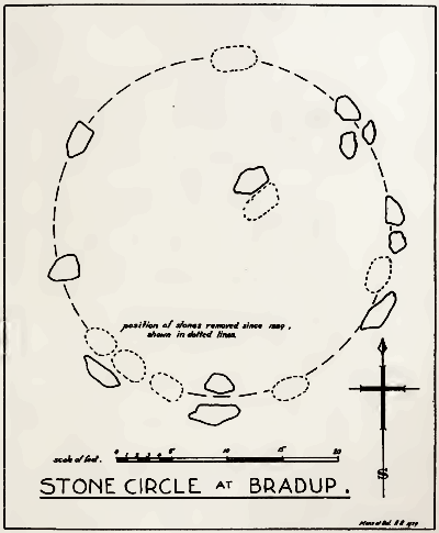 This circle is situated on the west side of the Keighley to Ilkley road, in the
rough pasture called “Brass Castle” (a significant
name), immediately south and west of Bradup Bridge. The circle is approximately 30 feet diameter, but has been very badly damaged at some period since 1885. At that date 18 stones were standing,
but now only 12 remain, though there are large unfilled holes on
the sites from which the other stones have been removed. There
are slight traces of a bank, but the most noticeable feature is the
large size of the stones (Millstone Grit from the neighbouring escarpment)
of which the circle has been made. There are some traces
of a double circle, but it is not possible to be sure of this now. It
seems certain that the stones were removed from this circle to
repair the neighbouring Bradup Bridge, an act of vandalism always
to be deplored. The plan of the circle as it is at present (fig. 3),
will explain its nature. There is no appearance of this circle having been
used for interment, nor any record extant of exploration.'
This circle is situated on the west side of the Keighley to Ilkley road, in the
rough pasture called “Brass Castle” (a significant
name), immediately south and west of Bradup Bridge. The circle is approximately 30 feet diameter, but has been very badly damaged at some period since 1885. At that date 18 stones were standing,
but now only 12 remain, though there are large unfilled holes on
the sites from which the other stones have been removed. There
are slight traces of a bank, but the most noticeable feature is the
large size of the stones (Millstone Grit from the neighbouring escarpment)
of which the circle has been made. There are some traces
of a double circle, but it is not possible to be sure of this now. It
seems certain that the stones were removed from this circle to
repair the neighbouring Bradup Bridge, an act of vandalism always
to be deplored. The plan of the circle as it is at present (fig. 3),
will explain its nature. There is no appearance of this circle having been
used for interment, nor any record extant of exploration.'