
The site known as the Hurlers is the actually the collective name for a group of three stone circles and a pair of nearby standing stones located towards the south-eastern edge of Bodmin Moor in an area rich in prehistoric cairns, settlements and standing stones. The Hurlers close proximity to the road through the village of Minions and easy accessibility has lead to them becoming one of the most well known and popular ancient sites in this part of Cornwall and while the whole area was extensively mined for tin in the past it is remarkable that the site has been left relatively unscathed. The three circles of roughly dressed granite stand close together forming a north-northeast to south-southwest alignment although they are not precisely aligned through their centres (see plan below) and perhaps surprisingly they are not aligned on the rock outcrop of Stowes Hill which dominates the skyline directly to the north (to the left in the photograph above, taken from the edge of the southern circle looking north over the centre circle).
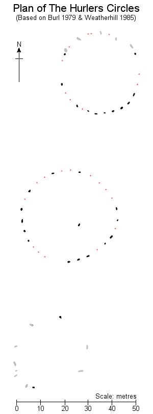 Starting with the northern circle, this was a true circle of about 35 metres diameter and may have originally consisted of twenty-nine or thirty stones. What remains are fifteen stones with eleven still standing, mostly towards the south of the circle (plan left, standing stones drawn black), plus a further four or five fallen stones to the north (drawn grey). The stones vary in height from about a metre to a metre and a half, the slightly taller stones being found towards the south-southeast of the circle. In addition a series of modern marker blocks indicate the position of a further ten missing stones whose holes were located during excavations at the site in the mid 1930s (drawn as red dots). These excavations also suggested the interior of the circle was paved with granite while a further paved pathway 27 metre long and 1.8 metre wide, also of granite, once linked this circle with the centre circle.
The central circle is thought to have originally held twenty-nine stones laid out in a slight egg shape measuring 43 metres by 42 metres. As well as being the largest this is perhaps the best preserved of the three circles with fourteen of its stones still standing and fairly evenly spaced although there are noticeable gaps to the northeast and southwest. The stones are all around a metre and a half in height with those to the south being a shade taller. Missing stones whose positions were located during excavations are again marked with fourteen blocks while a probable final stones location had been lost due to a small tin mining pit. A small stone less than a metre tall that now stands to the south of the centre of the circle was also re-erected after being found buried by the excavators. Interestingly during the course of these excavations the interior of the circle was found to have been laid with quartz crystals, probably the waste product of dressing the stones but which could have been regarded as of ritual significance by the circle builders.
A further 26 metres away are the remains of the southern circle, sadly this is now badly damaged and contains just two opposed standing stones with seven or eight former stones laying nearby, their sizes varying from about a metre to 2.35 metres in length. It is thought this circle originally also consisted of twenty-nine stones set in a true circle of around 33 metres diameter, however this total has to be inferred from the spacing of the surviving stones and comparison with the other two circles as this part of the site was not included in the 1930s excavations.
There are two additional stones that are traditionally associated with the Hurlers, these are the Pipers, located about 100 metres to the west-southwest of the centre circle. These stones stand about 2 metres tall and about the same distance apart, aligned west-southwest to east-northeast. As the photograph below shows they differ from the stones of the circles in being much more regularly shaped and dressed almost square in section and it is debatable whether they are contemporary with the circles or an unrelated more modern addition to the site.
Legend says that the circles were men punished by St. Cleer for playing the Cornish sport of hurling the ball on the Sabbath while the Pipers were a pair of musicians also suffered the same fate. In common with many other prehistoric sites the stones of the circles are also said to be uncountable.
About 500 metres north-northeast of the circles is the round cairn of Rillaton Barrow which contained the Rillaton Cup - a Bronze Age handled cup made of corrugated sheet gold while about 1 kilometre almost due north of the circles stands the low granite dome of rock known as Stowe's Hill. This was chosen as the location of a pair of prehistoric stone walled enclosures, the larger northern enclosure seems to have been a settlement site which contained over a hundred stone built huts while the southern enclosure, known as Stowe's Pound, apparently contained none.
Starting with the northern circle, this was a true circle of about 35 metres diameter and may have originally consisted of twenty-nine or thirty stones. What remains are fifteen stones with eleven still standing, mostly towards the south of the circle (plan left, standing stones drawn black), plus a further four or five fallen stones to the north (drawn grey). The stones vary in height from about a metre to a metre and a half, the slightly taller stones being found towards the south-southeast of the circle. In addition a series of modern marker blocks indicate the position of a further ten missing stones whose holes were located during excavations at the site in the mid 1930s (drawn as red dots). These excavations also suggested the interior of the circle was paved with granite while a further paved pathway 27 metre long and 1.8 metre wide, also of granite, once linked this circle with the centre circle.
The central circle is thought to have originally held twenty-nine stones laid out in a slight egg shape measuring 43 metres by 42 metres. As well as being the largest this is perhaps the best preserved of the three circles with fourteen of its stones still standing and fairly evenly spaced although there are noticeable gaps to the northeast and southwest. The stones are all around a metre and a half in height with those to the south being a shade taller. Missing stones whose positions were located during excavations are again marked with fourteen blocks while a probable final stones location had been lost due to a small tin mining pit. A small stone less than a metre tall that now stands to the south of the centre of the circle was also re-erected after being found buried by the excavators. Interestingly during the course of these excavations the interior of the circle was found to have been laid with quartz crystals, probably the waste product of dressing the stones but which could have been regarded as of ritual significance by the circle builders.
A further 26 metres away are the remains of the southern circle, sadly this is now badly damaged and contains just two opposed standing stones with seven or eight former stones laying nearby, their sizes varying from about a metre to 2.35 metres in length. It is thought this circle originally also consisted of twenty-nine stones set in a true circle of around 33 metres diameter, however this total has to be inferred from the spacing of the surviving stones and comparison with the other two circles as this part of the site was not included in the 1930s excavations.
There are two additional stones that are traditionally associated with the Hurlers, these are the Pipers, located about 100 metres to the west-southwest of the centre circle. These stones stand about 2 metres tall and about the same distance apart, aligned west-southwest to east-northeast. As the photograph below shows they differ from the stones of the circles in being much more regularly shaped and dressed almost square in section and it is debatable whether they are contemporary with the circles or an unrelated more modern addition to the site.
Legend says that the circles were men punished by St. Cleer for playing the Cornish sport of hurling the ball on the Sabbath while the Pipers were a pair of musicians also suffered the same fate. In common with many other prehistoric sites the stones of the circles are also said to be uncountable.
About 500 metres north-northeast of the circles is the round cairn of Rillaton Barrow which contained the Rillaton Cup - a Bronze Age handled cup made of corrugated sheet gold while about 1 kilometre almost due north of the circles stands the low granite dome of rock known as Stowe's Hill. This was chosen as the location of a pair of prehistoric stone walled enclosures, the larger northern enclosure seems to have been a settlement site which contained over a hundred stone built huts while the southern enclosure, known as Stowe's Pound, apparently contained none.

Looking north across the centre circle towards Stowe's Hill

Stones of the centre circle.

The Pipers standing stones frame Stowe's Hill on the skyline.

A sketch of The Hurlers by William Borlase, published in 1754 with north to the left and south to the right. Although Borlase doesn't correctly represent the distances between the circles, he clearly shows the centre circle as having a broader diameter than the other two. In his time he shows sixteen stones in the north circle of which ten are standing or leaning, seventeen in the centre circle with eight or nine standing and just three standing out of twelve stones in the southern circle.
Site Visits / Photographs:
August 1997, August 1999.
References:
Barnatt, J. 1987. The Design and Distribution of Stone Circles in Britain... Thesis, (PhD). University of Sheffield.
Borlase, W. 1754. Observations on the Antiquities, Historical and Monumental of the County of Cornwall. Oxford:
Borlase, W. C. 1872. Naenia Cornubiae - A Descriptive Essay. London: Longmans, Green, Reader and Dyer.
Burl, A. 1976. The Stone Circles of the British Isles. London: Yale University Press.
Burl, A. 1979. Rings of Stone. London: Frances Lincoln Publishers Ltd.
Burl, A. 1995. A Guide to the Stone Circles of Britain, Ireland and Brittany. London: Yale University Press.
Clare, T. 1982. Archaeological Sites of Devon and Cornwall. Ashbourne: Moorland Publishing.
Cope, J. 1998. The Modern Antiquarian. A Pre-Millennial Odyssey through Megalithic Britain. London: Thorsons.
English Heritage. Extract from English Heritage's record of scheduled monuments. NMR: 15232.
Weatherhill, C. 1985. Cornovia. Ancient Sites of Cornwall & Scilly. Penzance: Alison Hodge.