The site often simply referred to as 'Thornborough' consists of a group of three late Neolithic
henge earthworks lying about 500 metres apart on a flat sand and gravel plateau
of land between the River Ure and River Swale.
All three henges would have been roughly the same size with the outer diameter of the banks being about 200 metres with a width of about 20 metres and standing some 4 metres in height. It is now thought that they would have been covered with locally sourced gypsum crystals making them glitter in the sun and perhaps echoing the chalk earthworks of the south of England.
Within the banks a 12 metre leveled berm separated them from the internal ditches which were each about 20 metres wide and 3 metres deep over which a causeway lead into the central enclosed area which measured between 80-90 metres in diameter. A further segmented outer ditch beyond the banks gave the henges a total diameter of between 240 and 275 metres.
Each henge had a pair of entrances measuring about 15 metre wide situated towards the northwest and the southeast, however these entrances do not align between each henge. Also although they follow a roughly northwest to southeast line the henges do not form a straight alignment, the central henge causing the line to be be slightly dog-legged to the east (see first satellite image below).
The northern henge is probably the best preserved but as it is covered in a small plantation appreciating the overall size and shape of the monument is rather difficult. The bank still measures up to 3 metres high in places with the ditch surviving to 2.5 metres depth. Both entrances are still clearly defined.
The central henge (shown in the panoramic photograph above) is the most accessible and although the bank reaches nearly 4.5 metres high in places in other parts of its circuit it has been badly damaged and stands less than a metre in height. There was little trace of the interior ditch when I visited the site in snowy condition although it is said to be up to a metre deep in places, it does however show up exceptionally well as a cropmark in some years when seen in aerial photographs (shown in one of the satellite images below).
The southernmost of the three monuments is badly damaged, particularly on its eastern side but it is still recognisable as a henge structure and the banks are still wide although they only stand between 30cm and 2 metres high. It was lucky not to be further damaged by a railway branch-line that used to pass a few metres to the south.
Although the henges are the most visible prehistoric monuments in this landscape they were not the first, or indeed the last (see black and white plan below). The area was already the focus of ceremonial activity long before they were built with a middle Neolithic barrow and two possible mortuary enclosures of the same period located within a few hundred metres of the henges. Fascinatingly the central henge was found to have been constructed over a pre-existing 1200 metre long cursus - an earthwork formed from parallel banks and ditches that may have had some processional function. What is striking is that the alignment of the henges is perpendicular to the cursus, was this a later group of people or religious belief stamping its authority by re-orienting the ceremonial landscape?
The area around the henges continued to be utilised into the Bronze Age with around ten round barrows built within the local landscape and an avenue of timber posts of unknown purpose leading into the area between the central and southern henges.

The well preserved bank of the north henge.

Northwest entrance bank of the south henge.
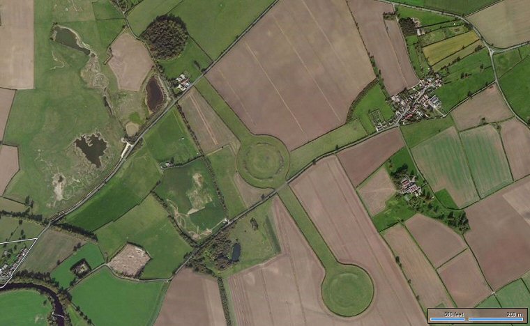
Bing Satellite image showing the relationship between the three henges at Thornborough.
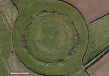
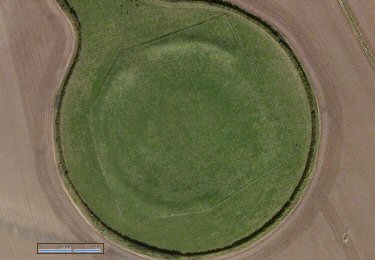
Closer Bing views of the central henge (left) and southern henge (right). At the central henge the entrances to the northwest and southeast are still visible and the banks are mostly still clearly defined whereas the southern henge is a much more erroded site, with low banks and only the entrance at the northwest still visible.
Both images to same scale - scale bars represent 100ft and 25m.

I've included this recent Bing satellite image of the central henge as while the banks are not particularly well defined the internal ditch appears as a striking clear crop-mark.

Satellite image overlaid with the course of cursus (its eastern terminal has not been located) as well as some of the other monuments of the Thornborough landscape. Circles represent either existing or cropmark barrows.