|
If
the timelapse above does not play please try this direct
link.
|
|
|
Timelapse
looking northeast towards the full moon rising behind the notch in the
Fairy Stone at Hordron Edge stone circle in Derbyshire. The composition
is nearly perfect but I wish I'd planned ahead and taken a source of
light to illuminate the stone for the duration of the moonrise - it
would also have allowed me to reduce the exposure to bring out the detail
on the surface of the moon. Incidentally, it was so cold that evening
that while waiting for the images to record, a bottle of water in my
rucksack developed a thick layer of ice.
The video is 19 seconds long and consists of 566 images shot at 5 second intervals between 5:01pm and 5:48pm on 29th January 2010. Main Hordron Edge stone circle page. (Video hosted on Vimeo © www.stone-circles.org.uk) |
|
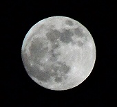 The
full moon as it appeared from Hordron Edge that evening, The
full moon as it appeared from Hordron Edge that evening, |