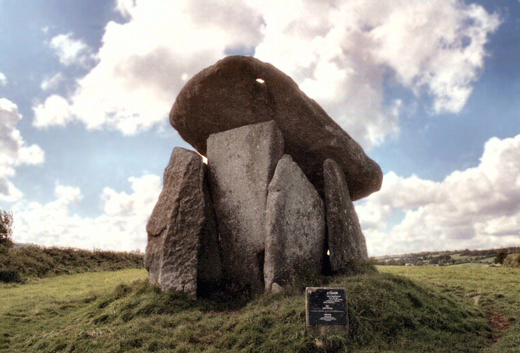
 View of the entrance and antechamber of Trethevy Quoit looking west.
 Trethevy Quiot is a very attractive Penwith Chambered Tomb, a type of portal
dolmen, that stands on the south-eastern edge of Bodmin Moor on a low rise of land
bounded on three sides by a pair of streams that eventually flow into the
River Seaton and out to the sea near 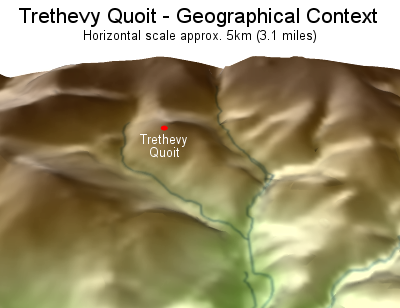 Downderry. A slight dip in the land to the north creates a small
'island' - Trethevy Quoit stands very close to its highest point (3D elevation with streams shown left, the high ground at the top is the southern edge of Craddock Moor. View looking north). The monument was first recorded by the antiquarian John Norden as far back as the late 16th century when he quaintly described the towering blocks of granite as 'a little howse raysed of mightie stones'. He was correct in describing it as a house, a house not for the living, but for the dead.
The base of the monument consists of a low roughly circular 6 metre diameter mound of stones and cobbles which are the remains of a surrounding cairn which would have been piled against the sides of the chamber. How high the cairn stood or how far it extended is not known but it is unlikely to have covered the chamber completely, the upper parts and the capstone were probably left exposed and an area left clear in front of the tomb to act as a passageway and a forecourt perhaps for the periodic enactment of rituals and funerary rites.
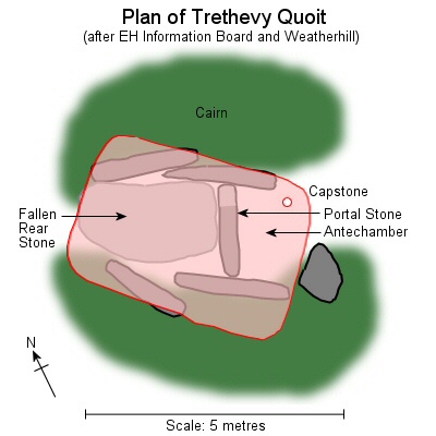 Set within the mound on the original ground surface are the
slabs of the burial chamber itself. A pair of overlapping stones on each side form a roughly northwest to southeast aligned box structure measuring about 2 metres by 1.8 metres internally with a stone at the
rear of the chamber which has now partly collapsed into the chamber and a blocking or portal stone towards
the southeast end. Two of the side slabs extend beyond the portal stone to create an antechamber with a further pillar of a much squarer section standing just beyond. This may have been one of a pair that formed the outer limit of the antechamber.
The chamber is topped with a precariously balanced capstone, a beautifully thin sliver of smooth granite that measures 3.5 metre long by 2.7 metres broad but averages only about 30 cm thick and is said to weigh about 20 tons. The capstone now rests on the portal stone and the rear two side slabs following the collapse of the rear chamber stone but given the length of this back stone it is probable that the capstone was originally supported by the rear stone, the portal stone and possibly the two pillars beyond the antechamber. When the rear stone collapsed is not known but it had already fallen by Norden's time, it is even possible it occurred during the building of the tomb.
Trethevy is one of the most well known and most popular of the Neolithic chambered tombs in Cornwall, not just because of its good preservation but also because it contains a couple of unusual and not fully understood features. The first is the portal stone, the tallest stone of the monument which extends some nearly 3 metres above the cairn and is a beautifully smooth faced flat topped and square edged slab that has a notch at its lower eastern corner about 60 cm long. These is some debate about whether this notch was cut by the builders of the tomb or whether it is the result of a natural fracture in the rock, with the stone being specially chosen because of this feature, the notch being assumed to form an access point to the interior of the chamber for the deposition or removal of human remains. The other unusual feature is a 15-20 cm oblong hole cut through the eastern corner of the capstone, this does seem to be man-made but what purpose it served is not known. Norden considered that it was meant to hold a staff or pole while others have suggested that it may have been cut as a spy-hole through which to observe a particular celestial event but as the capstone has shifted from its original position, what this event might have been may never be known.
Notes:
Trethevy has had several different spellings over the years including Trethevie, Tretheuie, Trevedi, Tredavy, or Trevethi which are said to translate as 'the place of the grave'. An alternate Cornish name is Chi-an-Kowr - 'The Giant's House'.
Most photographs of Trethevy Quoit are from roughly the same angles as shown on this page, rarely from the rear of the chamber and with good reason, picture postcard views are not possible due to the proximity of a house just a few metres to the east of the tomb (no offence to the occupants!).
The esteemed 20th century archaeologist and author Leslie Grinsell believed the notch in the portal stone to be natural as did local antiquarian William Copeland Borlase writing in the 19th century. However Borlase quotes a geologist, a Mr S. R. Pattison, as considering it 'exhibits marks of art', ie it was man-made. Borlase adds that Pattison had this to say about the granite used to construct the chamber saying it 'occurs in boulders about half-a-mile distant. There is a broad upland valley intervening between Trethevy and the granite. The builders must therefore have credit for the exertion of combined strength and skill, in transporting these enormous masses of rock across the hollow, and up the hill on which they now stand'. However he doesn't specify whereabouts these boulders were, if anybody knows, please let me know.
Trethevy is located 1.6 miles (2.6 kilometres) almost due south of The Hurlers stone circle.
 Downderry. A slight dip in the land to the north creates a small
'island' - Trethevy Quoit stands very close to its highest point (3D elevation with streams shown left, the high ground at the top is the southern edge of Craddock Moor. View looking north). The monument was first recorded by the antiquarian John Norden as far back as the late 16th century when he quaintly described the towering blocks of granite as 'a little howse raysed of mightie stones'. He was correct in describing it as a house, a house not for the living, but for the dead.
 The base of the monument consists of a low roughly circular 6 metre diameter mound of stones and cobbles which are the remains of a surrounding cairn which would have been piled against the sides of the chamber. How high the cairn stood or how far it extended is not known but it is unlikely to have covered the chamber completely, the upper parts and the capstone were probably left exposed and an area left clear in front of the tomb to act as a passageway and a forecourt perhaps for the periodic enactment of rituals and funerary rites.
 Set within the mound on the original ground surface are the
slabs of the burial chamber itself. A pair of overlapping stones on each side form a roughly northwest to southeast aligned box structure measuring about 2 metres by 1.8 metres internally with a stone at the
rear of the chamber which has now partly collapsed into the chamber and a blocking or portal stone towards
the southeast end. Two of the side slabs extend beyond the portal stone to create an antechamber with a further pillar of a much squarer section standing just beyond. This may have been one of a pair that formed the outer limit of the antechamber.
 The chamber is topped with a precariously balanced capstone, a beautifully thin sliver of smooth granite that measures 3.5 metre long by 2.7 metres broad but averages only about 30 cm thick and is said to weigh about 20 tons. The capstone now rests on the portal stone and the rear two side slabs following the collapse of the rear chamber stone but given the length of this back stone it is probable that the capstone was originally supported by the rear stone, the portal stone and possibly the two pillars beyond the antechamber. When the rear stone collapsed is not known but it had already fallen by Norden's time, it is even possible it occurred during the building of the tomb.
Trethevy is one of the most well known and most popular of the Neolithic chambered tombs in Cornwall, not just because of its good preservation but also because it contains a couple of unusual and not fully understood features. The first is the portal stone, the tallest stone of the monument which extends some nearly 3 metres above the cairn and is a beautifully smooth faced flat topped and square edged slab that has a notch at its lower eastern corner about 60 cm long. These is some debate about whether this notch was cut by the builders of the tomb or whether it is the result of a natural fracture in the rock, with the stone being specially chosen because of this feature, the notch being assumed to form an access point to the interior of the chamber for the deposition or removal of human remains. The other unusual feature is a 15-20 cm oblong hole cut through the eastern corner of the capstone, this does seem to be man-made but what purpose it served is not known. Norden considered that it was meant to hold a staff or pole while others have suggested that it may have been cut as a spy-hole through which to observe a particular celestial event but as the capstone has shifted from its original position, what this event might have been may never be known.
Notes:
Trethevy has had several different spellings over the years including Trethevie, Tretheuie, Trevedi, Tredavy, or Trevethi which are said to translate as 'the place of the grave'. An alternate Cornish name is Chi-an-Kowr - 'The Giant's House'.
Most photographs of Trethevy Quoit are from roughly the same angles as shown on this page, rarely from the rear of the chamber and with good reason, picture postcard views are not possible due to the proximity of a house just a few metres to the east of the tomb (no offence to the occupants!).
The esteemed 20th century archaeologist and author Leslie Grinsell believed the notch in the portal stone to be natural as did local antiquarian William Copeland Borlase writing in the 19th century. However Borlase quotes a geologist, a Mr S. R. Pattison, as considering it 'exhibits marks of art', ie it was man-made. Borlase adds that Pattison had this to say about the granite used to construct the chamber saying it 'occurs in boulders about half-a-mile distant. There is a broad upland valley intervening between Trethevy and the granite. The builders must therefore have credit for the exertion of combined strength and skill, in transporting these enormous masses of rock across the hollow, and up the hill on which they now stand'. However he doesn't specify whereabouts these boulders were, if anybody knows, please let me know.
Trethevy is located 1.6 miles (2.6 kilometres) almost due south of The Hurlers stone circle.
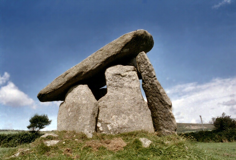
View of Trethevy Quoit looking northeast.
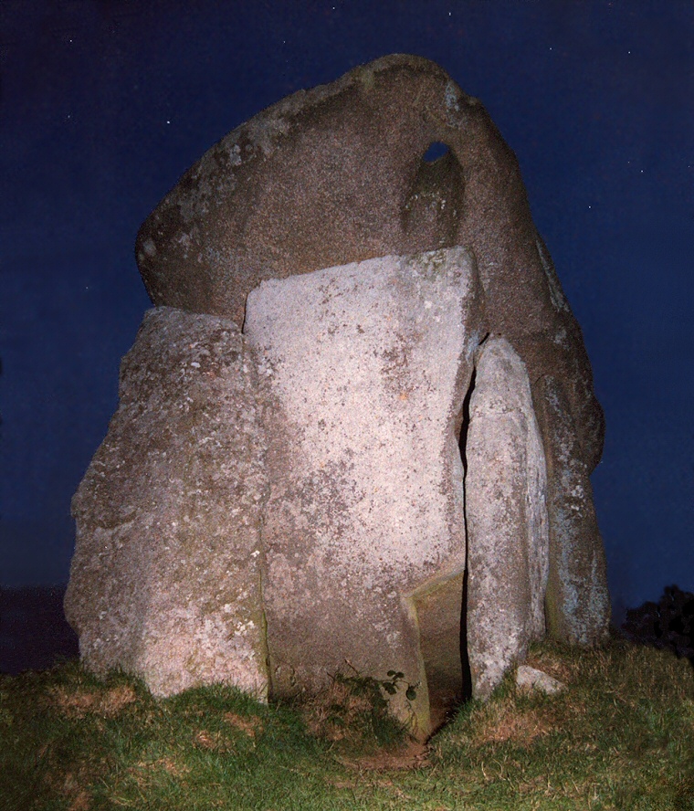
Trethevy Quoit by night, looking northwest at the entrance to the chamber, the large stone to the left does not actually support the capstone. From this angle the hole through the capstone and the notch in the bottom right of the blocking or portal stone are clearly visible - the stone seen through the notch is the fallen back stone.
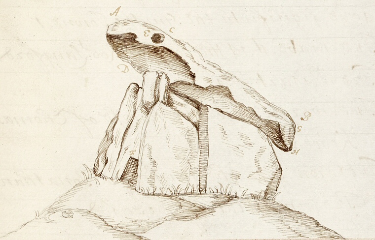
A beautiful pen and ink sketch of Trethevy Quoit by John Norden from a manuscript completed around 1610. Norden uses a strange perspective to represent the hole through the capstone but otherwise it is a pretty good study of the monument and appears to show that the capstone was already resting on the rear side slabs by that time.
Image courtesy of Trinity College, Cambridge.
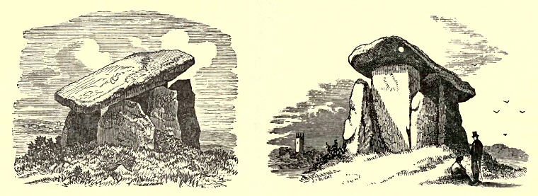
Two antiquarian views of Trethevy Quoit published in Borlase 1872. Borlase credits the image on the left as 'from a photograph by Mr. Lobb of Wadebridge' and the other, which appears in Blight 1858, as from 'the accomplished pencil of J. T. Blight, Esq., F.S.A.'. Borlase states that the higher end of the capstone stands to a height of some 4 metres, the lower end to 2.3 metres.
Site Visits / Photographs:
August 1997, August 1999.
References:
Blight, J. 1858. Ancient Crosses and other Antiquities in the East of Cornwall. London: Simpkin
Borlase, W. C. 1872. Naenia Cornubiae - A Descriptive Essay. London: Longmans, Green, Reader and Dyer.
Burnham, A. (Ed.). 2018. The Old Stones. Field Guide...Megalithic Sites of Britain and Ireland. London: Watkins.
Clare, T. 1982. Archaeological Sites of Devon and Cornwall. Ashbourne: Moorland Publishing.
Cope, J. 1998. The Modern Antiquarian. A Pre-Millennial Odyssey through Megalithic Britain. London: Thorsons.
Dyer, J. (Editor). 1993. Discovering Prehistoric England. Princes Risborough: Shire Publications Ltd.
Grinsell, L. V. 1936. The Ancient Burial Mounds of England. London: Methuen.
Hawkes, J. 1986. The Shell Guide to British Archaeology. London: Michael Joseph Ltd.
Lynch, F. 1997. Megalithic Tombs and Long Barrows in Britain. Princes Risborough: Shire Publications Ltd.
Norden, J. c1610. Speculum Brittaniae. Manuscript - Trinity College, Cambridge.
Weatherhill, C. 1985. Cornovia. Ancient Sites of Cornwall & Scilly. Penzance: Alison Hodge.
Historic England Research Records Hob Uid: 434959. NMR Number: SX 26 NE 1.
National Monument Number: 15003. County Number: Cornwall 24.