
Although Waylands Smithy had been excavated between 1919-1920 the full history of the site was not uncovered until further excavations were carried out by Richard Atkinson and Stuart Piggott between 1962-3 and the partially restored megalithic barrow we see today represents the final form of a multi-stage Neolithic monument that began its life as a place of the dead.
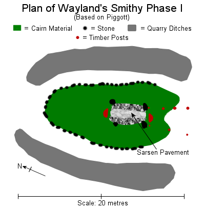 Atkinson and Piggott's discovery buried beneath the mound of the existing barrow consisted of a sarsen boulder pavement measuring nearly 5 metres by 1.5 metres lined along its eastern and western flanks by stone banks with large D shaped spilt oak posts sunk into pits at the northern and southern ends (inset plan left). These posts are thought to have held a ridge pole upon which sarsen slabs and wooden planks were laid to form a box-like mortuary structure standing 1.4 metres tall, with the planks being removable to allow the periodic insertion of new burials. Two lines of posts converging on the southern end of this structure may have formed a focus for ritual activity.
 Within the chamber itself the bodies of nine men and three or four women mainly aged between about 20-40 and a child of about 9-10 years old had been placed while three flint arrowheads found in association with the remains may represent an unpleasant end for three of those individuals. Radiocarbon dates suggest that these interments took place sometime around 3610-3550 BC. Later, after a period of abandonment, a cairn of sarsen boulders along with chalk rubble quarried from side ditches was heaped up over the mortuary structure to a height of nearly 2 metres to form an oval barrow measuring about 16 metres long by 8 metres at its widest point with sarsen blocks placed against the sides of the mound to form a low revetment wall. Radiocarbon dates suggest this occurred between 3520-3470 BC. This barrow however only had a short life as the radiocarbon dates further suggest the building of the larger Phase II megalithic barrow we see today occurred shortly afterwards, sometime between 3460–3400 BC.
 The ditches of the earlier barrow had either silted up or were filled in and its mound was subsumed within a much larger body of a long trapezoid chalk rubble and turf barrow. This measures about 56 metres long in its reconstructed form (inset plan left) although the side ditches from which the chalk was quarried are now no longer visible, perhaps being filled in later in prehistory or the during the Roman period when the area around the barrow was given up to cultivation.
 The wider southern end of the barrow was faced with six massive sarsen slabs up to 3 metres tall, sadly only four of these facade stones remain, in the photographs above and below the missing stones would have stood to the left of the left hand pair and in the centre of the right hand pair. In the reconstruction drystone walling is used to link the facade stones, this was also employed between some of the smaller sarsen kerb slabs used to line the barrow mound.
Through a gap between the facade stones a 6 metre passage lined with sarsen slabs lead first through an antechamber into a cruciform or 'transcepted' arrangement of chambers consisting of a terminal chamber and two lateral chambers capped with further sarsen slabs weighing up to 3.5 tons. Within this part of the barrow the disarticulated remains of eight bodies including a child were recovered by Peers and Smith in their early 20th century excavations, however it is entirely probable that other remains had already been removed from these chambers either in later prehistory or in historic times so the total number of people laid to rest within Wayland's Smithy will probably never be known. A single complete inhumation found between the barrow mound and the western side ditch is undated but is probably a later intrusive burial, perhaps dating from the Bronze Age. After an unknown period of use Wayland's Smithy fell quiet and was left abandoned until filling in of the chambers with chalk rubble began, finds of Beaker sherds within the infill suggest that this process could have taken place sometime in the middle to late 3rd millennium BC as cultural beliefs shifted towards the end of the Neolithic and beginning of the Bronze Age and the tombs of the ancestors were largely consigned to a bygone age.
There are many legends attached to Wayland's Smithy that centre around the Anglo-Saxon Weland, or in the Norse - Volund or Völundr, that date back at least a thousand years. This account was recorded in 1738 by the antiquary Francis Wise -
'At this place lived formerly an Invisible Smith, and if a traveller's Horse had lost a Shoe upon the road, he had no more to do than to bring the Horse to this place with a piece of money, and leaving both there for some little time, he might come again and find the money gone, but the Horse new shod'.
Another story claims Wayland was the blacksmith who provided the shoes for the famous Uffington White Horse which is located less than a mile and a half away to the northeast and which itself gallops towards the nearby late Bronze Age / early Iron Age earthworks of Uffington Castle hillfort. Other legends say a golden coffin is buried nearby and that an underground passage leads from Wayland's Smithy to the nearby village of Ashbury.
Additional notes:
Two strips of iron found buried by one of the facade stones were originally thought to be Iron Age 'currency bars', these are now thought to be broken pieces of a crowbar lost in an attempt to dislodge one of the facade stones in the 18th century.
However Sir Richard Colt Hoare recorded that there were only four facade stones (all fallen) by the early 19th century (Ancient Wilts., ii, 47. 1821 in Crawford 1925).
As is usually the case with tombs of this period, no grave goods were found although a quernstone found to the left of the passage may represent some kind of ritual deposit.
Darvill (2004) suggests that the filling of the chambers and closing of the barrow was to 'protect' the burial remains. Not necessarily. Perhaps the purpose was to protect the living rather than the dead. As belief systems changed in the late Neolithic / early Bronze Age the barrow relics of previous generations may have been regarded with suspicion and superstition, to be best avoided and blocked up to prevent the spirits of the dead wandering abroad. This was taken to extremes with the massive blocking stones placed across the entrance to West Kennet long barrow in Wiltshire.
Darvill (2004) alludes to the contrast between the shapes of the facade stones, either squat lozenge or tall and flat topped and suggests this may represent some form of female / male symbolism which immediately put me in mind of a similar duality that exists in the stones of the West Kennet Avenue leading into Avebury. On the Wayland's Smithy page of themodernantiquarian.com website, forum member wysefool comes to the same conclusion ('Female and Male stones?' Posted by wysefool 4th November 2003).
Many thanks to Mark Steinhardt for providing an authoritative date for the Berkshire charter mentioned in the text above. Mark's website

Front and side view showing some of the kerb stones running along the sides of the barrow.

View along the entrance passageway towards the chamber. I can't find any mention of the low stone in the foreground of this photograph so don't know if this was a 'sill stone' as sometimes found in portal dolmens or whether it was a later blocking stone placed there during the final closing of the tomb.

The antiquarian view. John Aubrey's sketch of Wayland's Smithy from the late 17th century reproduced in O. G. S. Crawford's 'The Long Barrows of the Cotswolds' 1925. While Aubrey draws a rather confusing jumble of stones representing the chambers, possibly reflecting the poor state of preservation of the site, the sketch is nevertheless reasonably accurate for the time and shows a good representation of the size and shape of the mound.

A rather nice illustration of Wayland's Smithy by John Yonge Akerman showing the ruinous state of the site in 1847. Drawn to the same orientation as the other plans on this page, with the entrance on the right hand side.

Akerman's plan of the site from 1847 with the entrance to the right. Akerman shows that the uprights of the chamber and passage were largely still intact and as we see them today but that only a single capstone remain in place, over the eastern chamber. The other capstones were replaced during the reconstruction.
Site Visits / Photographs:
August 1997.
References:
Akerman, J. 1847. Observations on... Wayland Smith's Cave. Archaeologia, Vol 32, 312-314.
Bayliss, A. Whittle, A. Wysocki, M. 2007. Abstract: the Date of the Wayland's Smithy Long Barrow.
Brown, I. 2009. Beacons in the Landscape - The Hillforts of England and Wales. Oxford: Oxbow Books.
Crawford, O. G. S. 1925. The Long Barrows of the Cotswolds. Gloucester: John Bellows.
Darvill, T. 2004. Long Barrows of the Cotswolds and surrounding areas. Stroud: Tempus Publishing Ltd.
Darvill, T. 2010. Prehistoric Britain. 2nd Edition. Abingdon: Routledge.
Dyer, J. (Editor). 1993. Discovering Prehistoric England. Princes Risborough: Shire Publications Ltd.
Godwin, F. and Anderson, J.R.L. 1987. The Oldest Road: The Ridgeway. London: Whittet Books.
Grinsell, L. V. 1936. The Ancient Burial Mounds of England. London: Methuen.
Hawkes, J. 1986. The Shell Guide to British Archaeology. London: Michael Joseph Ltd.
Peers, C. R. and Smith, R. A. 1921. Wayland's Smithy, Berkshire. Antiquaries Journal, 1, 183-198.
Pettigrew, T. 1860. On the History and Antiquities of Berkshire. Journal Brit. Arch. Assoc., 16, 25-49.
Piggott, S. nd. Unchambered Long Barrows in Neolithic Britain.
Thomas, J. 1999. Understanding the Neolithic. London: Routledge.
Westwood, J. 1986. Albion. A Guide to Legendary Britain. London: Book Club Associates.
Wright, T. 1860. On the Legendary History of Wayland Smith. Journal Brit. Arch. Assoc., 16, 50-58.
Historic England Research Records Hob Uid: 225393. NMR Number: 21775. Scheduled Monument Number: 1008409.