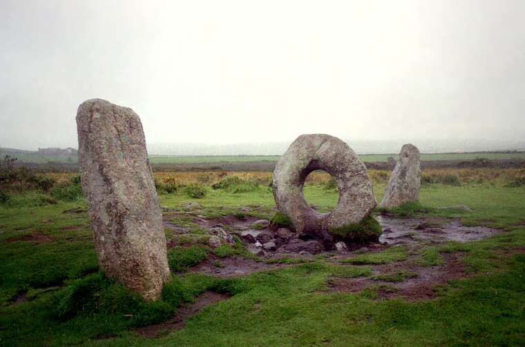
 A murky day at the Men-an-Tol in late August 1997, looking roughly southwest. |
| The Men-an-Tol
which translates from the Cornish Mên-an-Tol as 'stone of the hole' is a stone setting located some distance
to the east of a minor road that runs from the villages of Trevowhan to Madron on the northern edge of Land's End. Its instantly recognisable form makes it probably the most well known prehistoric monument in Cornwall as well as one of the most visited, what it represents though has long been a mystery. Besides the iconic granite setting of the two uprights framing the holed stone there are several others stones on site, either standing or fallen and the recent discovery of further buried stones beneath the turf has shed new light on what kind of monument the Men-an-Tol may once have been. The first drawings of the site come from the Cornish antiquarian and vicar of Ludgvan, William Borlase, who in the mid 18th century illustrated a triangular arrangement of four stones (image below). Two of these were the present uprights with a further fallen slab just to the west and the holed stone set slightly further to the southeast than it is today and with a slightly different orientation. If Borlase's plan is accurate then the stone stood with its long axis along a northwest to southeast line, the view through the hole being to the northeast and southwest. Borlase was at a loss to explain the meaning of the stones, being of the opinion that they 'could be of no use, but to superstition. But to what particular superstious Rite appropriated is uncertain'. It seems that the holed stone was moved slightly in the following years as the two illustrations at the bottom of the page, both from the 19th century, show it to be almost in line with the two uprights. In 1827 William Cotton shows the same four stones as Borlase but forty years later John Thomas Blight sketches a couple more stones to the west, one fallen and one upright. (in the foreground of Blight's illustration below). Writing in 1864 Blight was also clear on what he thought the stones represented, he stated 'From the positions of these stones it seems probable that they are the remains of a circle'. From his illustration it can be imagined that they may have indeed formed an arc of a destroyed stone circle. Opinions on what kind of monument the Men-an-Tol represents have varied over the years. In the early 20th century the famed astronomer Sir Norman Lockyer considered the arrangement to have been used for the observance of sunrises and sunsets at various times of the year (Lockyer's proposed alignments shown at the bottom of the page). More recently authors Chris Tilley and Wayne Bennett have proposed that the alignment of the three main stones points to the midsummer sunrise to the northeast and midwinter sunset to the southwest. However given the close proximity of the two uprights and the fact that both lean (an assuming that they are in their original positions) any potential alignments might cover a fairly wide arc of sky at those times of the year, the theory also take no account of the other stones on site. The authors also point to the close proximity of the stone circle of Boskednan less than 800 metres to the east-northeast as possibly being significant (also shown on Lockyer's plan). Another theory that was popular in the 20th century was that the two uprights and the holed stone may have been the remains of a chambered tomb with the circular stone acting as an entrance or portal stone, perhaps as a symbolic link between this life and a possible afterlife. However given the distance between the stones and the small pillar-like forms of the uprights as opposed to the more slab-like forms used in other Cornish tombs this would seem unlikely. It is however conceivable that the holed stone originally came from such a monument and was incorporated into the stone setting after the tomb went out of use or was dismantled as beliefs changed through the long course of prehistory. A small mound of cobbles less than half a metre high exists just to the southeast of the stones, this has been interpreted as the possible remains of a burial cairn and it is even possible that the holed stone may have come from a cist within the cairn, but at the moment this theory remains unproven. 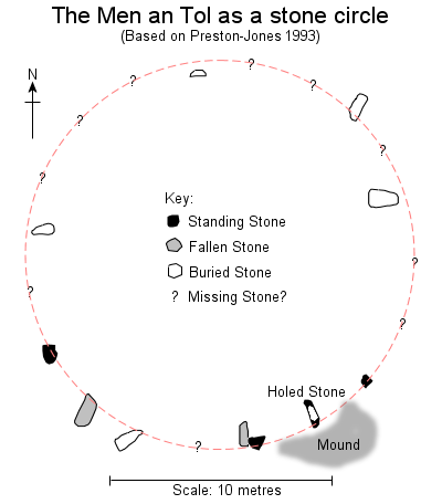 Visitor pressure over the years had lead to increased erosion of the site, particularly around the holed stone. It was set in concrete in the mid 20th century but due to continued damage to the ground around the stones it was decided in 1992 to carry out further consolidation of the site by filling in holes with rocks and then re-turfing over them. During this process the site was cleared of the encroaching gorse and the ground was probed with metal poles to see if any other stones remained hidden beneath the earth - they did. The discovery of further buried stones changed the way the site was interpreted and it now seems increasingly likely that the stones once formed part of a stone circle - just as Blight had predicted (inset plan left). Visitor pressure over the years had lead to increased erosion of the site, particularly around the holed stone. It was set in concrete in the mid 20th century but due to continued damage to the ground around the stones it was decided in 1992 to carry out further consolidation of the site by filling in holes with rocks and then re-turfing over them. During this process the site was cleared of the encroaching gorse and the ground was probed with metal poles to see if any other stones remained hidden beneath the earth - they did. The discovery of further buried stones changed the way the site was interpreted and it now seems increasingly likely that the stones once formed part of a stone circle - just as Blight had predicted (inset plan left). Currently the site is known to consist of eleven stones - the holed stone, three other uprights of about 1.2 metres in height and seven further fallen stones, some of which are partially visible poking through the turf while other remain completely buried. When taken together the positions of the known stones would describe a circle about 18 metres in diameter with the holed stone standing to the southeast of the ring, if Borlase was accurate in his plan then it would have been closer to the circumference in his time than it is today. Estimating the distance between the stones Ann Preston-Jones suggests that the circle would originally have held twenty stones (location of suggested missing stones marked as question marks on the plan) and that the dimensions of the circle combined with the size and number of stones would fit well within the existing stone circle tradition of Cornwall. 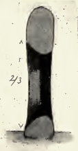 The role that the holed stone played in the circle remains, however, a mystery (to be totally correct the holed stone is the Men-an-Tol although the name is now applied to the whole site). It measures about 1.2 metres in diameter and while its western face is rather flat with the hole through it measuring about 48 cm on this side, the eastern face is much more beveled and here the diameter of the hole is more like 55 cm (section through the stone shown inset, with east face to to the left. Credited to Lukis, in Locker 1906). Although some authors in the past believed the hole was deliberately carved it is now thought to be a natural feature formed as a solution basin when the stone lay horizontally at the top of a rock stack with its eastern face upwards, the hole being gradually eroded by water over a time span that could possibly be counted in millions of years. It is probable that the stone was deliberately chosen in prehistory due to its unusual nature and then incorporated within the stone circle, although it may have previously formed part of another monument. Tilley and Bennett suggest that a suitable source for the stone may have been the southern end of Zennor Hill some 3 miles (4.75 km) to the northeast where a similar stone still exists in situ along with several rock stacks just a few hundred metres from the chambered tomb of Zennor Quoit, which may point to a link between natural rock features including holed stones and Neolithic tombs. The role that the holed stone played in the circle remains, however, a mystery (to be totally correct the holed stone is the Men-an-Tol although the name is now applied to the whole site). It measures about 1.2 metres in diameter and while its western face is rather flat with the hole through it measuring about 48 cm on this side, the eastern face is much more beveled and here the diameter of the hole is more like 55 cm (section through the stone shown inset, with east face to to the left. Credited to Lukis, in Locker 1906). Although some authors in the past believed the hole was deliberately carved it is now thought to be a natural feature formed as a solution basin when the stone lay horizontally at the top of a rock stack with its eastern face upwards, the hole being gradually eroded by water over a time span that could possibly be counted in millions of years. It is probable that the stone was deliberately chosen in prehistory due to its unusual nature and then incorporated within the stone circle, although it may have previously formed part of another monument. Tilley and Bennett suggest that a suitable source for the stone may have been the southern end of Zennor Hill some 3 miles (4.75 km) to the northeast where a similar stone still exists in situ along with several rock stacks just a few hundred metres from the chambered tomb of Zennor Quoit, which may point to a link between natural rock features including holed stones and Neolithic tombs.
The holed stone was known in the past as the 'Devil's Eye' and the 'Crick Stone' and was the source of many local legends citing its healing properties for those who would pass through it, especially for the easing of back pains or for children who are said to have been cured of rickets. Date: While the stone circle may be Bronze Age, the holed stone may have come from a previous Neolithic monument. The Men-an-Tol stands a short distance from the chambered tombs of Lanyon Quoit and Chun Quoit. |
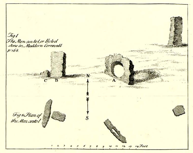 Illustration and plan of the Men-an-Tol as it was in the 18th century by William Borlase. Assuming Borlase's drawing is accurate then the holed stone stood slightly out of alignment with the other two uprights, he was clear in his text that the stones formed a triangular setting in his time. |
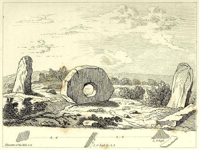 A fine sketch of the Men-an-Tol by William Cotton 1827, not withstanding the rather small hole in the centre stone. Cotton draws the holed stone in a slightly different position to Borlase, it is now more in line with the uprights. |
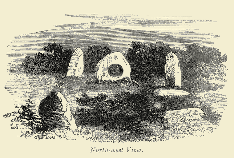 J. T. Blight's illustration of the Men-an-Tol published in 1864. Blight shows the remaining stones as forming an arc and in his text he states 'From the positions of these stones it seems probable that they are the remains of a circle'. He may well have been right. |
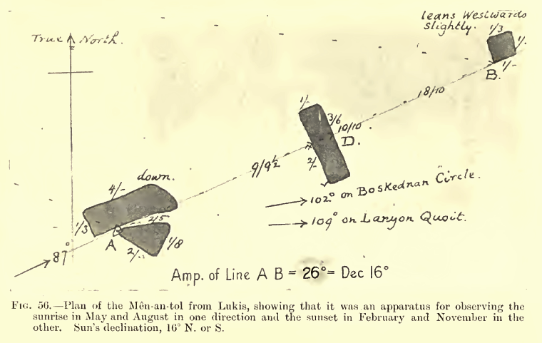 Sir Norman Lockyer's proposed alignments at the Men-an-Tol from 1906. Lockyer believed that February, May, August and November were important times in his suggested May-November-May prehistoric agricultural year. Tilley and Bennett propose June sunrises and December sunsets as the alignment of the site. It seems to me that the stones are so close together that the range of lines drawn between them (assuming they are in their original positions) would describe an arc of sky wide enough to make their use for more than the vaguest observations rather suspect. Locker seems to have confused the tomb of Lanyon Quoit with Mulfa Quoit, Lanyon is actually south of the Men-an-Tol. |
Site Visits / Photographs: August 1997, August 1999. References: Blight, J. 1861. A week at The Lands End. London: Longman, Green, Roberts. Blight, J. 1864. The Holed Stones of Cornwall. Archaeologia Cambrensis, Volume 10, Issue 40, 292-299. Blight, J. 1885. Churches of West Cornwall ... Antiquities of the District. Second Edition. Oxford: Parker. Borlase, W. 1754. Observations ...Antiquities, Historical and Monumental of the County of Cornwall. Oxford: Clare, T. 1982. Archaeological Sites of Devon and Cornwall. Ashbourne: Moorland Publishing. Cope, J. 1998. The Modern Antiquarian. A Pre-Millennial Odyssey through Megalithic Britain. London: Thorsons. Cotton, W. 1827. Illustrations of Stone Circles, Cromlechs ... in the West of Cornwall. London: James Moyes. Dyer, J. (Editor). 1993. Discovering Prehistoric England. Princes Risborough: Shire Publications Ltd. Edmunds, R. 1857. Celtic...Antiquities...Land's End. Archaeologia Cambrensis, Vol3, 3rd Series, 275-295. Hawkes, J. 1986. The Shell Guide to British Archaeology. London: Michael Joseph Ltd. Hawkes, J. and Hawkes, C. 1953. Prehistoric Britain. London: Chatto and Windus. Locker, N. 1906. Stonehenge... British Stone Monuments Astronomically Considered. London: Macmillan. Preston-Jones, A. 1993. The Men an Tol reconsidered. Cornish Archaeology, 32, 5-16. Weatherhill, C. 1981. Belerion. Ancient Sites of Land's End. Penzance: Alison Hodge. Weatherhill, C. 1985. Cornovia. Ancient Sites of Cornwall & Scilly. Penzance: Alison Hodge. also extract from Tilley, C. and Bennett, W. 2001. An Archaeology of Supernatural Places: The Case of West Penwith. The Journal of the Royal Anthropological Institute, Vol 7, Number 2, 335-362. posted by member 'Rhiannon' on themodernantiquarian website 9th January 2007. Historic England Research Records Hob Uid: 424271. National Monuments Record Number: SW 43 SW 38. County Number: Cornwall CO 56. |