
The site collectively known as the Rollright
Stones actually consists of three separate monuments straddling a northeast to southwest ridge and bisected by the route of an ancient trackway and now a minor road that forms the boundary between Oxfordshire and Warwickshire. The King's Men stone circle and the Whispering Knights burial chamber, about 350 metres across the fields to the east, both stand in Oxfordshire, while an outlying stone, known as the King Stone stands about 80 metres to the northeast of the circle on the opposite side of the road in Warwickshire. The three monuments are probably not contemporary being constructed at different times in prehistory, possibly from as early as 3800BC to as late as 1800BC.
 The King's Men (photographs above and below, both looking southwest), often just referred to as Rollright Circle is probably one of the most well known and most regularly visited stones circles in England but is unusual as it stands isolated from any other groups of similar monuments, being the only circle in this part of the country.
In its present state it consists of around seventy stones (plan left, standing stones drawn in black, fallen stones in grey), some of which are set almost edge to edge in places and which form a 32 metre diameter almost perfect circle. Some of the stones are badly broken and reach only a few centimetres above the grass although others have survived in better condition, particularly in the northern arc where the tallest stone still reaches a height of 2.3 metres. The original number of stones forming the circle is a matter of debate, the author John Barnatt believes it was probably in the region of between sixty-four and ninety although I would estimate that the lower number is more likely. What makes the determination more difficult is that broken fragments of fallen stones were used to fill in the some of the gaps between existing standing stones when the site was partly restored in 1882.
Although there are several large breaks in the ring these are the result of missing stones and the true entrance is probably to the south-southeast where a gap is marked by a pair of portal stones just outside the circle, the one to the east of the entrance is still standing, the one to the west has lain prostrate since at least the middle of the 17th century, interestingly the tallest stone of the circle stands almost opposite this entrance. The modern path shown in these photographs leading into the circle through a gap in the stones to the northeast simply provides convenient access from the road.
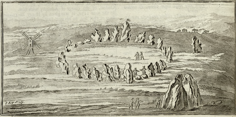
Rollright was first mentioned by the 16-17th century antiquarian William Camden and again later in the 17th century by John Aubrey and Robert Plot. Plot also included a fairly decent illustration by David Loggan of the site (a portion of the drawing showing the King's Men and the King Stone shown below). Loggan appears to show about sixty-five stones of which about half are either standing or leaning while others are just stumps or fragments. His drawing is looking northwest with the presumed entrance just to the left of the centre at the bottom of the image and shows that one of the portal stones (to the left) had fallen by that time. The tallest stone of the circle is drawn almost opposite, to the upper right of centre.
Another antiquarian, William Stukeley, who visited and sketched the site in the mid 18th century was so struck by the blocks of heavily weathered and eroded limestone that he described them as being 'corroded like worm-eaten wood, by the harsh jaws of time', a very apt description. Stukeley also stated that twenty-two stones were still standing in his time and although it is can be risky to rely on such old drawing and accounts, the illustrations by Loggan and Stukeley are similar enough to be taken as fairly accurate depictions of the circle as it was in the 17-18th century. Stukeley's illustration is from almost the same angle as Loggan's, with the entrance and fallen portal just to the left of centre at the bottom of the image.
The circle is difficult to date but was probably constructed during the late Neolithic or early Bronze Age period somewhere between 2500-2000BC. Although the stones appear to stand on a slight bank this is now believed to have been a much later addition, possibly as late as the Roman period.
There are many legends attached to the stones at Rollright, one local tale which dates to as early as 1600 claims a local king was traveling across Oxfordshire with his five knights and army of soldiers. Suddenly he was challenged by an old woman (spoiler alert: she's a witch) who asked of his business, to which he replied 'To conquer England, and rule it as one kingdom'. To this she said -
'Seven long strides more take thee,
And if Long Compton thou canst see,
King of all England thou shalt be'
The king replied to her challenge:
'Stick, stock and stone,
As King of England I shall be known'
In doing so, he took seven mighty strides, but found his view obscured by a mound of earth, the witch now crying aloud-
'Because Long Compton thou canst not see,
King of England thou shalt not be.
Rise up stick, and stand still stone,
King of England thou shalt be none.
Thee and thy men hoar stone shall be,
And I myself an eldern tree'
The king and his men were frozen to stone, and remain there to this day. Another story, common to many circles and burial chambers says that the stones cannot be counted, while it is also said that they go down to the river to drink at midnight (or on New Year's Day), and that if they are removed they will return to their original positions.
Dances and feasts used to be held near the King Stone on Midsummer's Eve and Rollright still appears to be popular with those who hold Pagan beliefs, on one visit a few days after the summer solstice some of the stones showed signs of red candle wax and trees nearby were be-decked with offerings. However sadly both of the photographs on this page (taken several years apart in the 1990's) also show the evidence of scorch-marks from a fire at the centre of the circle.
Rollright is easily accessible and well worth a visit, standing as it does close to the Roman Fosse Way and the beautiful Cotswold towns of Stow-on-the-Wold and Moreton-in-Marsh.
See also: Whispering Knights burial chamber and King Stone standing stone.
The King's Men (photographs above and below, both looking southwest), often just referred to as Rollright Circle is probably one of the most well known and most regularly visited stones circles in England but is unusual as it stands isolated from any other groups of similar monuments, being the only circle in this part of the country. In its present state it consists of around seventy stones (plan left, standing stones drawn in black, fallen stones in grey), some of which are set almost edge to edge in places and which form a 32 metre diameter almost perfect circle. Some of the stones are badly broken and reach only a few centimetres above the grass although others have survived in better condition, particularly in the northern arc where the tallest stone still reaches a height of 2.3 metres. The original number of stones forming the circle is a matter of debate, the author John Barnatt believes it was probably in the region of between sixty-four and ninety although I would estimate that the lower number is more likely. What makes the determination more difficult is that broken fragments of fallen stones were used to fill in the some of the gaps between existing standing stones when the site was partly restored in 1882.
Although there are several large breaks in the ring these are the result of missing stones and the true entrance is probably to the south-southeast where a gap is marked by a pair of portal stones just outside the circle, the one to the east of the entrance is still standing, the one to the west has lain prostrate since at least the middle of the 17th century, interestingly the tallest stone of the circle stands almost opposite this entrance. The modern path shown in these photographs leading into the circle through a gap in the stones to the northeast simply provides convenient access from the road.
Rollright was first mentioned by the 16-17th century antiquarian William Camden and again later in the 17th century by John Aubrey and Robert Plot. Plot also included a fairly decent illustration by David Loggan of the site (a portion of the drawing showing the King's Men and the King Stone shown below). Loggan appears to show about sixty-five stones of which about half are either standing or leaning while others are just stumps or fragments. His drawing is looking northwest with the presumed entrance just to the left of the centre at the bottom of the image and shows that one of the portal stones (to the left) had fallen by that time. The tallest stone of the circle is drawn almost opposite, to the upper right of centre.
Another antiquarian, William Stukeley, who visited and sketched the site in the mid 18th century was so struck by the blocks of heavily weathered and eroded limestone that he described them as being 'corroded like worm-eaten wood, by the harsh jaws of time', a very apt description. Stukeley also stated that twenty-two stones were still standing in his time and although it is can be risky to rely on such old drawing and accounts, the illustrations by Loggan and Stukeley are similar enough to be taken as fairly accurate depictions of the circle as it was in the 17-18th century. Stukeley's illustration is from almost the same angle as Loggan's, with the entrance and fallen portal just to the left of centre at the bottom of the image.
The circle is difficult to date but was probably constructed during the late Neolithic or early Bronze Age period somewhere between 2500-2000BC. Although the stones appear to stand on a slight bank this is now believed to have been a much later addition, possibly as late as the Roman period.
There are many legends attached to the stones at Rollright, one local tale which dates to as early as 1600 claims a local king was traveling across Oxfordshire with his five knights and army of soldiers. Suddenly he was challenged by an old woman (spoiler alert: she's a witch) who asked of his business, to which he replied 'To conquer England, and rule it as one kingdom'. To this she said -
'Seven long strides more take thee,
And if Long Compton thou canst see,
King of all England thou shalt be'
The king replied to her challenge:
'Stick, stock and stone,
As King of England I shall be known'
In doing so, he took seven mighty strides, but found his view obscured by a mound of earth, the witch now crying aloud-
'Because Long Compton thou canst not see,
King of England thou shalt not be.
Rise up stick, and stand still stone,
King of England thou shalt be none.
Thee and thy men hoar stone shall be,
And I myself an eldern tree'
The king and his men were frozen to stone, and remain there to this day. Another story, common to many circles and burial chambers says that the stones cannot be counted, while it is also said that they go down to the river to drink at midnight (or on New Year's Day), and that if they are removed they will return to their original positions.
Dances and feasts used to be held near the King Stone on Midsummer's Eve and Rollright still appears to be popular with those who hold Pagan beliefs, on one visit a few days after the summer solstice some of the stones showed signs of red candle wax and trees nearby were be-decked with offerings. However sadly both of the photographs on this page (taken several years apart in the 1990's) also show the evidence of scorch-marks from a fire at the centre of the circle.
Rollright is easily accessible and well worth a visit, standing as it does close to the Roman Fosse Way and the beautiful Cotswold towns of Stow-on-the-Wold and Moreton-in-Marsh.
See also: Whispering Knights burial chamber and King Stone standing stone.

Rollright circle in late afternoon flat light.

This illustration of the King's Men circle with the King Stone to the upper right appears at the end of Robert Plot's 'Natural History of Oxfordshire' 1677, but I believe was drawn by David Loggan. The view is looking northwest, the presumed original entrance is the group of four stones to the left of the centre in the lower arc of stones with one of the two portal stones that stood just outside the entrance shown to have already fallen by this time.

William Stukeley's drawing of Rollright Circle 1743, looking north-northwest from close to the original entrance (to the right of the figure) with its pair of external portal stones, the one to the left laying fallen. Stukeley referred to the site as 'Rowldrich', another old spelling being 'Rolldrich' both of which come down from the name 'Rollandri' recorded in the 11th century Domesday book as the name of the nearby Little and Great Rollright villages.

Before and after restoration - two 19th century plans of the King's Men stone circle at Rollright with the tallest stone ringed in green and the original entrance ringed in red. The image to the left is credited to Dryden and Lukis 1840, reproduced by O. G. S. Crawford, the image to the right is from Evans 1895 and is credited to H. Hurst - I've removed most of the text from this second image for clarity. The plans, to the same scale and orientation, show the how the condition of the circle changed after the restoration of 1882, albeit assuming the accuracy of both drawings. The 1840 plan appears to show fifty-four stones (or fragments of stones) in total, several of which are fallen, the 1895 plan shows seventy-one but only three fallen with stones having been re-erected and gaps (particularly to the west) being filled with other broken fragments of stone - this is about how the circle appears today.

Satellite image showing the layout of the three groups of monuments at Rollright.
Additional Notes:
Camden's account of Rollright was originally published in Latin in the Oxfordshire section of his 'Britannia: or a Chorographical Description of Great Britain and Ireland, Together with the Adjacent Islands' which appeared in several revised and expanded editions towards the end of the 16th century and was then re-published by various authors as an English translation in later centuries. This version comes from Edmund Gibson's translation of 1722.
'...a great monument of Antiquity ; a number of vastly large Stones plac’d in a circular figure, which the Country-people call Rolle-rich-stones, and have a fond tradition, that they were once Men, and were turn’d into Stones. The figure of them, as rudely drawn a long time ago, I shall here represent to the Reader’s eye. They are irregular and of unequal height, and by the decays of time are grown ragged and very much impair’d. The highest of them, which lies out of the ring toward the east, they call The King ; because they fancy he should have been King of England, if he could have seen Long-Compton, a Village which is within view at a very few steps farther ; five larger Stones, which on one side of the circle are contiguous to one another, they pretend were Knights or Horsemen, and the other common Soldiers.'
The next section is a later addition and appears to taken from Plot and Aubrey:
'It is a single Circle of Stones without Epistyles or Architraves, and of no very regular figure. Except one or two, the rest of them not above four foot and a half high. What the occasion of this Monument might be, is not hinted by any Inscription upon the Stones, nor by any other marks about them : which seems to make it probable at least, that it was not erected in memory of any persons that were bury’d there. For, if so, we might expect (as in other places of this kingdom) to meet with a Cross or something of that kind implying the design, if Christian ; or, if Pagan, we might expect to find barrows at some small distance. Besides, a curious Antiquary in these parts, making a diligent search, in the middle, for some Remains which might lead us to the first design, and particularly for bones ; found himself disappointed. Tho’, if we may take an estimate of this, from another of the like nature, the bones (if there are any) may more probably be met with, without the circle, as they were found some years ago at a little distance from that at Kynet in Wiltshire, and have been formerly found at the famous Stonehenge.'
Finally, Camden himself again:
'One may then imagin this Monument to have been rais’d in memory of some victory obtained here, perhaps by Rollo the Dane...'
Camden was wrong in his guess that the stones were erected by the Vikings (presumably the thought Rollo was the etymological root of Rolle-rich) but such beliefs about a Dark Age origin of what we now know are prehistoric monuments were widespread in his time, and even later, however whoever wrote the addition was correct in the assertion that the circle was not a funerary monument.
The 'Anitquary' mentioned in the addition was Ralf Sheldon who Plot informs us 'industriously dug in the middle of it' looking for 'any symbols or marks, either who might erect it, or for what end or purpose' but apparently without result, sometime in the mid 17th century. (Plot. 1677, p338).
The line that mentions 'Epistyles or Architraves' is again from Plot and is presumably commenting that the stones at Rollright have no lintels such as those that form the trilithons of Stonehenge.
The illustration is by William Kip and would win no prizes for accuracy but it does at least show the three components of the site, the circle, the burial chamber and the standing stone albeit not in their correct positions or to scale. It shows the taller stones along the north-western arc of the circle and interestingly does include at least one of the portal stones (to the left of the two figures on the lower edge of the circle). Depending on how we interpret the drawing the second portal stone is either omitted in its fallen state or is shown as still standing around the turn of the 17th century.
Site Visits / Photographs:
June 1992, August 1997.
References:
Barnatt, J. 1987. The Design and Distribution of Stone Circles in Britain... Thesis, (PhD). University of Sheffield.
Burl, A. 1976. The Stone Circles of the British Isles. London: Yale University Press.
Burl, A. 1979. Rings of Stone. London: Frances Lincoln Publishers Ltd.
Burl, A. 1995. A Guide to the Stone Circles of Britain, Ireland and Brittany. London: Yale University Press.
Burnham, A. (Ed.). 2018. The Old Stones ...Megalithic Sites of Britain and Ireland. London: Watkins
Camden, W. 1722. Britannia. Gibson Edition Vol 1. London.
Crawford, O. G. S. 1925. The Long Barrows of the Cotswolds. Gloucester: John Bellows.
Cope, J. 1998. The Modern Antiquarian. A Pre-Millennial Odyssey through Megalithic Britain. London: Thorsons.
Dyer, J. (Editor). 1993. Discovering Prehistoric England. Princes Risborough: Shire Publications Ltd.
Evans, A. 1895. The Rollright Stones and their Folklore. Folk-lore, Vol 6, 6-51.
Ferguson, J. 1872. Rude Stone Monuments in all Countries; their age and uses. London: Murray.
Marshall, S. 1981. Everyman's Book of English Folk Tales. London: J. M. Dent & Sons Ltd.
Michell, J. 1982. Megalithomania. Artists, antiquarians and archaeologists... London: Thames and Hudson.
Plot, R. 1677. The Natural History of Oxfordshire. Oxford:
Rickett, F. nd. The Rollright Stones: History & Legends... Chipping Norton: Simms.
Stukeley, W. 1743. Abury, A Temple of the British Druids, with Some Others, Described. London:
Taunt, H. c1907 The Rollright Stones; The Stonehenge of Oxfordshire. Oxford: Taunt and Co.
Thom, A. 1967. Megalithic Sites in Britain. London: Oxford University Press.
Historic England Research Records: Hob 968686.
NMR Number SP 23 SE 29 (King's Men)
NMR Number SP 23 SE 14 / 28160 (Rollright Stones).
Pastscape Monument Number 332813 (Rollright Stones).