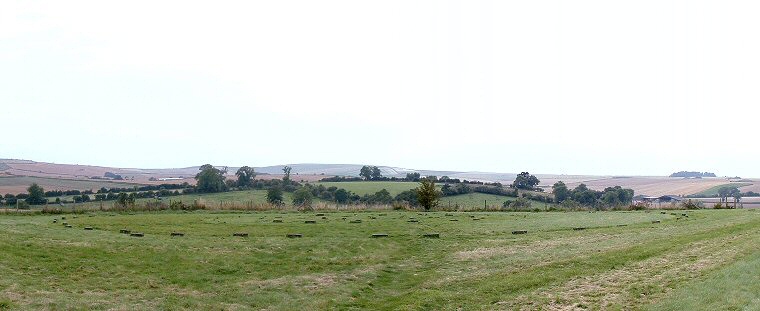
 View looking southwest over the concrete blocks that mark the stone and post holes of The Sanctuary. |
Overton Hill marks the southern end
of The Ridgeway, an ancient track that runs northeast across the North Wessex
Downs and the Chilterns as well as the site of the Overton Hill barrow group. It also marks what would have been the start of the West
Kennet Avenue, the double stone row that leads into Avebury.
During the late Neolithic, around 2500BC and at about the same time as work was taking place on the Avebury earthwork,
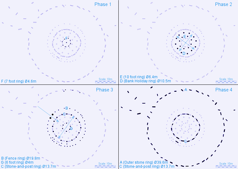
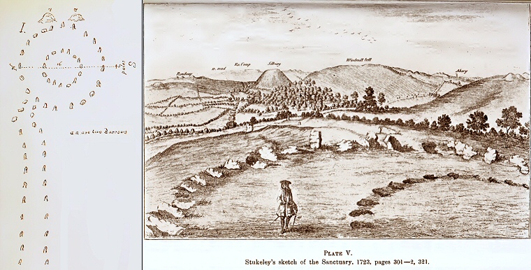
a complex series of concentric timber and stone circles began to be constructed on this hill. The existance of two rings of stones about 5 feet (1.5 metres) tall was first recorded by John Aubrey in the late 17th century and then again by William Stukeley who sketched the site in 1723-1724 and documented the ongoing removal of the stones by a farmer Green. At the time Stukeley recorded the outer circle of consisting of eighteen stones of which all but three were fallen and an inner circle which also consisted of eighteen stones, presumably all fallen. He also stated that the circles had been almost complete and standing within living memory and that their removal was much lamented by the locals who he claimed knew the site by the name of 'The Sanctuary'. The site lay lost and forgotten until the early 1930's when it was rediscovered and excavated by Maud Cunnington who as well as relocating the stone holes of the two stone circles also uncovered five further concentric rings of holes which she assumed to have held wooden posts. She interpreted these rings as belonging to four phases of building and enlargement at the site spanning several hundred years, the first two phases in timber the third in timber and stone and the final phase being the outer ring of stone. Furthermore the layout of the holes suggest that earlier structures, or at least their rotting wooden posts, were still in place as each successive new phase of construction began. Archaeological opinion is divided on whether the timber phases can be interpreted as free standing structures, perhaps painted and carved or holding lintels, or whether they represent the supports of roofed buildings. Following Cunnington's four phase model the first phase of construction on Overton Hill consisted of a 4.5 metre diameter ring of eight posts surrounding a single central post. The dimensions of this central post hole suggested the post it contained was only slender and Cunnington felt that this may have been used as a centre point for the subsequent laying out of the site rather than supporting a roof. Later this first structure seems to have been replaced, or augmented by two more rings of larger posts, the inner ring had eight posts, the outer ring had twelve and a diameter of some 10 metres. The structure may have been laid out in the form of a cross with one axis running northeast to southwest and the other southeast to northwest (see plan below). By the third phase the structure had become more elaborate, this time consisting of three rings of concentric posts. An inner ring of six posts was placed between the positions (or former position) of the posts of phase one but with a gap left to the northeast and southwest. A ring of sixteen large posts were added about a couple of metres beyond those of the second phase with their positions suggesting a single axis of northeast to southwest. Cunnington noted that the third outer ring consisted of much smaller post holes except for a larger pair to the northwest (on the southeast to northwest axis) which she speculated may have acted as a gateway or entrance with the smaller posts supporting a fence, the diameter of the site now approaching 20 metres. The final phase sees a move from timber to stone. Sixteen sarsen stones were placed precisely between the location of the timbers of the middle ring of phase three (indeed they may have been contemporary with that phase) and the site was then massively enlarged with the inclusion of a 40 metre diameter outer ring of forty-two stones. In the northwest quadrant Cunnington located six further stone holes that she believed formed the start of the two rows of the West Kennet Avenue that winds down Overton Hill before skirting the lower slopes of Waden Hill on its journey towards the south-eastern entrance to Avebury. A further two stone holes just to the north may suggest an earlier or abandoned row. The location of a single stone was found just to the southwest of the inner circle, this was flanked by two pairs of post holes and a couple of seemingly randomly placed stone holes were found just to the east of the outer circle. Finds of human remains from the site were scarce, apart from three pieces of jaw bone from one of the stone holes a single burial of a youth aged about 14-15 years old was found on the inside edge of the easternmost stone of the inner stone circle. This burial is believed to belong to the very late history of the site, possibly after it had fallen out of use and probably dates from around 2000BC. Interpretations of both the form of The Sanctuary and its function have varied since the 1930's and in an attempt to clear up some of the uncertainty arising from Maud Cunnington's report a 25 square metre area of the inner timber rings was re-excavated in 1999 by Mike Pitts. He was conclusively able to show that some of the post holes had been dug, refilled and dug again in rapid succession which would probably argue against the posts having supported the roof of a permanent building. He further suggested that the construction, removal and reconstruction of the timber rings was more likely to have been viewed by the Neolithic builders as an ongoing operation whose meaning and symbolism lay in the repeated building process itself rather than the end result. However it could be argued that the transient nature of the site came to an end in Phase 4 with a desire for permanence resulting in the decision to build in stone rather than timber. The builders got their wish for around 4000 years until the actions of farmer Green in the early 18th century removed all remaining surface traces of The Sanctuary from Overton Hill, all that stands today on this enigmatic site are a series of concrete markers showing the former position of the circles. See also the timber circle of Woodhenge near Stonehenge. |
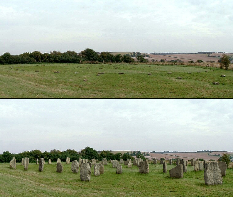
 Two views of The Sanctuary - as it is now and as it would have been it the stones had remained standing. The view is looking southeast with the stones that mark the beginning of the West Kennet Avenue to the right of the image. |
 Plan of The Sanctuary broken down into four possible phases for clarity, the first three in timber, the last in stone although it is by no means certain that this was the actual sequence of building. I've used Maud Cunnington's naming scheme for the rings of a letter and a descriptive name followed by the diameter of each ring converted to metres. Phase 2 appears to me to have two axes or sight-lines through the rings (marked as blue arrows). The two inner rings of Phase 3 appear to have a single axis while the outer ring has a pair of larger postholes to the northwest which may have formed a gateway or entrance through the outer and middle rings. This is almost down the centre-line of the three rows of stones that radiate from the northwest of the outer circle in Phase 4, however the lower two rows are thought to be part of the West Kennet Avenue while the purpose of two stones above them is unknown but may indicate that an earlier entrance to the site was aligned on the timbers of Phase 3. |
 The antiquarian view. Left: John Aubrey visited and sketched the site in the mid-late 17th century, he depicted the concentric stone circles as well as the course of the West Kennet Avenue which he gave a pronounced kink in an attempt to correct the discrepancy between the orientation of the stones emerging from The Sanctuary and those of the Avenue itself. Right: Stukeley provided a more detailed illustration which records the ongoing destruction of the site in 1724. In this drawing looking northwest towards Silbury and Windmill Hill he depicts the empty stone holes of the inner circle and while the outer ring appears to be more or less complete, all but a handful of the stones were fallen by this time. He also shows that only a few of stones of the Avenue remained as it descends Overton Hill but many more were still standing on the final approach into Avebury towards the upper right of the drawing. |
Site Visits / Photographs: August 1997, September 2002. References: Barnatt, J. 1987. The Design and Distribution of Stone Circles in Britain... Thesis, (PhD). University of Sheffield. Burl, A. 1979. Prehistoric Avebury. London: Yale University Press. Cunnington, M. 1932. The "Sanctuary" on Overton Hill... Wiltshire Archaeological & Natural History Magazine, 45, 300-335. Cunnington, M. 1949. An Introduction to the Archaeology of Wiltshire. 4th Edition. Devizes: Charles Henry Woodward. Gibson, A. 2005. Stonehenge and Timber Circles. New Edition. Stroud: Tempus Publishing Ltd. Malone, C. 1994. The Prehistoric Monuments of Avebury. London: English Heritage. Piggott. S. 1939. Timber Circles: A re-examination. Archaeological Journal, Vol 96, 193-222. Piggott, S. 1950. William Stukeley: An Eighteenth-Century Antiquary. Oxford: Clarendon Press. Pitts, M. 2001. Excavating the Sanctuary... Wiltshire Archaeological & Natural History Magazine, 94, 1-23. Pitts, M. 2001. Hengeworld. London: Arrow Books Ltd. Stukeley, W. 1743. Abury, A Temple of the British Druids, with Some Others, Described. London. |