
Contained within
a giant circular henge
about 430 metres across, the site of Avebury rivals, and some would say
surpasses Stonehenge for its sheer scale
and impressiveness. The antiquarian John Aubrey certainly agreed and wrote
in the mid 17th century - "it does as much exceed in greatness
the so renowned Stonehenge as a cathedral doeth a parish church".
Avebury is certainly calmer and more accessible than Stonehenge as although
the A361 road passes through the middle of village the whole area can
be easily viewed on foot and the visitor is free to wander amongst the
stones.
Constructed towards the end of the Neolithic, probably around 2500BC, the banks of the henge earthwork that surrounds the whole site are still around 5 metres high in places - originally they would have been nearly 7 metres tall, between 20-30 metres thick at the base and enclosed an area of some 30 acres (12ha). Within them an internal flat bottomed ditch that would once have been up to 9 metres deep and over 20 metres wide was cut into the underlying chalk and an estimated 200000 tons of chalk rubble hauled up to construct the bank with the central area of the henge accessible by four entrance causeways over the ditch which are now used by the road and village street. Today this mammoth construction is carpeted in a layer of grass but when built the white of the chalk would have stood out in dramatic contrast to the green of the Marlborough landscape.
Just inside the henge stood about a hundred unworked local sarsen stones ranging in height from 3-6 metres and weighing up to 20 tons that formed the Outer Stone Circle. Many of these stones were pulled down and buried in the 14th century while later William Stukeley recorded that others were broken up in the early 18th century and used for building material as the village grew about them. The monument descended into a sorry state but thanks to the restoration work of Alexander Keiller in the 1930s there are now thirty stones to be seen in this circle, mainly towards the south and northwest (photograph above) with the location of missing stones marked with concrete blocks.
Inside the outer circle stand the remains of the smaller North and South Circles. To the south of the modern High Street the South Circle had a diameter of just over 100 metres and originally contained twenty-nine large stones of which five remain. At its centre a fallen slender pillar known as the Obelisk was recorded by Stukeley but this also fell victim to the 18th century need for building stone and all that remains is the concrete marker erected during Keiller's restoration. Excavations have revealed that the Obelisk was associated with several pits, one of which contained a pottery vessel, and was set within its own rectangular or 'D' shaped stone setting. On the other side of the road the North Circle is thought to have been slightly smaller at just under 100 metres diameter, with an original twenty-seven stones of which only four remain although two of these are now fallen. Within it there was possibly another smaller circle which contained a triangular arrangement of stones known as the Cove - two huge sarsens remain which are amongst the largest of the stones at Avebury, the third stone having fallen and been removed in the 18th century.
Emerging from the southern entrance of Avebury is the West Kennet Avenue which runs 1.5 miles to The Sanctuary on Overton Hill. This would originally have consisted of one hundred pairs of stones facing each other 15 metres apart, each pair consisting of a tall narrow stone opposite a shorter squatter stone - possibly representing male and female symbols. Stukeley recorded another avenue running from the west entrance towards West Down that passed through a pair of large sarsens known as the Longstones, for years this 'Beckhampton Avenue' was disputed but continuing excavations since 1999 have vindicated Stukeley by uncovering several buried stones and stone pits from this western avenue.

Stones of the south-western sector with the southern entrance behind.

The Swindon Stone on the western side of the northern entrance.
 Two standing stones of the Cove in the northeast sector.
Bank and ditch of the northwest sector henge earthworks.

Bing aerial image of Avebury.
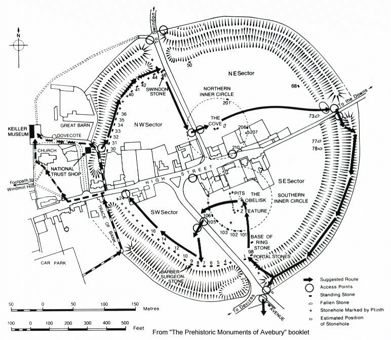 Avebury plan - click to enlarge
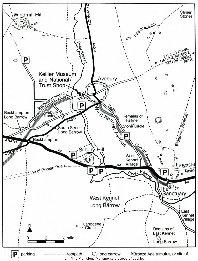 Avebury map - click to enlarge