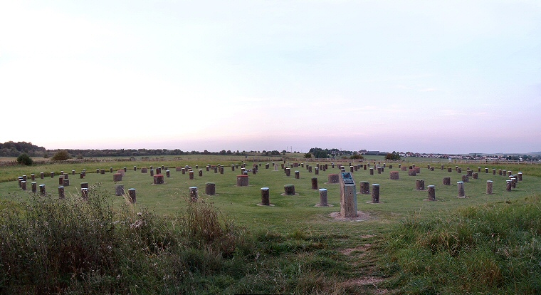
 An evening view of Woodhenge looking northeast. |
| The site now known as Woodhenge located about a hundred metres south of Durrington Walls and 3 kilometres (1.9 miles) east-northeast of Stonehenge was long thought to be the eroded bank of a disc barrow first recorded by Sir Richard Colt Hoare in the early 19th century and known locally as the Dough Cover. However in 1925 RAF pilot Squadron Leader Gilbert Install flew over the site and photographed a series of soil and cropmarks that seemed to form circular concentric rings within the bank. This discovery lead to the site being excavated by Maud and Howard Cunnington between 1926-28 who discovered that the bank was in fact part of a late Neolithic or early Bronze Age henge monument that had enclosed a series of substantial internal wooden structures. The henge earthwork itself has a total diameter of about 85 metres and while the outer bank has been ploughed almost flat and the inner ditch has become infilled over the years, excavation revealed them both to be about 6-10 metres wide with the ditch cut almost 2.5 metres into the chalk and with a single entrance causeway to the north-northeast. What the Cunningtons discovered within the henge was a series of six rings of pits also cut deep into the underlying chalk which formed concentric ovals or egg shapes slightly flattened towards the south-western side, they labeled the rings of pits A to E working inwards from the outer ring (see plan below). These pits were the post holes for a series of upright oak timbers with the outer oval 'ring A' having a diameter of 43 metres by 40 metres and holding sixty small posts. The next two rings inwards had the deepest and widest pits and presumably these held the largest timbers, ring B consisted of thirty-two large posts while ring C held the largest sixteen posts, Maud Cunnington calculated that the tallest of these posts could have stood up to 7.5 metres above ground level. The post holes in rings D, E and F were much smaller and each ring held eighteen, eighteen and twelve posts respectively, all the pits and presumably the timbers, being roughly the same size. 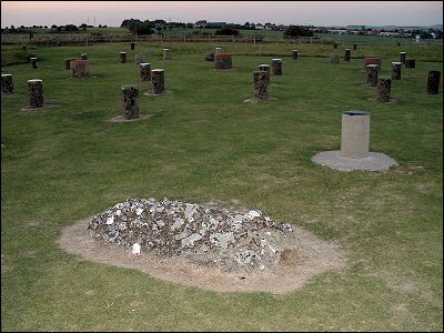 A dozen further small pits were discovered, six around the area occupied by the henge and six holding seemingly randomly placed posts within the timber ovals. Maud had noticed that the long axis of the ovals fell along the line of the midsummer sunrise / midwinter sunset in a similar manner to Stonehenge and Aubrey Burl has speculated that two of these ‘extra’ posts were used to form a narrow corridor sight-line through the monument to allow an observer a view of the sunrise on the summer solstice. Another post could have formed part of a sight-line to the now fallen sarsen monolith of the Cuckoo Stone, 400 metres to the west. A dozen further small pits were discovered, six around the area occupied by the henge and six holding seemingly randomly placed posts within the timber ovals. Maud had noticed that the long axis of the ovals fell along the line of the midsummer sunrise / midwinter sunset in a similar manner to Stonehenge and Aubrey Burl has speculated that two of these ‘extra’ posts were used to form a narrow corridor sight-line through the monument to allow an observer a view of the sunrise on the summer solstice. Another post could have formed part of a sight-line to the now fallen sarsen monolith of the Cuckoo Stone, 400 metres to the west.Towards the centre of the site and along the axis of the midsummer sunrise a pit was found that contained the buried remains of a young child - this spot is now marked by a low flint cairn (image above). When excavated the child’s skull was found to have split into two pieces which lead the Cunningtons to believe that the child had been sacrificed perhaps as a dedicatory offering at the construction of the timber monument. However it is now thought the child’s still growing skull probably separated naturally under the weight of earth after burial and as the skeleton was lost when the Royal College of Surgeons was bombed during the Second World War and cannot be re-examined, it is something that can sadly never be resolved. Recent re-interpretation of the grave also suggests that the burial was a later addition to the site, perhaps in the early Bronze Age when the timbers had already decayed. The Cunningtons also found the skeletal remains of a young man buried in a grave within the henge ditch towards the entrance as well as cremation remains in one of the post holes which have since been dated to between 2580-2470BC. As well as bones from wild and domestic animals they also recovered several carved chalk axes and cups - the axes would have no practical use and were interpreted as ritual objects and it is further suggested that objects were buried in deliberately selected areas of the site in a form of symbolism known as ‘structured deposition’. What this symbolism was however remains unclear although it could be related to astronomical events such as sun rises and sets at significant times throughout the year. The presumed entrance to the timber circle is aligned slightly further to the north than the entrance to the henge and it is thought that the henge earthworks were a later addition to the site. Also assumed to be slightly later than the timbers were a pair of large sarsen standing stones that were placed between posts in rings B and C towards the south of the structure - both of these stones are now long gone. A re-excavation of this area of Woodhenge in 2006 would discover a further two stone holes which has lead to the speculation that together they formed some kind of three sided stone setting or cove. Whether the wooden posts were still standing or had rotted when the stones were placed here is not known but the fact that the two sarsens stood between a pair of post holes suggests the location of the posts was known to whoever erected the stones. Radio-carbon dating of deer antler picks used to excavate the ditch and finds of Grooved Ware pottery in pits beneath the bank suggest Woodhenge was probably in use between 2500BC - 2000BC with the timber ovals being constructed first and probably decayed and fallen by the time the henge ditches were dug and the banks thrown up. The post holes of Woodhenge are now marked by colour coded concrete blocks giving some indication of their size but whether these posts formed the supports of a building or were freestanding, perhaps being carved and painted, is not known and is still disputed by archaeologists. The reconstructions below show one interpretation of the site with a continuous ring of timber lintels linking the posts of rings B and C. Additional Notes: Dr. Alex Gibson (2012) has proposed the following chronology for the site. The first phase of construction was the inner three rings of small posts (Cunnington's rings D, E and F), these had then decayed or had been removed to be replaced by the outer three rings A, B and C, the orientation of the post ramps used to insert the large timbers of ring C suggesting that the smaller inner rings would have impeded their erection if they had been present. Later he proposes that these outer rings were replaced by the stone setting towards the south of the monument. The henge earthwork was the final phase of construction with possibly a low mound towards the centre which covered the child burial. He places the body in the henge ditch as a later intrusive early to middle Bronze Age burial dated to between 1800-1600BC. This phasing of the construction of the monument is similar to that proposed for the timber and stone circle of The Sanctuary near Avebury. |
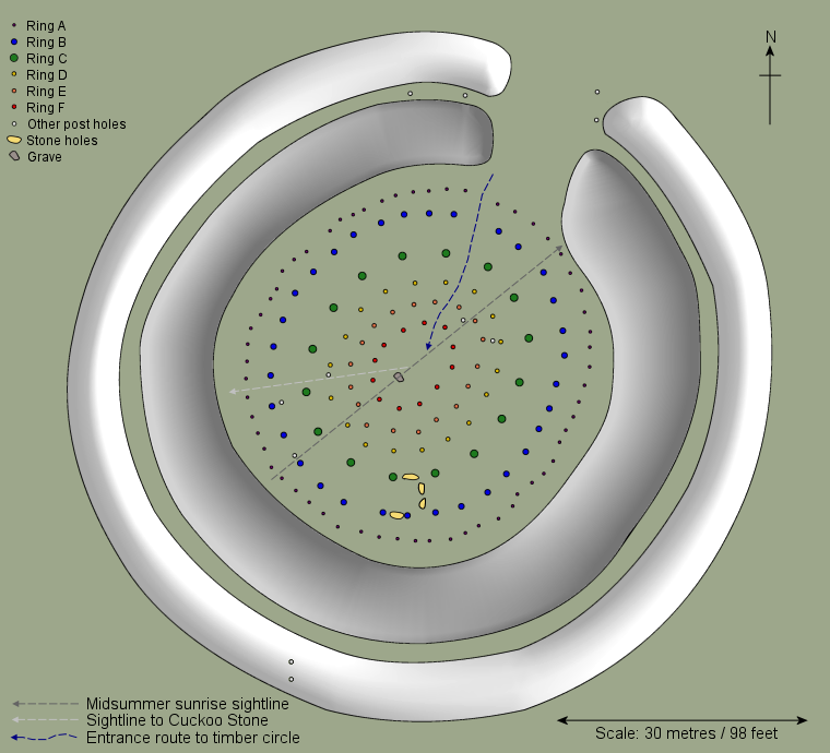 Site plan of Woodhenge based on Cunnington, Burl and Parker Pearson. |
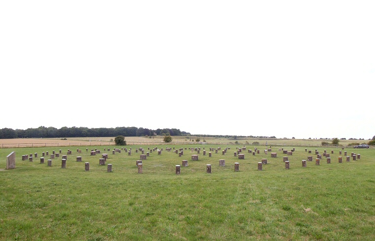 A daytime view taken a decade later, looking north with Durrington Walls visible on the horizon. A daytime view taken a decade later, looking north with Durrington Walls visible on the horizon.
|
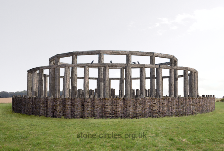 Woodhenge reconstructed - taken from the same angle as the photograph above. Here the outer post ring supports a wattle fence, rings B and C hold large uprights linked by a continuous ring of lintels while the inner three rings contain simple unlinked timber posts. |
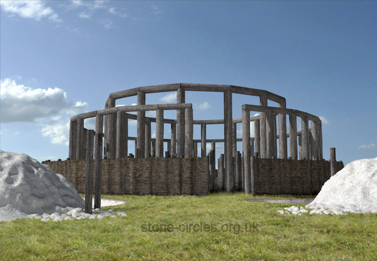 Reconstruction of Woodhenge looking through the causeway of the freshly cut henge bank and ditch. In reality the posts of the circle may have decayed and fallen by the time the henge was built. |
|
360 Degree
Panorama and Reconstructions
|
Site Visits / Photographs: September 2002, July 2011. References: Bradley, R. 2007. The Prehistory of Britain and Ireland. Cambridge: Cambridge University Press. Burl, A. 1989. The Stonehenge People. London: Barrie & Jenkins Ltd. Burl, A. 1997. Prehistoric Henges. Princes Risborough: Shire Publications Ltd. Burl, A. 2007. A Brief History of Stonehenge. London: Robinson. Cunnington, M. 1949. An Introduction to the Archaeology of Wiltshire. 4th Edition. Devizes: Charles Henry Woodward. Exon, S., Gaffney, V., Woodward, A. and Yorston, R. 2000. Stonehenge Landscapes. Oxford: Archaeopress Gibson, A. 2005. Stonehenge and Timber Circles. New Edition. Stroud: Tempus Publishing Ltd. Goddard, E. 1914. List of Prehistoric, Roman and... Wiltshire Archaeological & Natural History Magazine, 38, 248. Lawson, A. 2007. Chalkland: an archaeology of Stonehenge and its region. Salisbury: The Hobnob Press. Parker Pearson, M. 2012. Stonehenge. London: Simon & Schuster UK Ltd. Parker Pearson, M. et al. The Stonehenge Riverside Project - Summary Interim Report on the 2006 season. Piggott. S. 1939. Timber Circles: A re-examination. Archaeological Journal, Vol 96, 193-222. Pitts, M. 2001. Hengeworld. London: Arrow Books Ltd. Additional notes: Gibson, A. 2012. An Introduction to the Study of Henges: Time for a Change? In: Gibson, A. (Ed.) Enclosing the Neolithic: Recent studies in Britain and Europe. Oxford: Archaeopress. BAR International Series 2440: 1-20. Pastscape: 219050, NMR Number: SU14 SE6, Goddard: Durrington 65b, Colt Hoare: Durrington 123. |
