There are around a dozen
stone
circles on Bodmin Moor, including Trippet Circle,
a circle set within a henge at the Stripple Stones, the line of three rings that form the easily accessible Hurlers Circles to the largest ring in Cornwall at Fernacre, located just over a mile (1.8km) across sometimes treacherous moorland to the east. Remarkably however the circle at Stannon, situated on the gentle northern slopes of Dinnever Hill on the north-western edge of the Moor was not recorded before the end of the nineteen century.
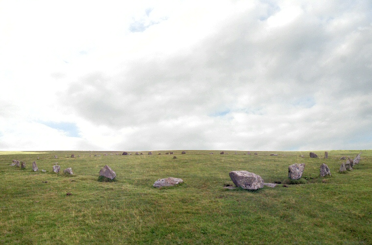
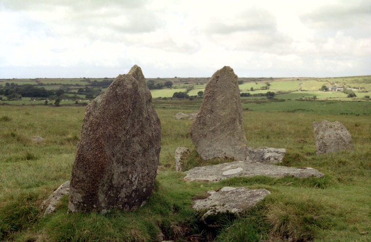
The ring consists of between seventy to eighty granite blocks varying in height from about 30cm to 1.2 metres, some set close together, others further apart and arranged so that the largest stones are located towards the west and southwest. The confusion about the actual number of stones seems to come from the fact that some of the smaller ones may be packing or chocking stones designed to support other orthostats rather than being true uprights themselves.
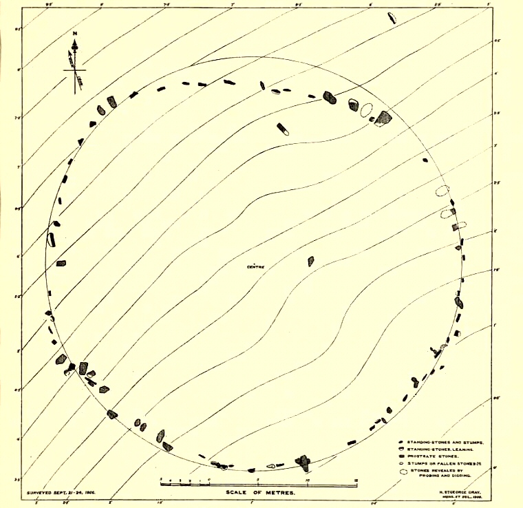
About forty of the stones are still standing set within an impressive 43 metre by 39 metre irregular ring. Just how irregular can be seen from Harold St. George Gray's plan of the circle from 1908 reproduced below which shows the entire northern arc flattened inwards to an almost straight run of stones. The stones of the south-eastern and south-western arcs curve inwards slightly and there is a pronounced gap towards the northeast of the circle. Some of these stones in this quadrant may have been lost over time but it is also possible that an entrance may once have existed here, indeed it is said that the Mayday sun rises over the prominent rock outcrop of Rough Tor just over a mile away to the east-northeast and the gap through the stones may exist to reference this alignment. What is clear however is that true circularity of the ring at Stannon was not the overriding concern of the circle builders, the impression instead is that of an area set aside and enclosed as separate from the everyday world.
Stone circle expert Aubrey Burl draw parallels between both Stannon and the very similar Fernacre circle with the large open rings of Cumbria, based on their large diameters and number of stones (and I would add, aspect) which suggests to him that they may have been constructed earlier than the other circles of the moor and if they are contemporary with the Cumbrian circles this perhaps pushes their age back from the assumed Bronze Age into the late Neolithic. Curiously the flattened northern sector of Stannon also mirrors that of the circle at Long Meg and her Daughters. Is this a coincidence or a deliberate symbolism that is now lost to us?
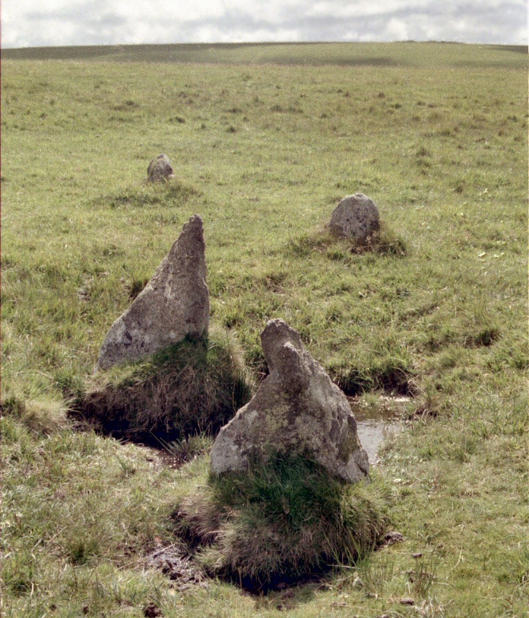
About 80 metres to the northwest of the circle is a group of four stones in a rough line spread over about 6 metres. These are believed to form part of a mostly destroyed stone row that stretched for at least 140 metres in a north-northwest to south-southeast alignment. These four stones (photograph at the bottom of the page) stand at the northern end of the alignment and may represent the remnants a double row of parallel stones. After a gap of about 60 metres the row continues as a single row of seven more widely stones. What the relationship of the row to the stone circle is, is not known although the chronology of stone rows would seem to place their construction towards the middle of the Bronze Age suggesting that the Stannon row was a later addition to the landscape and as it is not aligned on the circle but instead skirts its western edge it may be largely unrelated to the circle itself which the row builders may have regarded as a relic of a bygone age.
At the time I visited Stannon in the late 1990's the area to the north of the circle, just beyond the track, was dominated by the vast Stannon china clay quarry and its associated industrial buildings and spoil heaps which I managed to keep out of my photographs. Current satellite imagery however shows that this blot on the landscape has now been mostly cleared away and grassed over, the actual quarry being turned into a large lake or reservoir.
In my original notes for Stannon I wrote -
Stannon Circle seems to be mentioned in few books of archaeology or antiquity. Why this should be is a mystery, it could be this site's remoteness that see's it excluded from guide books, but that is part of its charm - the only other creatures you are likely to encounter here are the sheep and wild horses of the moor.

Some of the larger stones towards the southwest of Stannon Circle.

Harold St. George Gray's plan of Stannon Circle in 1908, the length of the scale bar is 20 metres. Gray was unable to say if the two stones within the circle itself were original or had been placed there later. The relationship of the circle to the stone that stands a short distance to the northeast is not clear, is this an outlier or a later addition?

These four stones stand about 80 metres to the northwest of Stannon Circle and are thought to represent the remaining northern end of a stone row that extends about 140 metres - what its original length was is not known. They would seem to form a double row at this end, the two larger stones in the foreground representing the eastern lines, the two smaller stones a parallel western line with the row running obliquely from the lower right to mid left of the picture. View looking south.
Site Visits / Photographs:
August 1999.
References:
Barnatt, J. 1987. The Design and Distribution of Stone Circles in Britain... Thesis, (PhD). University of Sheffield.
Burl, A. 1976. The Stone Circles of the British Isles. London: Yale University Press.
Burl, A. 1995. A Guide to the Stone Circles of Britain, Ireland and Brittany. London: Yale University Press.
Burnham, A. (Ed.). 2018. The Old Stones. Field Guide...Megalithic Sites of Britain and Ireland. London: Watkins.
Cope, J. 1998. The Modern Antiquarian. A Pre-Millennial Odyssey through Megalithic Britain. London: Thorsons.
Darvill, T. 2010. Prehistoric Britain. 2nd Edition. Abingdon: Routledge.
Gray, H. 1908. On the Stone Circles of East Cornwall. Archaeologia, 61, 1-60.
The Stone Rows of Great Britain (Website). 2018. Stannon.
Thomas, N. 1976. A Guide to Prehistoric England. London: Book Club Associates.
Weatherhill, C. 1985. Cornovia. Ancient Sites of Cornwall & Scilly. Penzance: Alison Hodge.
Historic England Research Records Hob Uid: 434396. NMR: SX 18 SW 2. (Stone Circle)
HER Number: 3352. Scheduled Monument: 15280. (Stone Row)