
Trippet Stone Circle looking east towards Hawk's Tor
The Trippet Stones are located towards the western edge of the moor of the flat plateau of land of Manor Common bounded to the north by the nearby Carbilly Tor and Hawk's Tor and more distantly to the south by the Trehudreth Downs and Temple Tor. The site was first recorded by John Thomas Blight in 1858 who noted nine standing stones as well as two other stones lying prostrate along the line of the circumference of the circle but for some reason he failed to realise they actually formed part of the circle. In the following few years the stones were visited by several antiquarians including the Reverend Lukis, W. C. Borlase and G. F. Tregelles and it was noted that by 1891 one of the stones had fallen.
In the early years of the 20th century an accurate plan of the circle was drawn up by Harold St. George Gray during his first visit to the site (shown below). Gray showed that the remaining stones stood along the line of a perfect circle just under 33 metres in diameter and calculating the average distance between the stones as 3.9 metres estimated that the original number of stones within the circle would have stood at twenty-six. Given that he could only find twelve stones on site, eight standing and four fallen (and discounting a modern boundary marker) this meant that over half of the stones had been lost, or to put it more succinctly in Gray's words 'pillaged', over time, no doubt broken up for use in buildings or field walls.
The site remained in a similar condition for nearly a century, consisting of the eight upright smooth granite blocks measuring between about 1.2 metres and 1.4 metres tall along with their four fallen compatriots with the most complete sections being the northeastern arc of three uprights linked a pair of fallen stones. The remaining uprights are fairly evenly spaced between the southeast and northwest and together the stones form what stone circle expert Aubrey Burl once described as 'one of the most attractive circles in the British Isles'.
However years of cattle, sheep and horses using the stones as convenient rubbing posts combined with the stones shallow pits and the soft peat of the moor had resulted in large areas of erosion around the stones (see image below) and caused some of them to lean badly. Remedial work was carried out first in 1999 and again in 2003 to try to consolidate four of the stones and prevent further deterioration of the site by infilling the eroded pits with loose stone and then capping them with a fresh layer of turf. In 2006 this work continued around a further three stones and culminated in re-erecting the fallen stone that lies at the west of the circle.
The close proximity of prominent rock outcrops has lead to several astronomical alignments to be suggested for the Trippet Stones including the setting of the midsummer sun behind Carbilly Tor when seen from the circle. In 1907 the astronomer Sir Norman Lockyer proposed that the star Arcturus, which forms part of the Boötes constellation, would have risen over the distant Rough Tor in about 1700BC. Alternatively Alexander Thom interpreted that an alignment from the circle through an outlying stone indicated the setting of Castor, one of the stars of the Gemini constellation in 1840BC. Aubrey Burl dismisses both dates and places the Trippet stones about 500 years earlier, towards the beginning of the Bronze Age. Attempting to ascribe alignments of stones with stars or landscape features is always a contentious issue, draw a line between two objects and they are almost certain to point to a rising or setting star at some point in time, solar or lunar alignments are often much more convincing.
In my original notes for Trippet Circle I wrote -
The whole of this area is very open and cattle roam freely around the site. This has lead to moats of water around the stones where animals have used them as scratching posts. Indeed, when I visited Trippet a worryingly large bull with a rather dangerous looking pair of horns showed a little too much interest, leading to an unscheduled early exit from the site!
The name 'Trippet' may come from the belief that the circle was the petrified remains of a group of women turned to stone as a punishment for dancing on the Sabbath.

A view looking southeast across the circle showing the erosion damage caused by cattle and horses using the stones as rubbing posts. The low stone between the two circle stones is the modern boundary marker.
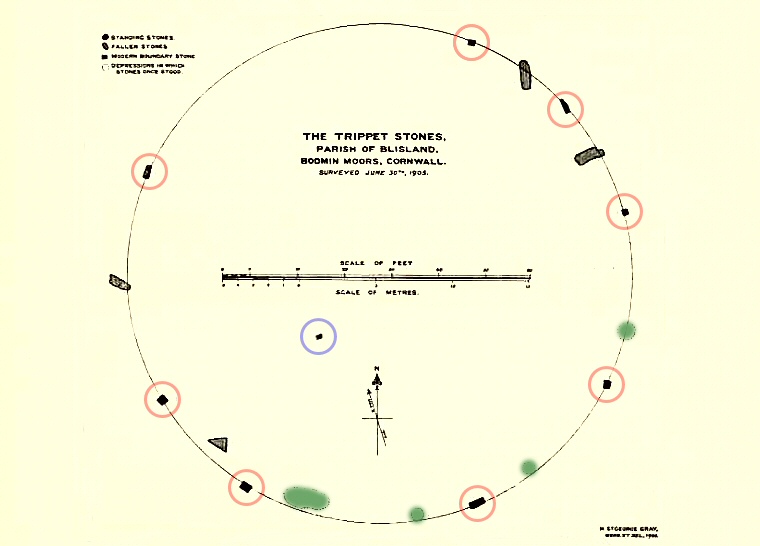
Harold St.George Gray's plan of the Trippet Stones surveyed in 1905 and published in 1908, the length of the scale bar is 20 metres. I've marked the standing stones with red circles for clarity, the boundary marker is ringed in blue. Gray suggested several pits (marked in green) were the sites of former stone that were already missing by his time. The stone that was re-erected in 2006 is the fallen stone at the west of the circle.
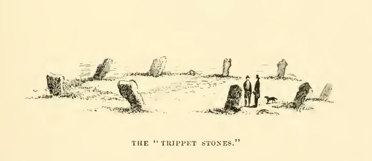
J. T. Blight's sketch of the Trippet Stones published in 1858. Blight doesn't give us much information about the site which is surprising for as far as archaeology is concerned, he 'discovered' it, although it was obviously known locally as at least half the stones had been robbed from the site before his time. He says the circle consists of nine upright stones but he seems to dismiss a pair of fallen stones lying on the circumference of the circle. Interestingly he doesn't show the boundary stone within the circle.
Site Visits / Photographs:
August 1999.
References:
Barnatt, J. 1987. The Design and Distribution of Stone Circles in Britain... Thesis, (PhD). University of Sheffield.
Blight, J. T. 1858. Ancient Crosses and other Antiquities in the East of Cornwall. London: Simpkin, Marshall and Co.
Burl, A. 1976. The Stone Circles of the British Isles. London: Yale University Press.
Burl, A. 1979. Rings of Stone. London: Frances Lincoln Publishers Ltd.
Burl, A. 1995. A Guide to the Stone Circles of Britain, Ireland and Brittany. London: Yale University Press.
Cope, J. 1998. The Modern Antiquarian. A Pre-Millennial Odyssey through Megalithic Britain. London: Thorsons.
Dyer, J. (Editor). 1993. Discovering Prehistoric England. Princes Risborough: Shire Publications Ltd.
Gossip, J. 2007. The Trippet Stones, Blisland, Cornwall. Erosion Repair. Cornwall County Council.
Gray, H. 1908. On the Stone Circles of East Cornwall. Archaeologia, 61, 1-60.
Ridpath, I. and Tirion, W. 2000. Collins Gem Stars. Glasgow: Harper Collins.
Weatherhill, C. 1985. Cornovia. Ancient Sites of Cornwall & Scilly. Penzance: Alison Hodge.
Historic England Research Records Hob Uid: 433066. NMR Number: SX 17 NW 8.