 |
| Thought to be
one of the oldest stone
circles in Britain and probably dating from either the late Neolithic
or early Bronze
Age, Castlerigg or 'The Carles' stands on a plateau of land between the River Greta to the north and Naddle Beck to the east and set within
a natural amphitheatre of Lakeland hills that give it what must be one of the
finest settings of any circle in Britain.
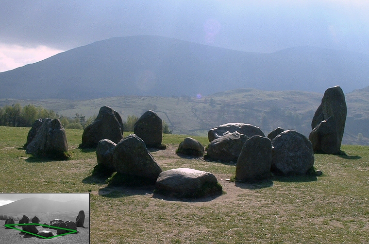
The circle consists thirty-eight metamorphic slate blocks, thirty-three standing and five fallen, thought to have been sourced from the ground surface locally as glacial erratics and although the circle builders may not have had to move the stones far, transporting them would still have required considerable organisational effort. Stone circle expert and author Aubrey Burl suggests the task would have involved a minimum of seventy workers to shift stones averaging around 4 tons but with the heaviest stone estimated to weight in the region of a massive 16 tons. This stone is marked on the plan below as Stone 26 based on the numbering system used by C. W. Dymond with the plan showing standing stones marked in black and fallen stones in grey. Stone 26 is also the tallest megalith at Castlerigg measuring around 2.3 metres in height and is one of only two stones, along with Stone 23, whose long axis is set radially to the circle.  The stones of Castlerigg do not actually form a true circle but can be described as a flattened oval with a long axis axis measuring 32.6 metres north to south and the shorter roughly east to west axis being
29.9 metres. Although the arc from the southeast round through the west and up to the north is almost circular, the stones of the eastern quadrant are shifted slightly inwards with the circumference of the stones as suggested by Alexander Thom marked with the red dashed line on the plan. This flattening of the ring also corresponds to a slight fall in the ground level at this point of the circle and it could be the positioning of the stones in this sector was a constructional device to maintain the illusion of circularity from within the interior of the circle. The stones of Castlerigg do not actually form a true circle but can be described as a flattened oval with a long axis axis measuring 32.6 metres north to south and the shorter roughly east to west axis being
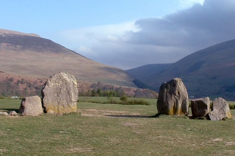
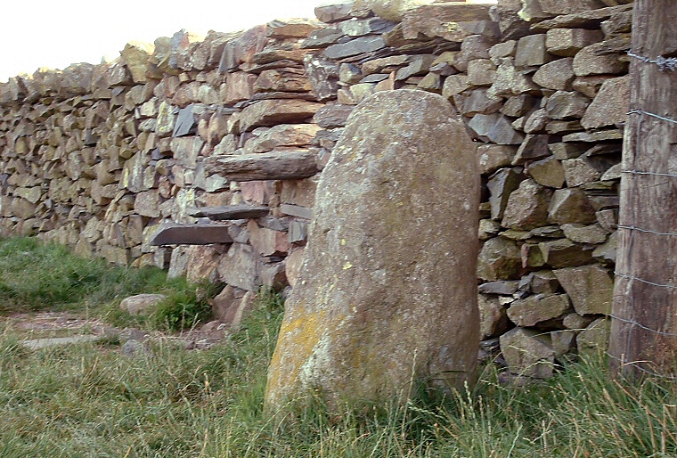
29.9 metres. Although the arc from the southeast round through the west and up to the north is almost circular, the stones of the eastern quadrant are shifted slightly inwards with the circumference of the stones as suggested by Alexander Thom marked with the red dashed line on the plan. This flattening of the ring also corresponds to a slight fall in the ground level at this point of the circle and it could be the positioning of the stones in this sector was a constructional device to maintain the illusion of circularity from within the interior of the circle. Located at the due north of the ring is what is assumed to be the original entrance, shown in the photograph above taken at sunset. Here a short run of stones are set almost edge to edge either side of a pair of tall and broad portal slabs, both measuring about 1.7 metres in height and set 3 metres apart. This almost symmetrical entrance frames an impressive view outwards from the circle, northwards down the valley of the Glenderaterra Beck with the slopes of Latrigg and Lonscale Fell to the left and Blease Fell to the right (see photograph below). A couple of the smaller flanking stones between Stones 2 and 3 may either be broken stumps or packing stones while Dymond adds the base of another stone that was already missing by his time as Stone 49 on the plan. Although Castlerigg is thought to be fairly intact with most of the stones in their original position (but see antiquarian record below) several gaps within the circle suggest a handful of stones may now be missing from the site and a total of about forty-two circle-stones may be a reasonable estimate for the original number. Adjoining the eastern interior of the circle is a rectangular setting of ten stones known as 'The Sanctuary' that measures around 7.5 metres by 3.5 metres (Stones 39 to 48). As its eastern edge is formed by three of the circle stones it is assumed to be either contemporary with the circle or added at some later date, however its purpose and age remain unknown. Over the years it has been suggested that it formed an inner 'sanctum' reserved for special ceremonies or that it may be the remains of a funerary structure, may have had some astronomical significance or be aligned with the hill of Great Mell Fell 7 miles (11km) away. The only documented excavation at Castlerigg took place within these stones around 1882 when a Mr. W. Kinsey Dover cut a trench along almost its entire length, however his report is disappointingly brief: 'Depth of dark superficial soil to where the yellow undisturbed soil appears, 14 inches, with the exception of a small portion at the west end where the black soil mixed with stones continued to a depth of 3 feet. Near the bottom here, I found what I think to be a few small pieces of burned wood or charcoal, also some dark unctuous sort of earth' (Dover in Anon. 1883 p505). The 'unctuous' or greasy soil he found at the bottom of the pit with the charcoal may suggest organic remains, perhaps prehistoric and from a cremation pyre or the ritually deposited remains of a feast but equally we can't discount the possibility that they are the result of action by Medieval farmers. It was this later use of the land surrounding the circle for agriculture that has left the tell-tale lines of ridge and furrow that are visible on aerial photographs in oblique sunlight and it is probable that what is sometime interpreted as a slight bank around the entrance stones is the result of soil movement related to agricultural activity at the site, the interior of the circle was apparently left unploughed.. In the mid 19th century Benjamin Williams claimed that the interior of the circle contained the remains of three cairns. While there are faint trances of a 3 metre diameter shallow ditch enclosing a low mound in the northeast quadrant (shown as the green ring above as noted by Dymond) and possibly another mirroring it on the opposite side of the entrance along with poorly defined low mound just within the entrance itself, it is not clear what these represent. The first two may indeed be traces of later intrusive burials but we can't rule out the possibility of unrecorded antiquarian excavations, or illicit treasure seeking by locals in the previous centuries.. About 90 metres to the southwest of the circle a single stone just under a metre tall stands by a wall and stile (image below right) and it has been proposed that it may have formed an outlier to the circle, perhaps marking a celestial event or routeway to the stones. If it did then its original position has been lost, as has only been in place since 1913 having previously been laid horizontally and used as a stepping stone over a fence. A series of scratch marks along one edge are believed to be due to it being repeatedly hit by a plough meaning it must have lay beneath the soil before being removed and dragged to the field boundary by a irate farmer when the land surrounding the circle was under cultivation. |
   The entrance, the 'Sanctuary' and the outlying stone. Click to see enlarged images as a slideshow. |
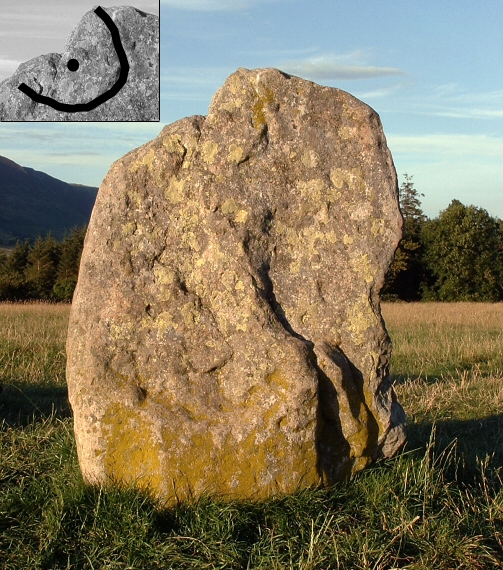
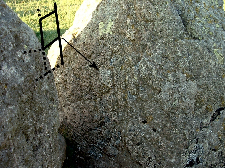
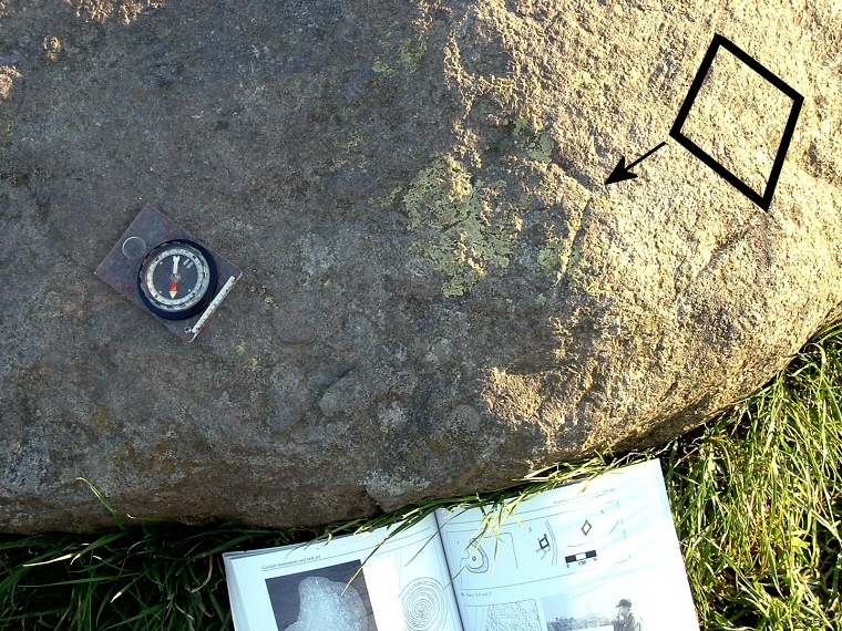
| Possible rock-art at Castlerigg? In recent years several possible prehistoric carvings on the stones at Castlerigg have come to light which have been documented by rock art researcher and author Stan Beckensall and three examples are shown in the photographs below with Beckensall's interpretation drawn in black. From left to right, there is what may are a partial cup and ring towards the top inner face of Stone 35, a faint lozenge or hatch motif on the inner face of Stone 30 very close to where it almost touches its neighbour Stone 39 and a clear lozenge or parallelogram on the northern face of the fallen Stone 13. Beckensall proposes a further ring or the beginning of a spiral motif on the inner face of Stone 39 which forms one of the stones of the 'Sanctuary' although he admits this may be a natural feature. However an examination and re-evaluation of these markings by Kate Sharpe (2007) casts doubt on both their authenticity and age. She suggests the 'cup and ring' may be a natural geological feature as may be the hatched pattern on Stone 30, this being the result of natural fissures in the rock. The lozenge is very finely incised which would probably indicate that it was cut with a metal tool and is probably of recent date and the possible ring or spiral could not be located by her during the survey. |
   Possible cup and ring, a lattice and a lozenge. Click to see enlarged images as a slideshow. |
| The most famous, or infamous, motif at Castlerigg was first noticed in 1995, and promptly disappeared again - a large clockwise spiral pattern on the inner face of Stone 29 facing into the 'Sanctuary'. Two photographs showing the faint spiral appear in Stan Beckensall's 'Prehistoric Rock Art in Cumbria' (2002) along with two clear wax-on-paper rubbings produced by Beckensall himself and although the photographs show an identical spiral, they don't quite match with Beckensall's rubbings. (Note 1) The finding of such a rare carving would be a major rock-art discovery but despite a laser scan of the stone by a team from Durham University lead by Margarita Diaz-Andreu and further laser profiling and photographic sensing surveys by Chris Brooke from Nottingham University, no trace of the spiral could be found, nor has it been seen since. The only conclusion that was reached was that the spiral may had been painted onto the stone in a substance such as yoghurt which may have slightly altered the colour of a thin layer of lichen on the face of the stone. Once this rubbed off, the spiral vanished with it. Castlerigg's role in the axe trade? The Neolithic saw an increased demand for land for cereal cultivation and stock pasture which in turn fueled a demand for axes to fell trees. Axes made from the fine-grained greenish-grey volcanic ash, from what is referred to by petrologists as the 'Borrowdale Volcanic Group' sourced from the area around Great Langdale and particularly the high peak of the Pike of Sticke seemed to have been highly prized, indeed axes from the Langdale Pikes alone account for around 40% of all such tools found in Britain. Why this should be is not clear as elsewhere in Britain equally suitable stone or flint would often been much easier to source and transport locally. However axes may have held a symbolism in the Neolithic that went way beyond their utilitarian use as mere tools, it could be that they were highly prized prestige objects that not only conferred status on their owners but were seen as having ritualistic value and may have been curated over long periods of time being exchanged between individuals or communities as a 'gift that binds' creating obligations upon those who received them. As such it could be that axes from the Langdale area were viewed further afield as exotic items precisely due to distance, effort and danger associated with obtaining the raw material for their manufacture. 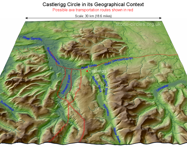 It has been suggested that prehistoric sites such as stone circle and henges were somehow involved with the distribution of these axes. Axe 'roughouts', blocks of stone roughly flaked to shape and size would have been obtained from the Langdale Peaks then transported to lowland sites for further refining in places where sandstone was available for grinding and polishing the axe into its finished form. As Castlerigg is located almost exactly 10 miles (16km) north of the Pike of Stickle and is accessible either along winding valley routes or more likely a direct trek over the fells it would seem plausible that the circle may have played a role as a secondary distribution centre, providing easy access for the movement of axes to the north and west along the River Derwent and towards the lowlands around the Solway or out to the east following the Rivers Greta and Glendermachin towards the Pennines and beyond along what is now the route of the A66 (The height-shaded elevation map left shows an area of roughly 350 square miles around Castlerigg, with possible axe routeways drawn in red, based on Taylor 2016, Fig. 10. Click to enlarge). It has been suggested that prehistoric sites such as stone circle and henges were somehow involved with the distribution of these axes. Axe 'roughouts', blocks of stone roughly flaked to shape and size would have been obtained from the Langdale Peaks then transported to lowland sites for further refining in places where sandstone was available for grinding and polishing the axe into its finished form. As Castlerigg is located almost exactly 10 miles (16km) north of the Pike of Stickle and is accessible either along winding valley routes or more likely a direct trek over the fells it would seem plausible that the circle may have played a role as a secondary distribution centre, providing easy access for the movement of axes to the north and west along the River Derwent and towards the lowlands around the Solway or out to the east following the Rivers Greta and Glendermachin towards the Pennines and beyond along what is now the route of the A66 (The height-shaded elevation map left shows an area of roughly 350 square miles around Castlerigg, with possible axe routeways drawn in red, based on Taylor 2016, Fig. 10. Click to enlarge). However as attractive as this theory is, there are issues with the scenario. Firstly, although there have been finds of unfinished and polished axes around the Keswick area, and even close to the circle itself (Note 2), there is no great concentration of finds and the only cache of axes recovered so far was at Portinscale 2.5 miles (4 km) west of Castlerigg (Note 3). Secondly, recent evidence suggests that the heyday of Langdale axe production may have been shorter than previously thought, perhaps only falling between 3800BC-3500BC, this poses a problem of chronology in relation to Castlerigg. Stone circles are notoriously difficult to date accurately, short of excavating beneath the stones in the hope of finding dateable environment evidence. Aubrey Burl believes Castlerigg may be one of the first circles to have been built in Britain and suggests a date of around 3200BC, which is in line with what English Heritage regard as the earliest date the monuments appeared in the country. If both sets of dates are roughly accurate (and admittedly that is a big if) then this leaves us with a gap of several hundred years after the Langdale axes had lost their cachet and before the stones of Castlerigg were erected. If this is the case then is probably more likely that it was the area around the head of Derwent Water and such places as Portinscale that had been focus of axe distribution. Unless a later source of raw material was being utilised and transported along similar routes that passed close to the circle then it could be that Castlerigg's relationship to the the axe trade was perhaps as a memorial to something that had been rather than was. The antiquarian record. One of the first account of Castlerigg comes from William Stukeley, the Lincolnshire born antiquarian more famous for his work in Wiltshire. While he often produced detailed sketches and provided invaluable descriptions of some of the sites he studied, his record of a visit to Castlerigg in the summer of 1725 is unusually scant. His great work 'Itinerarium Curiosum' was first published a few months prior to the visit but In the expanded 1776 version published after his death he tells us that - 'not far from the banks of the river Greata, I observed another Celtic work, very intire: it is 100 foot in diameter, and consists of forty stones, some very large. At the east end of it is a grave, made of such stones, in number about ten: this is placed at the very east point of the circle, and within it: there is not a stone wanting, though some are removed a little out of their first station: they call it the Carsles, and, corruptly I suppose, Castle-rig.'. The grave he talks about is of course the 'Sanctuary' within the circle. However, Stukeley then drops a bombshell, as a final and almost throwaway comment he adds 'There seemed to be another larger circle in the next pasture towards the town.' ... and tells us nothing more. No author since has mentioned the existence of a second circle which, if Stukeley was correct, would have been located to the west and slightly downslope of Castlerigg. Stukeley was an astute and critical observer but his later obsession with druids sullied his reputation amongst some later antiquarians and archaeologists. Over time though some of the sites he recorded that others later dismissed as fantasy have turned out to be very much real so we cannot dismiss his account out of hand. Interestingly Irene Evans draws parallels with the circles at Swinside and Long Meg which are both believed to have been associated with their own now destroyed second circles as pointing to a tradition of Cumbrian paired monuments which she believes may have been related to the symbolic and physical movement between different landscape zones. |
   Pennant's plan, Hutchinson and Pyne's drawings. Click to see enlarged images as a slideshow. |
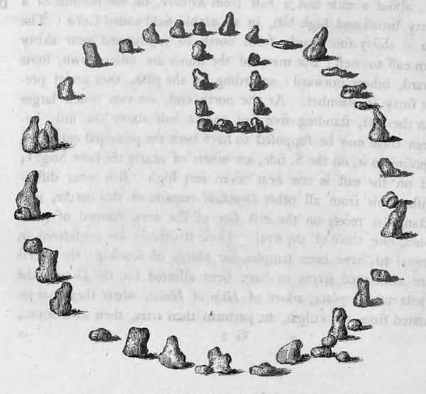
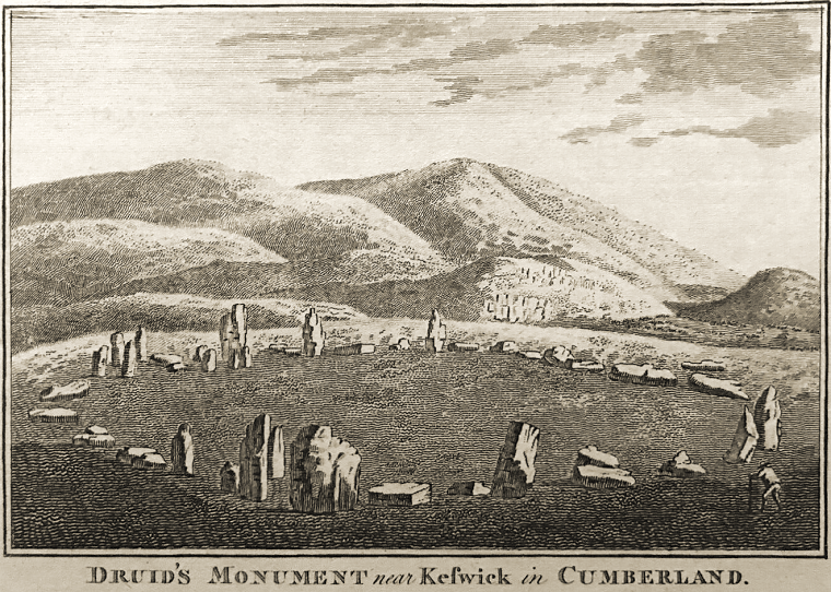
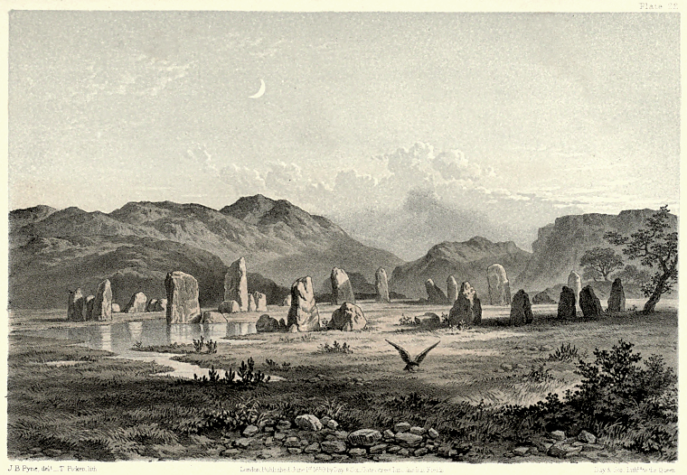
The first plan of Castlerigg appears to be by Thomas Pennant who visited the site on his way to Scotland in 1772 (above left, click to enlarge image). His drawing published in 1776 has north at the left side of the image with its large entrance stones recognisable, the 'Sanctuary' is shown and some of the other stones match the modern layout, however he shows thirty-nine or forty circle stones depending on how we interpret the picture and he also notes that 'many of the stones are fallen down, some inwards, others outwards'. In the lower right (the southwest) he shows a single stone just outside the circle next to two other small stones or possibly one stone on top of another (the upper stone casts no shadow), these presumably are the three fallen stones at the southwest of the modern circle. He also seems to show some of the stones to the upper right (the southeast) as fallen, all the remaining stones in this sector today are standing. It is always risky relying on antiquarian accounts and illustrations for accuracy and it is unlikely Pennant draw the plan in situ as the shadows cast by the stones imply the sun was shining from almost due north - a physical impossibility. At around the same time William Hutchinson provides us with a sketch of Castlerigg (middle image above), that accompanies his expanded second edition of 'An Excursion to the Lakes' published in 1776 and which was also reproduced in 'The London Magazine' of 1779 bringing the circle to a wider audience. He places the entrance in the foreground to the left of centre and it appears to show the circle in a rather ruinous state and with a fallen stone just beyond the circle to the southwest in approximately the same location as Pennant's stray stone. Another almost identical illustration by Hutchinson contained in his later 'History of the County of Cumberland' however omits this stone completely. Curiously in both images he appears to place a stone within the circle itself, just beyond the eastern entrance stone. Despite the usual caveats about these old drawings it does seem that some of the circle stones must have been moved and re-erected in the late 18th or early 19th century, although the work seems to have gone unreported. However we are lucky that the site still exists at all, as Hutchinson rather alarmingly states that during his visit to the stones in 1773: 'A clergyman whose property the pasture ground is, in which this monument stands ... told us he was determined to destroy the place, as it prejudiced his ground; so that perhaps by these sacrilegious hands, the curious will shortly be deprived of this valuable piece of antiquity'. (4) Thankfully he never carried out his threat to remove the stones and Castlerigg became a staple of the tourist itinerary of the Lakes and most later accounts of the circle are aimed squarely at this audience, often simply repeating earlier texts and offering up romanticised views of the stones such as Pyne's 1859 depiction of the site shown above right. It was not until 1877 that Charles William Dymond conducted what was an exemplarary survey for its time of Castlerigg and produced a detailed numbered plan that shows that the stones were pretty much as they appear today, the plan near the top of this page is based largely on his work. He also provided us with individual stone dimensions (Table 1) and as well as giving his own observations he compiled all the relevant previous literature about the site he could find. However by this time Castlerigg's popularity and ease of accessibility had brought new pressures to the site. In a letter to the president of the Society of Antiquaries of London a group of local antiquaries expressed the view that the circle was in dire need of legal protection, deploring the fact that: 'During the Lake season huge chars-a-bancs daily discharge large numbers of tourists and trippers at the circle, who proceed to cut their initials on the stones' (Ferguson 1889, p272). The practice was clearly so bad that notices had to be erected to try to put a stop to it, unfortunately it still occasionally takes place so perhaps it was one of these Victorian or later vandals who cut the lozenge into Stone 13. Although the circle had already been scheduled for protection under the newly created Ancient Monuments Act a few years previously the site was still owned privately (by a Miss Edmondson, of Lancashire) and eventually it was saved for the nation by being taking into the care of the Ancient Monuments Board in the 1920's and today the stones are safely under the guardianship of the National Trust. Notes: (1) Both photographs along with Beckensall's wax rubbing are also shown in Kate Sharpe's PhD Thesis of 2007 on page 102. Link in bibliography. (2) There seems to be some confusion about whether or not stone axes have been recovered from within the circle itself. Aubrey Burl (1995) says 'In 1875 an unpolished stone axe was found inside the ring itself', as have several authors since. However earlier records state an axe with a 'roughly chipped surface' was 'found near he so-called Druid's Circle, Keswick'. (Ward 1876, p100). Also in more detail 'An unpolished stone axe 8 1/2 ins, by 2 1/2 ins, tapering to 1 1/4 ins. of local stone found near Castlerigg Circle by Mr.Lowthian in 1875'. (Spence 1935, p176). More recently in an inventory of axes found around Keswick an unpolished axe is recorded as 'Nr Castlerigg stone circle' (Clare 2003, Table 1 p213). These presumably all refer to the same axe. There is also an earlier report in relation to the circle that states that 'a rude stone club and a stone celt' were 'found there' (Williams 1856, p225) but sadly doesn't elaborate on the exact context or location of these two finds. The 'rude stone club' may have been an unfinished axe roughout while the word 'celt' is an antiquarian term for a prehistoric axe. (3) A brief contemporary account of the finding of the hoard of axes at Portinscale states: 'During the excavation of a pond for Mr. T. Harris at Mossgarth, Portinscale, in November, 1901, four stone celts were found ... All are unpolished, but of the well-known Lake district type of large greenstone celts of Neolithic age ... The celts were lying on the boulder clay under about 18in. of peat and mixed soil, together with cobbles and chippings of similar stone, as if the implement-maker had been at work there ... Boughs and trunks of oak were lying in the peat, and one log ... was found in an upright position, with the top rudely chipped as if by some clumsy instrument'. (Anon. 1902 p418). Another partly polished axe found a few months later is mentioned in the same report but it is not clear if it came from the same hoard. (4) Hutchinson was clearly not impressed with nearby Keswick which he described as 'a mean village, without any apparent trade... the houses are homely and dirty... there is a town house in the market place of the most uncouth architecture... very indifferent accommodations here for travellers', however he is even less taken by his landlord 'Nothing is more disagreeable to people...than to meet with a drunken soporiferous Innkeeper whose small share of natural intelligence is totally absorbed, and who has nothing remaining of human, but his distorted image, and his impertinence'. (Excursion to the Lakes, 1774, p107). Most modern visitors have a much different impression of the area, in my original notes for Castlerigg I wrote: 'Because of its position in the heart of the Lake District, right on the edge of Keswick, the circle attracts many visitors whatever the weather or season. If you want a chance to have the site to yourself, an early morning or late evening visit is recommended.' |
(Table 1) Castlerigg stone dimensions, all measurements in cm.  Dymond's original stone measurements from his survey of Castlerigg were in feet and inches, this table shows them converted to centimetres and with added notes. Fallen stones were not given a height or thickness. The stone numbers match those in the plan at the top of the page, circle stones being numbered from 1-38 while the 'Sanctuary' stones are from 39-48 and shaded orange. From Dymond 1881, Plate: 'A Stone Circle near Keswick, Cumberland'. |
 The 'classic' view of Castlerigg stone circle looking southeast with from left to right, the hills of Clough Head, Great Dodd, Watson's Dodd, Stybarrow Dodd, Raise and Helvellyn on the horizon and with Low Rigg and High Rigg the lower range immediately beyond the circle and finally Great How which stands at the head of Thirlmere and the edge of the Castlerigg Fells being the darker hills to the right of the picture. The entrance to the circle is marked by the tall stone on the left. |
 View of the circle looking towards the west - Spring 2003. One of the entrance stones is the tallest of the group of stones to the right, the 'Sanctuary' is immediately beyond the stones in the middle of the picture and the tallest of the Castlerigg stones is the odd shaped stone standing above the level of the horizon towards the left. |
 View to the east. On the left is the distant hill of Great Mell Fell while Clough Head is centre-right (2002) |
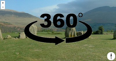 360 Degree Panorama |
Site Visits / Photographs: June 1990, August 1994, May 2002, April 2003, August 2003. References: Anderson, W. 1914. Some recent Observations at the Keswick Stone Circle. TCWAAS, Series 2, Vol 15, 99-112. Anderson, W. 1923. Plough Markings on Stones. TCWAAS, Series 2, Vol 23, 109-111. Anon. 1883. Excursions and Proceedings. TCWAAS, Series 1, Vol 6, 490-511. Anon. 1902. Finds at Portiscale. TCWAAS, Series 2, Vol 2, 418-419. Barnatt, J. 1987. The Design and Distribution of Stone Circles in Britain... Thesis, (PhD). University of Sheffield. Barrowclough, D. 2010. Prehistoric Cumbria. Stroud: The History Press. Beckensall, S. 1999. British Prehistoric Rock Art. Stroud: Tempus Publishing Ltd. Beckensall, S. 2002. Prehistoric Rock Art in Cumbria. Stroud: Tempus Publishing Ltd. Britton, J. and Brayley, E. 1802. Cumberland - The Beauties of England and Wales Vol III. London. Brooke, C. 2004. Castlerigg Stone Circle Cumbria. A ground-based remote sensing survey. ADS. Burl, A. 1976. The Stone Circles of the British Isles. London: Yale University Press. Burl, A. 1979. Rings of Stone. London: Frances Lincoln Publishers Ltd. Burl, A. 1994. The stone circle of Long Meg and Her Daughters. TCWAAS, Series 2, Vol 94, 1-11. Burl, A. 1995. A Guide to the Stone Circles of Britain, Ireland and Brittany. London: Yale University Press. Clare, T. 2003. A case of one or two stone axes? TCWAAS, Series 3, Vol 3, 213-214. Clare, T. 2007. Prehistoric Monuments of the Lake District. Stroud: Tempus Publishing Ltd. Cope, J. 1998. The Modern Antiquarian. A Pre-Millennial Odyssey through Megalithic Britain. London: Thorsons. Cummins, W. 1979. Neolithic stone axes... In: Clough, T. & Cummins, W. eds. Stone Axe Studies. CBA 23, 5-12. Dymond, C. 1881. A Group of Cumberland Megaliths. TCWAAS, Series 1, Vol 5, 39-57. Diaz-Andreu, M., Brooke, C., Rainsbury, M. and Rosser, N. 2006. The spiral that vanished. JAS, 33, 1580-87. Dugdale, J. 1819. The new British Traveller. London. Evans, I. 2005. Prehistoric Landscapes of Cumbria. Thesis, (PhD). University of Sheffield. Farrah, R. 2008. A guide to the Stone Circles of Cumbria. Kirkby Stephen: Hayloft Publishing Ltd. Fell, C. 1950. The Great Langdale stone-axe factory. TCWAAS, Series 2, Vol 50, 1-14. Ferguson, R. 1889. Report on Ancient Monuments.... TCWAAS, Series 1, Vol 10, 271-274. Grose, F. 1785. The Antiquities of England and Wales. Vol I New Edition. London: Hooper. Hutchinson, W. 1774. An Excursion to the Lakes...August 1773. London: Wilkie & Goldsmith. Hutchinson, W 1794. The History of the County of Cumberland. London: Jollie. Hutchinson, W (?). 1779. Druid's Monument nr Keswick in Cumberland. London Magazine, March, Plate op. 104. Last, J. 2011. Introductions to Heritage Assets: Prehistoric Henges and Circles. English Heritage. Nicolson, J. and Burn, R. 1777. History and Antiquities of Westmorland and Cumberland. London. Pennant, T. 1776. A Tour in Scotland and Voyage to the Hebrides 1772. Second Edition. London: White. Piggott, S. 1950. William Stukeley: An Eighteenth-Century Antiquary. Oxford: Clarendon Press. Pyne, J.B. 1859. Lake Scenery of England. London: Day & Son. Sharpe, K. 2007 Motifs, monuments and mountains: prehistoric rock art ... Thesis, (PhD). Durham. Sharpe, K. 2015. Connecting the dots. Cupules and communication ... Lake District. Expression. 9. 109-116. Spence, J. 1935. Report of the Committee for Prehistoric Studies. TCWAAS, Series 2, Vol.35, 170-181. Stukeley, W. 1776. Itinerarium Curiosum. Centuria II. London: Baker & Leigh. Taylor, S. 2016. Journeys to Neolithic Langdale. Lithics: the Journal of the Lithic Studies Society, Vol 37, 15-32. Thom, A. 1967. Megalithic Sites in Britain. London: Oxford University Press. Ward, J. 1876. The Geology of the Northern part of the Lake District. London: HMSO. Williams, B. 1856. On some ancient monuments in the county of Cumberland... PSAL, Vol 3, 224-227. CBA = Council for British Archaeology. JAS = Journal of Archaeological Science. PSAL = Proceedings of the Society of Antiquaries of London. TCWAAS = Transactions of the Cumberland and Westmorland Antiquarian and Archaeological Society. Historic England Research Records Hob Uid: 9828. National Monuments Record Number: NY 22 SE 1. County Number: CU 114. |