
The empty field beyond the grass is all that remains of Little Argham henge
This must once
have been an important part of the Gypsey Race landscape but plough damage
means there is now nothing to be seen at ground level at Little Argham Henge,
or as it is sometimes more interestingly known - Maiden's Grave.
Excavations in 1964 uncovered an oval bank with an internal ditch and two opposing entrances making it what is known as a Class 2 henge. These entrances, one to the northwest and the other to the southeast would have led into to a leveled central area that was found to contain a mysterious line of four post holes, although as yet I can find no evidence of any other finds from the site. Looking at an aerial survey of cropmarks it would seem that the dimensions of the henge were as follows - the internal area was 30 metres across, the outer edge of the ditches covered an area of 65 metres in diameter with the external bank giving the whole monument a total diameter of about 95 metres.
Looking at the satellite image below the remains of the henge earthwork can be seen as a faint crop mark, although it appears more circular than oval, and the northwest entrance can be clearly seen as a gap through the bank in the zoomed image to the bottom right. Just to the left is the crop mark of what could have been a previous course of the Gypsey Race putting the henge right by the banks of a kink in the stream, this would have close parallels to the henge at Shearman's Wath in Lincolnshire. Curiously there is a large semicircular crop mark to the east of the henge - I have no idea what this could be or how old it is.
The henge stands just under 200 metres from the course of the Argham Cursus and it could be that both monuments were in use at the same time although the henge may be slightly later and represent a shift in the ceremonial use of the landscape of the Great Wold Valley after the cursus had fallen out of use.
Date: late Neolithic or early Bronze Age
See also: Introduction and maps of the Rudston Landscape
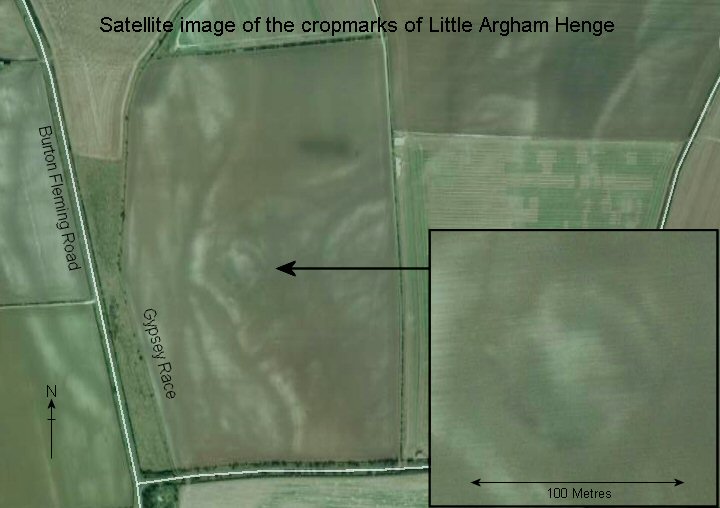
Satellite image of the area of Little Argham Henge, the henge appears as a faint circular mark arrowed on the picture and shown enlarged lower right. The crop marks to the left (west) of the henge could indicate a previous course of the Gypsey Race stream.