
Looking southwards down the length of the cursus from the minor road leading to Little Argham.
At nearly two
and a half miles in length, Cursus D or the Argham Cursus is the longest
of the four Neolithic
cursus
monuments that have so far been recognised from the aerial survey of cropmarks
in the fields surrounding the village of Rudston.
Although it curves slightly during its course it always seems to stay aligned on Rudston Beacon, a low hill to the south of the village which is the site of several later round barrows and which also marks the southern end of Cursus A (the Beacon Cursus). It seems this hill may have been significant to the early settlers of the land around Rudston and some of the possible reasons are explored on the Rudston Beacon page.
Cursus D starts on the southern slopes of a hill between Maiden's Grave and Argham but soon descends into the Great Wold Valley and passes within 200 metres of the vanished Argham Henge and although henges are thought to be slightly later in date than cursuses it is possible that the two monuments here were in use at the same time. The photograph above shows the view south along the cursus from a minor road just to the south of Argham Henge with the approximate lines of the cursus marked with dashed lines (these have been calculated from archaeological maps marked with cropmarks discovered by aerial photography) and at this point the cursus is about 100 metres wide, Rudston Beacon can be seen on the horizon. A short distance further south the cursus crosses the Gypsey Race twice as the stream takes a turn to the southeast, continues south and then turns southwest before continuing along its original course. Unfortunately I do not know if the stream has been diverted at this point to provide irrigation for fields or whether this kink is the original course of the waters - it is certainly shown as existing on the first edition Ordnance Survey maps of the area from the early 19th century.
The two pictures below are taken from this kink, the first shows the view northwards and the eastern ditch of the cursus would have passed just within the line of bushes on the right hand side which line the banks of the Gypsey Race as it runs south. In the next picture, taken a few metres away on the other side of the road this time looking south, the stream has changed direction and is traveling southwest through the gully at the bottom of the view while the cursus climbs the side of a slight rise in the ground. After this point it continues for another kilometre across relatively flat land until it crosses the path of the Cursus C (the Glebe Farm Cursus) and then fades beneath the modern village of Rudston, the top photograph on the Cursus C page shows its route as it enters the village while the map at the bottom of the Rudston Introduction and maps page shows the relationship between the four cursus monuments clustered around the village.

Looking north from the minor road to Littlethorpe and High Caythorpe. The unploughed track through the line of young crops is curiously almost exactly down the middle of the cursus. On the right hand side the edge of the cursus runs along the bank of the Gypsey Race which is marked by the line of low bushes and at this point the stream makes a dramatic turn to the southwest where the cursus crosses it for the second time.

This picture was taken just a few feet from the previous one but on the opposite side of the road looking south after the stream has changed direction and is flowing southwest. The elevation map shows a slight rise in the ground at this point but it is much more visible as a low hill when viewed first hand and the cursus cuts across both the stream and the hill before a level run into Rudston.

Bing satellite image overlaid with the course of the Argham Cursus showing its close proximity to the Gypsey Race, Little Argham Henge and the Rudston Monolith. The inset image shows the relationship between Cursus D highlighted in red and the other three cursuses in the Rudston landscape.
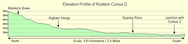
This elevation profile shows that unlike the Beacon and Glebe Farm cursuses which start and finish on high ground but dip into the Great Wold Valley near the centre of their courses, the Argham Cursus follows a steady two and a half mile downhill route, starting on a hillside above Argham Henge and ending beneath the village of Rudston.