
Major Hayman Rooke recorded and illustrated six stones at the circle sometime before 1780 (see image at the bottom of page) while Thomas Bateman instead noted seven stones in his 1848 book 'Vestiges of the Antiquities of Derbyshire'. He described the situation of the stones as being 'originally placed in an upright position, which they still in a great measure retain', however elsewhere in the same book he describes the circle as consisting of 'six stones standing'. Bateman considered that a slightly raised area within the stones could have been the plough-damaged remains or a tumulus or grave mound and conducted an excavation of the mound from which he recovered some poorly fired pottery sherds and a number of flints, some of which appeared to have been burned.
In 1870 the local antiquarian Llewellynn Jewitt noted the name of the stones as 'The Nine Ladies' (not to be confused with the famous Nine Ladies of Stanton Moor) although he stated that only four stones were remaining by that time and like Bateman, he also believed them to have been set around a central grave mound. Jewitt seems to have conducted a rather haphazard investigation of the site in 1877 assisted by William Greenwell, an antiquarian more well known for his work on the Yorkshire Wolds, however they failed to make any finds but may have disturbed or displaced some of the stones.
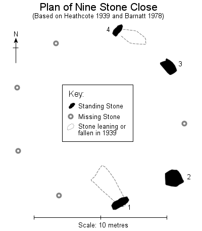 What remains today is an arc of four stones ranging in height from 1.95 metres to 2.2 metres. Extending the arc into a full ring would suggest that the the stones were originally laid out in a circle of about 13-14 metres in diameter, the stones being freestanding rather than being set into a rubble bank like many of the circles of smaller stones on the eastern moors of the Peak District. The inverted triangular stone shown in the foreground to left of the photographs above and below fell in 1936 and was re-erected in 1939 by Percy Heathcote who measured its total length to be 3.6 metres of which he estimated 1.3 metres would have been below ground before its fall (on the plan left marked as stone 1 under Heathcote's numbering system, Barnatt numbers them the opposite way round). During the work a further heavily leaning stone (stone 4 left) was straightened, Heathcote pointed out that the bowl shaped solution hollows caused by the collection of rainwater on one face rather than the top of the stone suggested that it had probably been in a leaning state 'since prehistoric times'.
 It seems that at least one more of the stones has survived as one of similar proportions to those of the circle, although perhaps a little shorter, now stands as part of a drystone wall about 70 metres to the south (second photograph below). Again Bateman can furnish us with more information as he noted the presence of two standing stones 'of similar dimensions' which stood about 80 yards (70 metres) to the south - it is assumed the stones were taken from the circle for use as gateposts with one now missing. These two, together with the six still standing in 1847 plus a further stone also now missing would give us the full tally of nine stones implied in the site's name.
About 370 metres south of the circle across the open fields is the strange rock outcrop of Robin Hood's Stride (on the left of the second photograph below). It is suggested that it may have served as a sacred hill alter and may indeed be the reason for the construction of the stone circle on this particular spot as from the centre of the circle the midsummer full moon at its maximum elevation is seen to pass behind and between two natural stone pillars on top of the hill. Interestingly a cup and ring marked rock was discovered as recently as 2001 between, but not quite in line with, Robin Hood's Stride and Nine Stone Close perhaps hinting at the significance of the relationship between the circle and the outcrop.
There are several legends and myths attached to the circle, one claims that the stones dance at midday, another says they dance at midnight, while locals in the 19th century claimed that strange lights were sometimes seen in nearby wood. Another story recorded in the 19th century tells of a farm labourer who found a clay pipe at the stones, and when he smoked it, was able to see through the surface of the earth near one of the stones to a land inhabited by fairy folk.
Date: Late Neolithic or early Bronze Age
Note: In Heathcote's drawing of the circle from 1939 he has rotated the plan or his compass arrow through about 180 degrees. The orientation of the above plan is correct.
 Night-time view of Nine Stone Close looking north and lit by flash.
 Stone in a fieldwall to the south of Nine Stone Close which may have come from the circle.
 To the left the rock outcrop of Robin Hood's Stride is silhouetted against the winter sky.
 Rooke's drawing of Nine Stone Close from the 18th century. The four largest stones would seem to be a good match for the remaining stones at the site so presumably it was the two smaller stones that have since been lost.
 Site Visits / Photographs:
Autumn 2000, February 2010.
References:
Barnatt, J. 1978. Stone Circles of the Peak. London: Turnstone Books.
Barnatt, J. 1987. The Design and Distribution of Stone Circles in Britain... Thesis, (PhD). University of Sheffield.
Bateman, T. 1848. Vestiges of the Antiquities of Derbyshire. London: John Russell Smith.
Burl, A. 1976. The Stone Circles of the British Isles. London: Yale University Press.
Burl, A. 1995. A Guide to the Stone Circles of Britain, Ireland and Brittany. London: Yale University Press.
Cope, J. 1998. The Modern Antiquarian. A Pre-Millennial Odyssey through Megalithic Britain. London: Thorsons.
Goss, W. 1889. The Life and Death of Llewellynn Jewitt. London: Henry Gray.
Guilbert, G., Garton, D. and Walters, D. 2006. Prehistoric Cup-and-Ring Art... D.A.J., Vol 126, 12-30.
Heathcote, J. P. 1934. Birchover, Its Prehistoric and Druidical Remains. Second Edition. Chesterfield: Edmunds.
Heathcote, J. P. 1939. The Nine Stones, Harthill Moor. Derbyshire Archaeological Journal, Vol 60, 126-128.
Jewitt, L. 1870. Grave-mounds and their Contents: A Manual of Archaeology. London: Groombridge.
Morgan, V. and Morgan, P. 2001. Rock around the Peak. Wilmslow: Sigma Leisure.
Rooke, H. 1782. An account of some Druidical Remains on Stanton and Hartle Moor. Archaeologia, 6, 110-115.
Historic England Research Records Hob Uid: 311354,
National Monuments Record Number: SK 26 SW 3.
County Number: DR 94.