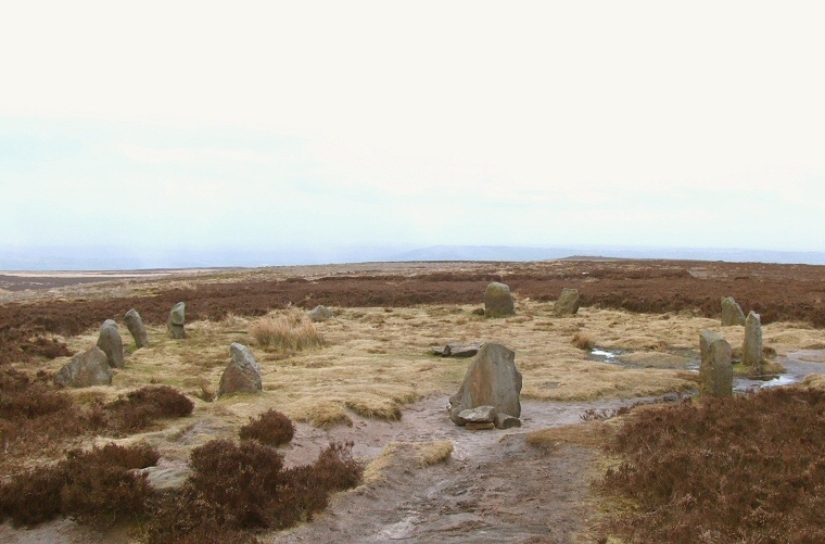
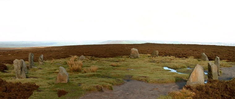
The Twelve Apostles looking east in late winter.
Set high on moorland at a height of 380
metres above sea level the Twelve Apostles stone circle stands close to
the Dales Way track 20-30 minutes walk from the popular
tourist attraction of the Cow and Calf rocks and
car-park. Although the circle is often referred to as
'The Twelve Apostles of Ilkley Moor' the site is in fact
on Burley Moor, one of the constituent areas of the
larger Rombalds Moor.
This is a delightful circle set in a location that on a clear day provides extensive views although the site as it is today has been reconstructed with some of the stones showing evidence of breakage and at least one of having been cemented back together. The twelve stones that the name implies were recorded as still standing in the late 19th century but by the time of archaeologist Arthur Raistrick's survey of the site in the late 1920's most of the stones were noted as being in a fallen state.
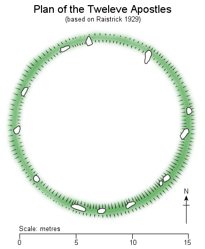 Raistrick's
survey (on which the plan
left is based) led him to suggest large gaps
between some of the existing stones may indicate that
other stones might have once stood within the
circumference of the ring, if he is correct then
estimates of between sixteen and twenty stones in total would
seem reasonable. However we should be careful
in placing too much store in the plan as Raistrick
himself shows thirteen stones and their positions don't
quite tally with the layout of the circle today.
The stones themselves are comprised of the local gritstone and none are particularly large, measuring between about half a metre and a metre in height with the tallest measuring about 1.2 metres high. They are laid out in what is close to a true circle of a diameter of between 15 and 16 metres.
The stones were set into an earth and rubble bank which although recorded as standing to a height of about 60cm and 1.2 metres wide by Raistrick has now all but been worn away, most probably by the impact of visitor numbers as the circle's proximity to the track makes it a popular stopping-off point as well as a popular destination in its own right. Old accounts describe the stones as being having been partially buried under a thick layer of heather much like the nearby but lesser known Grubstones circle still is today. It is probable that the erosion of the bank has been a contributory factor in the stones falling as a result of them losing their shallow foundation footing.
Opinion is divided on what type of monument the Twelve Apostle may have originally represented. It may have been an small embanked stone circle, indeed the layout and aspect of the circle is similar to some of the numerous embanked stones circles found further south in Derbyshire. However the damage to the bank means there is now no obvious entrance to the movement and no pair of the remaining stones stand out as indicating that they might have flanked such an entrance. Instead of being a stone circle the site may have been some variant of a ring cairn with the bank and inset stones forming an outer ring delimiting some form of funerary space, either represented by a now vanished cairn or a flat or hollowed central area in which cremated remains were buried.
There have been suggestions that the stones were used for observation of the movement of the moon or celestial bodies - indeed it was once known as a 'Druidical Dial Circle', however the fact that the stones have fallen and been re-erected on several occasions since at least the early 20th century means that any claims to alignments incorporating individual stones would now be very difficult to prove. Yorkshire prehistory expert Paul Bennett states that from the circle the rising summer solstice sun appears exactly above the White Horse hill-figure at Kilburn in North Yorkshire around 33 miles (53 km) away but as the horse is a modern addition to the landscape we can't put this down as anything other than an interesting coincidence. However he also proposes that the Twelve Apostles form a precise isosceles triangle with the two nearby sites of the Grubstones Circle and the possible but disputed Backstone Circle. That might be easier to prove but whether the alignment was an intentional plan on the part of the builders or a result of chance is open to debate.
One thing that can't be disputed however is the superb location of the circle. It is nestled on an eastern slope below the high point of the moor which means that although the views to the west are blocked by rising land there are panoramic views in all other directions far across West and North Yorkshire. In the viewshed analysis below areas shaded salmon pink represent those parts of the surrounding landscape that would theoretically be visible to an observer standing at the circle (given perfect viewing conditions of course, something that can't be guaranteed on Rombalds Moor). The views sweep round in a horseshoe from Embsay Moor in the northwest through Denton, Askwith and Weston Moors, along the valleys of the River Wharfe and River Aire to the east, across part of Baildon Moor to the south and right round to Thornton Moor in the southwest. Interestingly very little of Rombalds Moor is visible from the circle, neither is the circle near to any of the concentrations of rock carvings that the area is famous for which mainly lie on lower slopes around the periphery of the moor, particularly to the north. This may suggest that the circle dates from a different period of utilisation of the moor to the rock-art but it may also be that the circle was constructed in a sanctified area, set apart from and away from the day to day lives of the inhabitants of Rombalds Moor and only to be visited at prescribed times of the year for whatever ritual purpose might have been conducted at the site.
Probable date: Bronze Age
See also Ilkley Moor & Rombalds Moor Introduction
This is a delightful circle set in a location that on a clear day provides extensive views although the site as it is today has been reconstructed with some of the stones showing evidence of breakage and at least one of having been cemented back together. The twelve stones that the name implies were recorded as still standing in the late 19th century but by the time of archaeologist Arthur Raistrick's survey of the site in the late 1920's most of the stones were noted as being in a fallen state.
 Raistrick's
survey (on which the plan
left is based) led him to suggest large gaps
between some of the existing stones may indicate that
other stones might have once stood within the
circumference of the ring, if he is correct then
estimates of between sixteen and twenty stones in total would
seem reasonable. However we should be careful
in placing too much store in the plan as Raistrick
himself shows thirteen stones and their positions don't
quite tally with the layout of the circle today.
Raistrick's
survey (on which the plan
left is based) led him to suggest large gaps
between some of the existing stones may indicate that
other stones might have once stood within the
circumference of the ring, if he is correct then
estimates of between sixteen and twenty stones in total would
seem reasonable. However we should be careful
in placing too much store in the plan as Raistrick
himself shows thirteen stones and their positions don't
quite tally with the layout of the circle today.The stones themselves are comprised of the local gritstone and none are particularly large, measuring between about half a metre and a metre in height with the tallest measuring about 1.2 metres high. They are laid out in what is close to a true circle of a diameter of between 15 and 16 metres.
The stones were set into an earth and rubble bank which although recorded as standing to a height of about 60cm and 1.2 metres wide by Raistrick has now all but been worn away, most probably by the impact of visitor numbers as the circle's proximity to the track makes it a popular stopping-off point as well as a popular destination in its own right. Old accounts describe the stones as being having been partially buried under a thick layer of heather much like the nearby but lesser known Grubstones circle still is today. It is probable that the erosion of the bank has been a contributory factor in the stones falling as a result of them losing their shallow foundation footing.
Opinion is divided on what type of monument the Twelve Apostle may have originally represented. It may have been an small embanked stone circle, indeed the layout and aspect of the circle is similar to some of the numerous embanked stones circles found further south in Derbyshire. However the damage to the bank means there is now no obvious entrance to the movement and no pair of the remaining stones stand out as indicating that they might have flanked such an entrance. Instead of being a stone circle the site may have been some variant of a ring cairn with the bank and inset stones forming an outer ring delimiting some form of funerary space, either represented by a now vanished cairn or a flat or hollowed central area in which cremated remains were buried.
There have been suggestions that the stones were used for observation of the movement of the moon or celestial bodies - indeed it was once known as a 'Druidical Dial Circle', however the fact that the stones have fallen and been re-erected on several occasions since at least the early 20th century means that any claims to alignments incorporating individual stones would now be very difficult to prove. Yorkshire prehistory expert Paul Bennett states that from the circle the rising summer solstice sun appears exactly above the White Horse hill-figure at Kilburn in North Yorkshire around 33 miles (53 km) away but as the horse is a modern addition to the landscape we can't put this down as anything other than an interesting coincidence. However he also proposes that the Twelve Apostles form a precise isosceles triangle with the two nearby sites of the Grubstones Circle and the possible but disputed Backstone Circle. That might be easier to prove but whether the alignment was an intentional plan on the part of the builders or a result of chance is open to debate.
One thing that can't be disputed however is the superb location of the circle. It is nestled on an eastern slope below the high point of the moor which means that although the views to the west are blocked by rising land there are panoramic views in all other directions far across West and North Yorkshire. In the viewshed analysis below areas shaded salmon pink represent those parts of the surrounding landscape that would theoretically be visible to an observer standing at the circle (given perfect viewing conditions of course, something that can't be guaranteed on Rombalds Moor). The views sweep round in a horseshoe from Embsay Moor in the northwest through Denton, Askwith and Weston Moors, along the valleys of the River Wharfe and River Aire to the east, across part of Baildon Moor to the south and right round to Thornton Moor in the southwest. Interestingly very little of Rombalds Moor is visible from the circle, neither is the circle near to any of the concentrations of rock carvings that the area is famous for which mainly lie on lower slopes around the periphery of the moor, particularly to the north. This may suggest that the circle dates from a different period of utilisation of the moor to the rock-art but it may also be that the circle was constructed in a sanctified area, set apart from and away from the day to day lives of the inhabitants of Rombalds Moor and only to be visited at prescribed times of the year for whatever ritual purpose might have been conducted at the site.
Probable date: Bronze Age
See also Ilkley Moor & Rombalds Moor Introduction
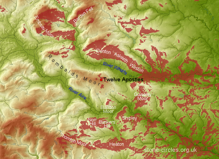
Twelve Apostles viewshed analysis. The
image above covers an area of about 29 miles x 21
miles or 609 square miles (46km x 24km or 1564
square km) around the Twelve Apostles stone circle.
The areas shaded salmon pink indicate parts of the
surrounding landscape that are theoretically visible
to an observer standing at the circle.
An evening view of the Twelve Apostles.
Site Visits / Photographs:
Late 1990's, April 2002, February 2004, March 2009
References:
Barnatt, J. 1987. The Design and Distribution of Stone Circles in Britain... Thesis, (PhD). University of Sheffield.
Bennett, P. 1995. Circles, Standing Stones & Legendary Rocks of W. Yorkshire. Loughborough: Heart of Albion Press.
Burl, A. 1976. The Stone Circles of the British Isles. London: Yale University Press.
Burl, A. 1995. A Guide to the Stone Circles of Britain, Ireland and Brittany. London: Yale University Press.
Burnham, A. (Ed.). 2018. The Old Stones...Megalithic Sites of Britain and Ireland. London: Watkins.
Deacon, V. 2018. The Rock-art Landscapes of Rombalds Moor... Thesis, (PhD). University of York.
Colls, J. 1846. Letter upon some early remains discovered in Yorkshire. Archaeologia. Vol 31, 299-307.
Collyer, R. and Horsfall Turner, J. 1885. Ilkley: Ancient & Modern. Otley: Walker & Sons.
Cope, J. 1998. The Modern Antiquarian. A Pre-Millennial Odyssey through Megalithic Britain. London: Thorsons.
Moorhouse, S. 1977. The Yorkshire Archaeological Register 1976. YAJ, Vol 49, 1-2.
Raistrick, A. 1929. The Bronze Age in West Yorkshire. Yorkshire Archaeological Journal. Vol. 29, 354-365.
Historic England Research Records Hob Uid: 49847
Scheduled Monument: 25313.
NMR Number: SE 14 NW 3.
County Number: 37.
