 The Bush Barrow excavated by Sir Richard Colt Hoare and William Cunnington. |
The Normanton Down group
is a large collection of barrows 1km south of Stonehenge
that is thought to be one of the most important Neolithic
and Bronze
Age barrow cemeteries in the country. It consists of three long
barrows, a mortuary enclosure and nearly forty round
barrows, these being a mix of twenty five bowl barrows, five bell
barrows (one a double barrow), seven disc barrows and single saucer
barrow. The first monuments on the site would have been the mortuary enclosure to the southwest of the group and the three Neolithic long barrows. The one to the southwest next to the modern track (Wilsford 30) is oriented east-west, another just south of the A303 road (Amesbury 14) is oriented south-southeast to north-northwest while the third small barrow standing towards the centre of the group has an orientation of northeast-southwest. These long barrows would have predated the first phases of construction at Stonehenge. Later during the late Neolithic and through the Early Bronze Age and contemporary with the main earth and stone monument building phases at Stonehenge many round barrows started to be built along the slight ridge of land on Normanton Down that overlooks Stonehenge and gives the cemetery its linear nature. The most famous of these is a bowl barrow to the west of the group that measures 15 metres in diameter and nearly 2.5 metres high known as the 'Bush Barrow' which contained the remains of an adult male buried around 1900BC. Excavated in 1808 by Sir Richard Colt Hoare and William Cunnington, the skeleton was accompanied by some of the richest prehistoric finds ever recovered in Britain. Their report states - ' On reaching the floor of the barrow, we discovered the skeleton of a stout and tall man lying from south to north:  the
extreme length of his thigh bone was 20 inches. About 18 inches south
of the head we found several brass (i.e. bronze) rivets intermixed with
wood and some thin bits of brass nearly decomposed. These articles covered
a space of 12 inches or more; it is probable therefore that they were
the mouldered remains of a shield. Near the right arm was a large dagger
of brass and a spearhead of the same material, full 13 inches long,
and the largest we have ever found. the
extreme length of his thigh bone was 20 inches. About 18 inches south
of the head we found several brass (i.e. bronze) rivets intermixed with
wood and some thin bits of brass nearly decomposed. These articles covered
a space of 12 inches or more; it is probable therefore that they were
the mouldered remains of a shield. Near the right arm was a large dagger
of brass and a spearhead of the same material, full 13 inches long,
and the largest we have ever found.Immediately over the breast of the skeleton was a large plate of gold, in the form of a lozenge and measuring 7 inches by 6 inches. The even surface of this noble ornament is relieved by indented lines, checks and zigzags, forming the shape of the outline, and forming lozenge within lozenge, diminishing gradually towards the centre. We next discovered, on the right side of the skeleton, a very curious perforated stone, some wrought articles of bone, many small rings of the same material and another lozenge of gold. As this stone bears no marks of wear or attrition, I can hardly consider it to have been used as a domestic implement, and from the circumstances of it being composed of a mass of seaworms or little serpents, I think we may not be too fanciful in considering it an article of consequence.' The two gold lozenges they recovered are shown above along with a squarish gold item interpreted as a belt fastening. The 'article of consequence' was a mace head carved from sea fossils which can be seen in this photograph from Wiltshire Heritage Museum. Many of the other barrows in this group also contained grave goods including amber beads, amber pendants, gold beads, cups, bronze daggers, bronze pins, a perforated swan bone that could have been a flute, lignite rings and shale beads. |
 Looking east across the Normanton Down barrow group. |
 Large bell barrow at the northwest of the group (north of Normanton Gorse) |
 Plan of the barrows in the Normanton Down Group. |
 Satellite view of the Normanton Down Group with an inset showing the above plan overlaid on the photograph. |
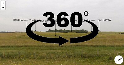
360 Degree Annotated Panorama