
Elevated view of Barbrook I stone circle looking northeast from in front of the largest stone.
This is a typically small Derbyshire embanked stone circle with an associated nearby funerary cairn in an area that also contains two other circles - Barbrook
II and Barbrook III, as well as the ring-cairns of Barbrook IV and Barbrook V. They form part of what could well be described as a fossilised Bronze
Age landscape containing visible traces of settlement sites, clearance cairns and prehistoric field systems.
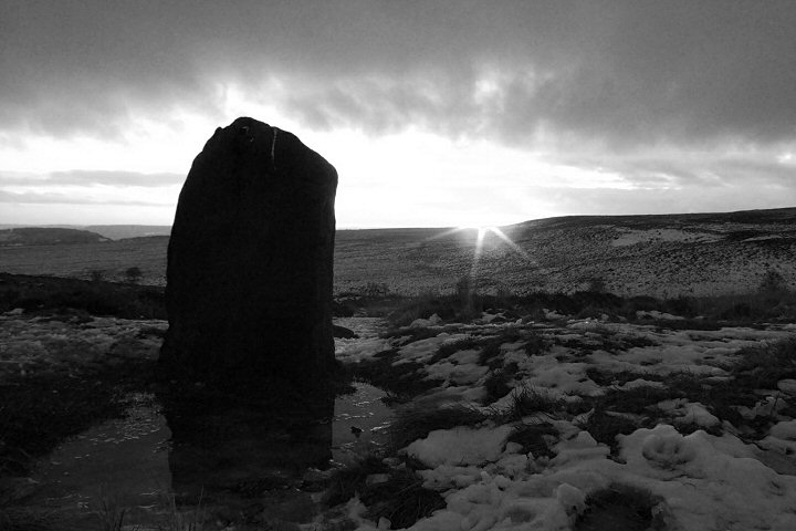
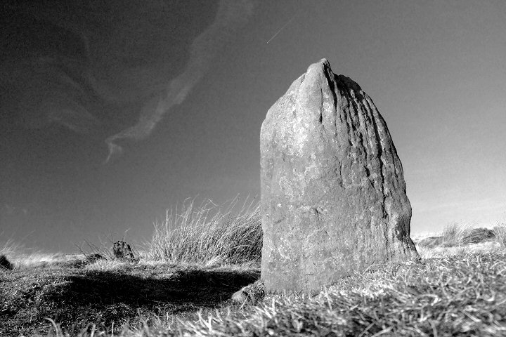
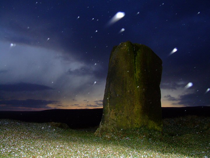
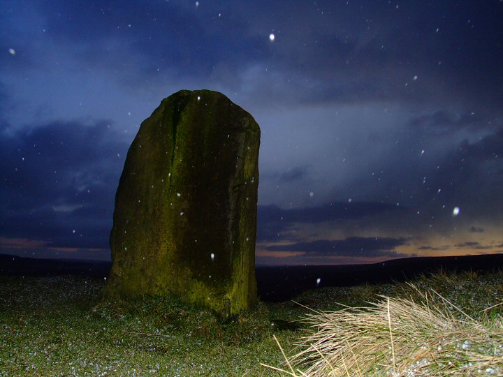
Barbrook I is the southernmost of the three circles and contains twelve remaining gritstone blocks arranged in a ring measuring about 14.5 metres northwest to southeast and 12.5 metres northeast to southwest with a distinct flattening across its south-western arc (see plan below left). The stones average about half a metre in height with the exception of a prominent stone to the southwest (Stone 10 using Barnatt's numbering system) that stands just a shade over a metre tall, the modern track that leads to the circle from the main path across the moor leads directly to this stone. A gap in the ring along the northeast arc opposite Stone 10 may have formed an entrance into the circle but is more likely to have been the location of a now missing thirteenth stone.
The stones are set into the inner edge of a continuous earth and rubble bank of between 2 metres to 2.5 metres width that has now become so badly eroded that it is barely noticeable, standing only about 30 cm in height. Traces of small stone blocks and dry-stone walling suggest the inner edge of the bank had a revetment wall similar to the nearby Barbrook II while the interior of the circle contains no original features although it appears to have been leveled during the construction of the site. Traces of a couple of trenches within the interior are the result of a two haphazard excavations carried out at the behest of the Duke of Rutland in the early 20th century by his gamekeeper Mr E. H. Peat, who discovered only three un-diagnostic worked flints for his labours.
Barbrook I stands on gently southwest sloping land on the west side of Ramsley Moor as it leads down to the stream of Bar Brook - from where the three circles and two ring cairns take their names. It is quite a secluded location with the near horizon blocking the view to the northwest, round through the north and right down to the southeast. Big Moor and the settlement sites around Swine
Sty, with Baslow Edge and White Edge beyond, dominate the middle distance on the opposite side of the stream to the west and the views out from the circle only open up to the south towards Gardom's Edge, itself the location of several prehistoric settlement and ceremonial monuments and to the south-southwest where the Derwent Valley finally allows a narrow window that offers distant vistas stretching over ten miles towards the Derbyshire Dales. Incredibly on a clear day the small copse of beech trees that now crowns the top of Minninglow Hill with its Neolithic and Bronze Age chambered cairn can be seen twelve miles (19 km) away on the horizon. It is interesting to speculate that while the inhabitants of Ramsley and Big Moor may have regarded those at Gardom's Edge as their near neighbours (assuming the settlements were contemporary), would they have viewed the tomb at Minninglow as also being in their neighbourhood or as something foreign on the far edge of their world?
with the near horizon blocking the view to the northwest, round through the north and right down to the southeast. Big Moor and the settlement sites around Swine
Sty, with Baslow Edge and White Edge beyond, dominate the middle distance on the opposite side of the stream to the west and the views out from the circle only open up to the south towards Gardom's Edge, itself the location of several prehistoric settlement and ceremonial monuments and to the south-southwest where the Derwent Valley finally allows a narrow window that offers distant vistas stretching over ten miles towards the Derbyshire Dales. Incredibly on a clear day the small copse of beech trees that now crowns the top of Minninglow Hill with its Neolithic and Bronze Age chambered cairn can be seen twelve miles (19 km) away on the horizon. It is interesting to speculate that while the inhabitants of Ramsley and Big Moor may have regarded those at Gardom's Edge as their near neighbours (assuming the settlements were contemporary), would they have viewed the tomb at Minninglow as also being in their neighbourhood or as something foreign on the far edge of their world?
Archaeologist and author John Barnatt (1978) proposes a handful of decent solar alignments visible from the circle, the principal one being at Midwinter when the rising sun first appears over the local horizon of the hillside directly above Stone 7 and disappears from sight, or 'sets' behind the higher ground of Baslow Edge above the tallest stone, Stone 10, with the sun's path almost matching the slope along the northern edge of the stone when seen from within the circle. At the Equinoxes the sun appears to rise behind Stone 5 and sinks behind White Edge above Stone 11 (the four rises and settings marked on the panorama at the bottom of the page). Barnatt's suggestion of a May Day sunset behind Stone 12 seems plausible, a Midsummer sunset close to a low cairn, perhaps less so. He further proposes a whole slew of complex alignments involving nine outlying standing stones, the nearby cairn and distant landscape features suggesting that 'the sun and moon could be observed accurately at any time of the year, with every sunset marked, the solstice and equinox sunrises and every lunar solstice position'. That's quite a claim and one I've never had the time or opportunity to investigate.
Environmental evidence from pollen samples recovered during the excavation of the nearby Barbrook II has revealed that the ceremonial monuments of the moor probably date from the centuries around 2000BC. By this period at the end of the Neolithic and moving into the early Bronze Age a warming of the climate in Britain meant that marginal upland landscapes such as the gritstone moors to the east of the Derwent could be brought into cultivation. This movement into the uplands seems to coincide with a change in the style of the ceremonial monuments the inhabitants chose to build and perhaps indicated a wider change in society, with a shift away from the large region centres such as Arbor Low with its massive henge and impressive internal circle of stones to the smaller embanked circles and ring cairns of the East Moors. These were very much local monuments constructed to serve the needs of individual communities, although the regional centres no doubt continued to see gatherings on important occasions. This use of newly useable land for stock pasture and cereal cultivation was however short-lived as the thin soils covering the porous gritstone quickly became exhausted and eventually waterlogged and developed into the familiar moorland we see today.
The Cairn
While there have been few finds from the circle itself, the cairn clearly visible on slightly higher ground about 50 metres away to the northeast (image below in its restored state) proved more productive when it was excavated in the mid 1960's. It was found to be revetted by a 7 metre diameter and 50 cm high stone kerb with an extended platform area or 'annexe' added to its eastern side measuring about 3 metres by 1.8 metres. This contained a Bronze Age urn standing upright on a small piece of stone with another inverted urn placed on top of it, inside were the cremated remains of a child and pieces of charcoal, presumably from the funeral pyre but possibly symbolic remnants from the family hearth. The main body of the cairn also contained a small quantity of cremated remains although some may have been lost during previous diggings, as well as urn sherds, a flint scraper and a stone with an oval dished hollow that may have been the result of being used for axe sharpening.
The cairn was also found to contain four stones featuring simple rock-art. One had a cup and ring motif, one had four cups along its edge, another had two or three cups and the final stone had a single cup mark - the stones have since been removed to Sheffield Museum.
Additional Notes:
1. Thomas Bateman recorded a circle near the Bar Brook stream of a similar dimension but containing thirteen stones in 1848, this is almost certainly Barbrook I but whether he miscounted the number of stones or whether a thirteenth stone was present at that time but has since been removed is not clear.
2. A damaged stone circle with a double ring of stones stands 1.9 miles (3 km) away to the west-northwest on Froggatt Edge.
3. Viewshed analysis of Barbrook I Stone Circle.

The theoretical field of view from Barbrook I with a horizontal coverage of 28.36km (17.6 miles) and vertical coverage of 23.13km (14.4 miles). The areas marked green are areas of land that are theoretically visible to an observer standing at the circle (given perfect viewing conditions). The small yellow dots represent other prehistoric sites (mostly of Bronze Age date) taken from both the National Monument Record as well as others included on this website. These include concentrations of monuments on the nearby Gardom's Edge as well as further afield on Harland Edge, Calton Pastures and Stanton Moor. Both Arbor Low and Minninglow are about at the limit of what can be seen from the circle.
Barbrook I is the southernmost of the three circles and contains twelve remaining gritstone blocks arranged in a ring measuring about 14.5 metres northwest to southeast and 12.5 metres northeast to southwest with a
distinct flattening across its south-western arc (see plan below left). The stones average about half a metre in height with the exception of a prominent stone to the southwest (Stone 10 using Barnatt's numbering system) that stands just a shade over a metre tall, the modern track that leads to the circle from the main path across the moor leads directly to this stone. A gap in the ring along the northeast arc opposite Stone 10 may have formed an entrance into the circle but is more likely to have been the location of a now missing thirteenth stone. The stones are set into the inner edge of a continuous earth and rubble bank of between 2 metres to 2.5 metres width that has now become so badly eroded that it is barely noticeable, standing only about 30 cm in height. Traces of small stone blocks and dry-stone walling suggest the inner edge of the bank had a revetment wall similar to the nearby Barbrook II while the interior of the circle contains no original features although it appears to have been leveled during the construction of the site. Traces of a couple of trenches within the interior are the result of a two haphazard excavations carried out at the behest of the Duke of Rutland in the early 20th century by his gamekeeper Mr E. H. Peat, who discovered only three un-diagnostic worked flints for his labours.
Barbrook I stands on gently southwest sloping land on the west side of Ramsley Moor as it leads down to the stream of Bar Brook - from where the three circles and two ring cairns take their names. It is quite a secluded location
with the near horizon blocking the view to the northwest, round through the north and right down to the southeast. Big Moor and the settlement sites around Swine
Sty, with Baslow Edge and White Edge beyond, dominate the middle distance on the opposite side of the stream to the west and the views out from the circle only open up to the south towards Gardom's Edge, itself the location of several prehistoric settlement and ceremonial monuments and to the south-southwest where the Derwent Valley finally allows a narrow window that offers distant vistas stretching over ten miles towards the Derbyshire Dales. Incredibly on a clear day the small copse of beech trees that now crowns the top of Minninglow Hill with its Neolithic and Bronze Age chambered cairn can be seen twelve miles (19 km) away on the horizon. It is interesting to speculate that while the inhabitants of Ramsley and Big Moor may have regarded those at Gardom's Edge as their near neighbours (assuming the settlements were contemporary), would they have viewed the tomb at Minninglow as also being in their neighbourhood or as something foreign on the far edge of their world? Archaeologist and author John Barnatt (1978) proposes a handful of decent solar alignments visible from the circle, the principal one being at Midwinter when the rising sun first appears over the local horizon of the hillside directly above Stone 7 and disappears from sight, or 'sets' behind the higher ground of Baslow Edge above the tallest stone, Stone 10, with the sun's path almost matching the slope along the northern edge of the stone when seen from within the circle. At the Equinoxes the sun appears to rise behind Stone 5 and sinks behind White Edge above Stone 11 (the four rises and settings marked on the panorama at the bottom of the page). Barnatt's suggestion of a May Day sunset behind Stone 12 seems plausible, a Midsummer sunset close to a low cairn, perhaps less so. He further proposes a whole slew of complex alignments involving nine outlying standing stones, the nearby cairn and distant landscape features suggesting that 'the sun and moon could be observed accurately at any time of the year, with every sunset marked, the solstice and equinox sunrises and every lunar solstice position'. That's quite a claim and one I've never had the time or opportunity to investigate.
Environmental evidence from pollen samples recovered during the excavation of the nearby Barbrook II has revealed that the ceremonial monuments of the moor probably date from the centuries around 2000BC. By this period at the end of the Neolithic and moving into the early Bronze Age a warming of the climate in Britain meant that marginal upland landscapes such as the gritstone moors to the east of the Derwent could be brought into cultivation. This movement into the uplands seems to coincide with a change in the style of the ceremonial monuments the inhabitants chose to build and perhaps indicated a wider change in society, with a shift away from the large region centres such as Arbor Low with its massive henge and impressive internal circle of stones to the smaller embanked circles and ring cairns of the East Moors. These were very much local monuments constructed to serve the needs of individual communities, although the regional centres no doubt continued to see gatherings on important occasions. This use of newly useable land for stock pasture and cereal cultivation was however short-lived as the thin soils covering the porous gritstone quickly became exhausted and eventually waterlogged and developed into the familiar moorland we see today.
The Cairn
While there have been few finds from the circle itself, the cairn clearly visible on slightly higher ground about 50 metres away to the northeast (image below in its restored state) proved more productive when it was excavated in the mid 1960's. It was found to be revetted by a 7 metre diameter and 50 cm high stone kerb with an extended platform area or 'annexe' added to its eastern side measuring about 3 metres by 1.8 metres. This contained a Bronze Age urn standing upright on a small piece of stone with another inverted urn placed on top of it, inside were the cremated remains of a child and pieces of charcoal, presumably from the funeral pyre but possibly symbolic remnants from the family hearth. The main body of the cairn also contained a small quantity of cremated remains although some may have been lost during previous diggings, as well as urn sherds, a flint scraper and a stone with an oval dished hollow that may have been the result of being used for axe sharpening.
The cairn was also found to contain four stones featuring simple rock-art. One had a cup and ring motif, one had four cups along its edge, another had two or three cups and the final stone had a single cup mark - the stones have since been removed to Sheffield Museum.
Additional Notes:
1. Thomas Bateman recorded a circle near the Bar Brook stream of a similar dimension but containing thirteen stones in 1848, this is almost certainly Barbrook I but whether he miscounted the number of stones or whether a thirteenth stone was present at that time but has since been removed is not clear.
2. A damaged stone circle with a double ring of stones stands 1.9 miles (3 km) away to the west-northwest on Froggatt Edge.
3. Viewshed analysis of Barbrook I Stone Circle.
The theoretical field of view from Barbrook I with a horizontal coverage of 28.36km (17.6 miles) and vertical coverage of 23.13km (14.4 miles). The areas marked green are areas of land that are theoretically visible to an observer standing at the circle (given perfect viewing conditions). The small yellow dots represent other prehistoric sites (mostly of Bronze Age date) taken from both the National Monument Record as well as others included on this website. These include concentrations of monuments on the nearby Gardom's Edge as well as further afield on Harland Edge, Calton Pastures and Stanton Moor. Both Arbor Low and Minninglow are about at the limit of what can be seen from the circle.

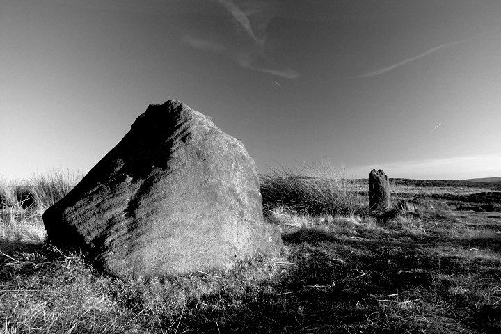
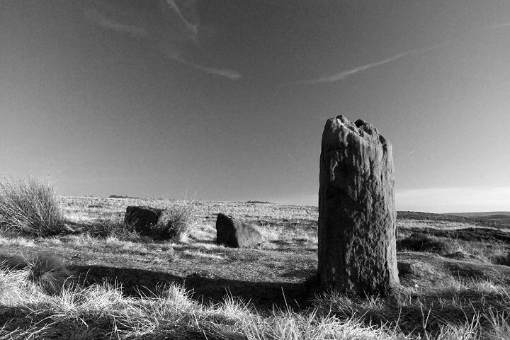
Barbrook I, the southern arc of stones from Stone 6 in the upper left to Stone 11 in the foreground.

The tallest stone (Stone 10) which is located to the southwest of the circle. The view is looking southwards with Harland Edge and Gibbet Moor on the horizon to the left, Gardom's Edge in the middle mostly obscured by the stone and the limestone uplands of the Dales District on the horizon to the right.

View looking over Barbrook I from slightly higher ground to the east with Big Moor appearing as the darker green and brown vegetation on the opposite side of the Bar Brook and White Edge appearing as the darker band on the horizon. The arc of the circle and the positions of the stones arc marked in white on the inset image. The photograph shows just how well the stones blend in with the the moorland vegetation.

The restored cairn to the northeast of the circle - looking southwest towards Gardom's Edge.
 Click
on the thumbnails above to enlarge the images as a slideshow.
Click
on the thumbnails above to enlarge the images as a slideshow.
360 Degree Panorama
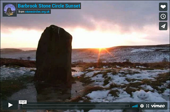
Midwinter Sunset Timelapse
Site Visits / Photographs:
Winter 1999, August 2007, September 2007, February 2008, December 2009, January 2010, February 2010 (two visits), March 2010, August 2010, December 2010.
References:
Ainsworth, S. 2001. Prehistoric Settlement Remains on the Derbshire Gritstone Moors. D.A.J., Vol 121, 19-69.
Barnatt, J. 1978. Stone Circles of the Peak. London: Turnstone Books.
Barnatt, J. 1987. The Design and Distribution of Stone Circles in Britain. Thesis, (PhD). University of Sheffield.
Barnatt, J. 1986. Bronze Age Remains on the East Moors of the Peak District. D.A.J., Vol 106, 18-100.
Barnatt, J. 1995. Neolithic and Bronze Age Radiocarbon Dates from the Peak District. D.A.J., Vol 115, 5-19.
Barnatt, J. 1999. Taming the land: Peak District Farming and Ritual in the Bronze Age. DAJ, Vol 119, 19-78.
Barnatt, J. 2000. ...Later Prehistoric Farming Communities...in the Peak. D.A.J., Vol 120, 1-86.
Barnatt, J. and Chambers, F. 1996. Recent research at Peak District Stone Circles. D.A.J., Vol 116, 27-48.
Barnatt, J. and Collis, J. 1996. Barrows in the Peak District. Recent Research. Sheffield: Collis Publications.
Barnatt, J. and Reeder, P. 1982. Prehistoric Rock Art in the Peak District. D.A.J., Vol 102, 33-44.
Bateman, T. 1848. Vestiges of the Antiquities of Derbyshire. London: John Russell Smith.
Burl, A. 1976. The Stone Circles of the British Isles. London: Yale University Press.
Burl, A. 1979. Rings of Stone. London: Frances Lincoln Publishers Ltd.
Burl, A. 1995. A Guide to the Stone Circles of Britain, Ireland and Brittany. London: Yale University Press.
Cope, J. 1998. The Modern Antiquarian. A Pre-Millennial Odyssey through Megalithic Britain. London: Thorsons.
Darvill, T. 2010. Prehistoric Britain. 2nd Edition. Abingdon: Routledge.
Dyer, J. (Editor). 1993. Discovering Prehistoric England. Princes Risborough: Shire Publications Ltd.
Edmunds, M. and Seaborne, T. 2001. Prehistory in the Peak. Stroud: Tempus.
Morgan, V. and Morgan, P. 2001. Rock around the Peak. Wilmslow: Sigma Leisure.
Thom, A. 1967. Megalithic Sites in Britain. London: Oxford University Press.
Historic England Research Records Hob Uid: 311677 (Circle), 311692 (Cairn).
Scheduled Monument: 1004599.
National Monuments Record Number: SK 27 NE 13 (Circle), SK 27 NE 18 (Cairn).
HER Number: 8001.
County Number DR 136.