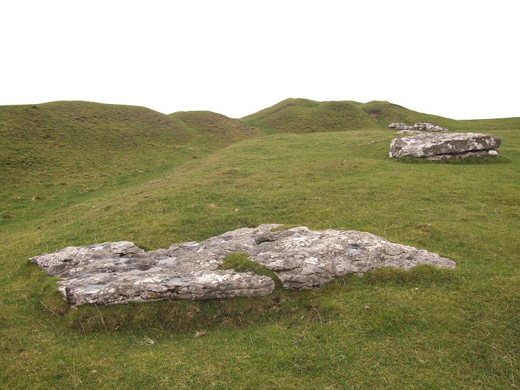
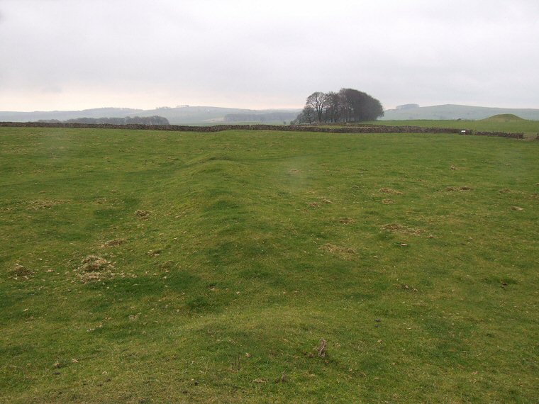
Arbor Low henge and circle, wide angle view looking northeast. |
|
|
High up in
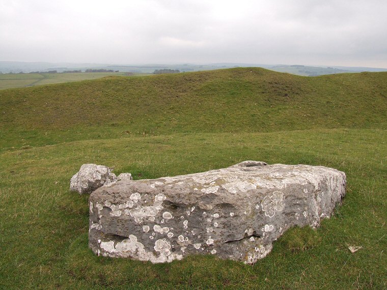
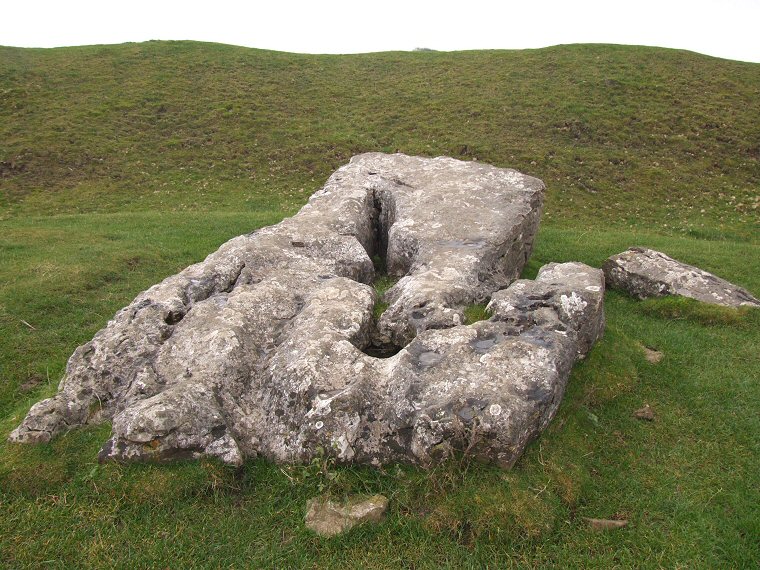
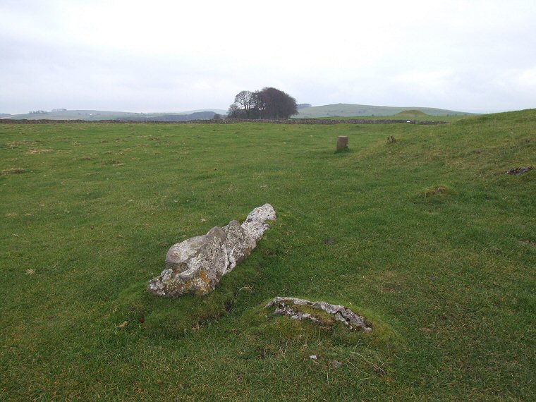
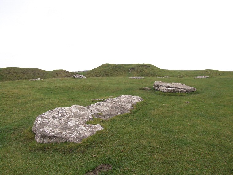
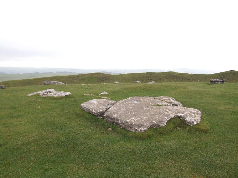
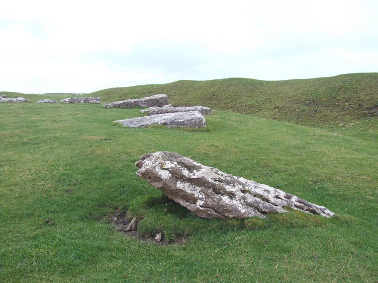
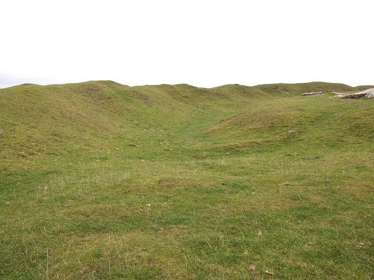
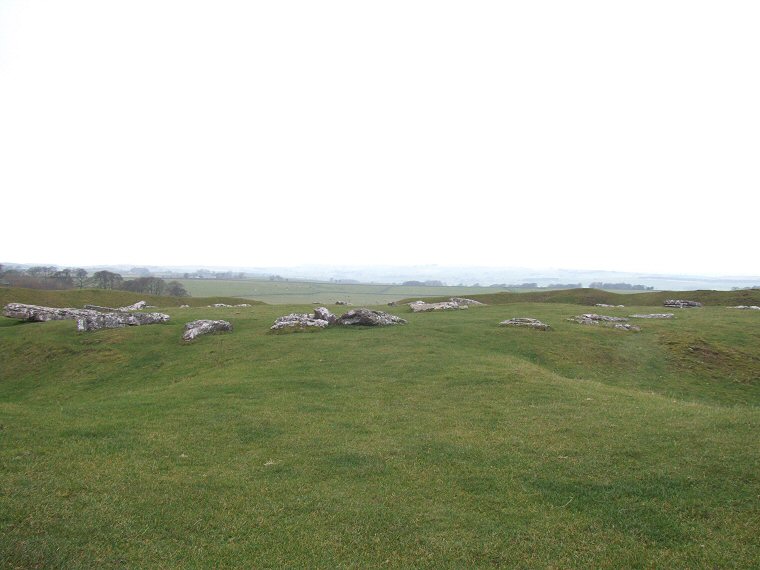
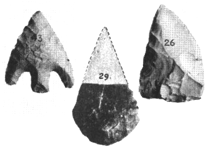
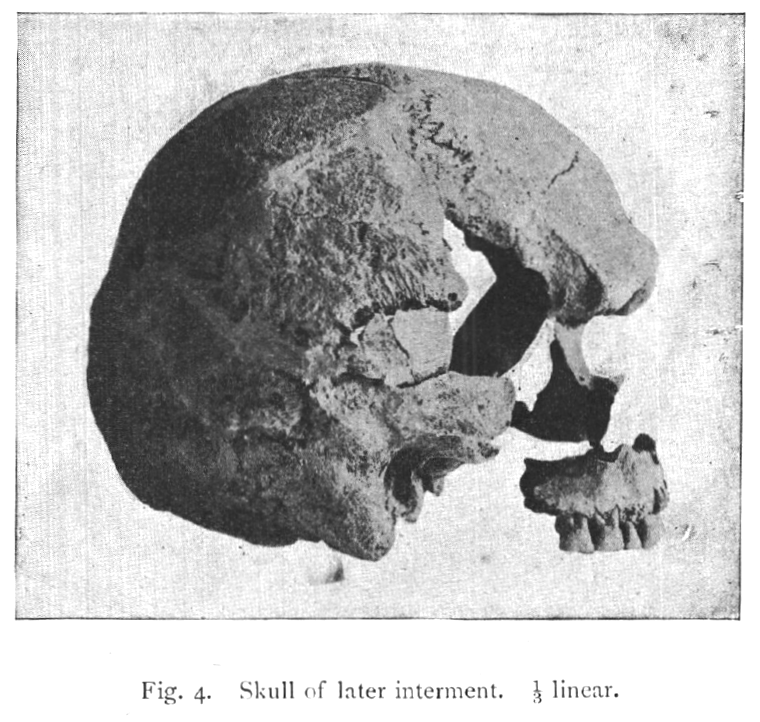
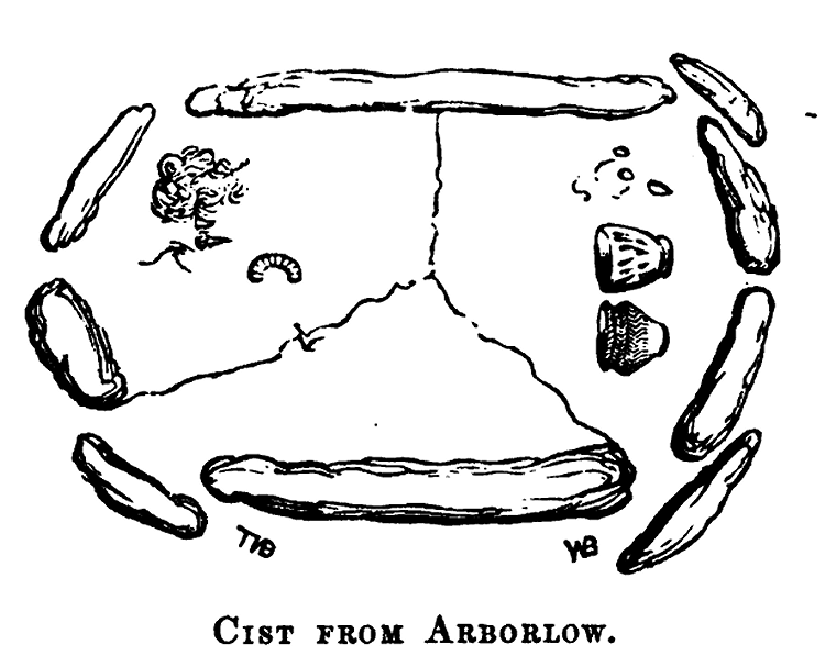
the Derbyshire Peak District on a northwards facing slope of Middleton Common is the henge earthworks and circle of prostrate weather-corroded stones of Arbor Low, a site regarded by stone circle authority Aubrey Burl as one of the wonders of megalithic Britain. Although sometimes referred to as 'the Stonehenge of the
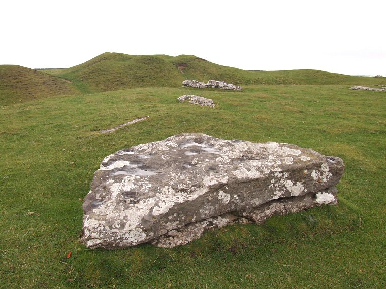
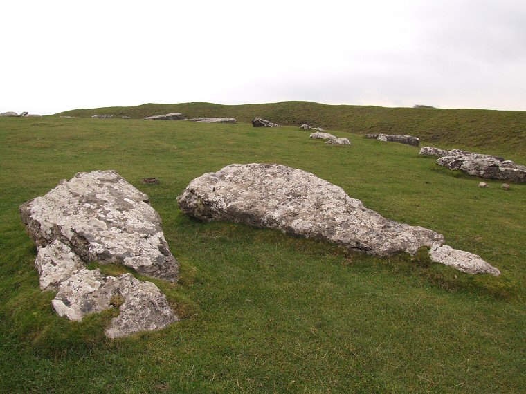
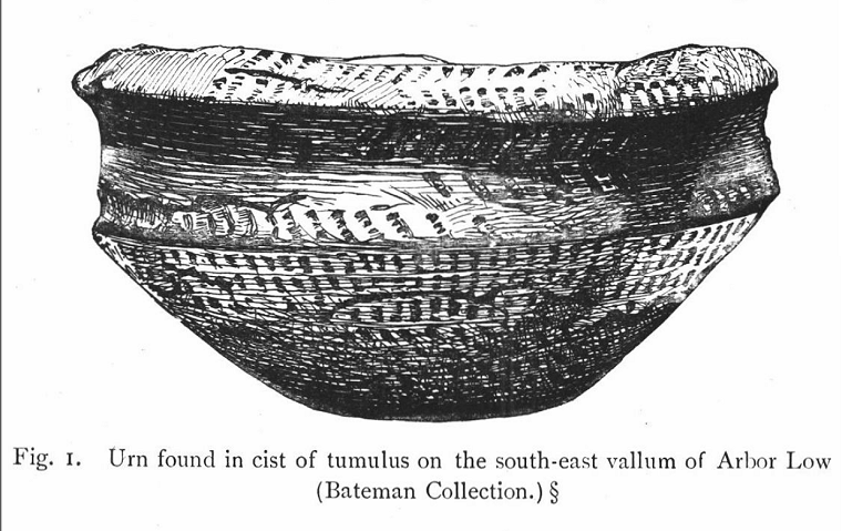
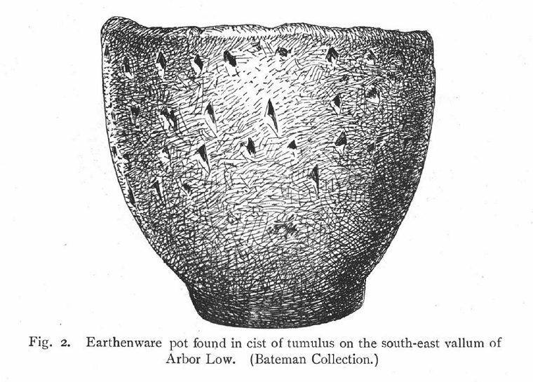
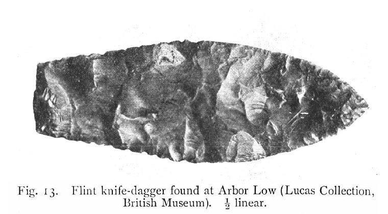
North' visitors to the last remaining limestone circle in Derbyshire may be disappointed that there are no massive upright stones and no trilithons here but neither are there queues of traffic, hoards of people and no visitor centre, in fact apart from the nearby farm and car park there are few modern intrusions. The open aspect of the site coupled with its extensive views, particularly to the north and with its minimum of modern clutter gives the impression of a monument having been left-as-it-is with visitors free to wander amongst the stones at leisure and means that a person's perception of Arbor Low can change with the seasons, pleasant and airy with twittering birds in summer or rather bleak and foreboding in the depths of winter. The impression that is often left with visitors was perhaps best summed up by W. Andrew in the early 20th century when he wrote 'the very grandeur of its loneliness appeals to memories of the days of old and the race that is gone'. The Henge The grass covered limestone henge earthwork is huge with the encircling bank having an outer diameter of between 85 and 90 metres, a width at the base of between 8 and 10 metres and originally standing to a height of about 3 metres although the effects of millennia of weather and a couple of centuries of visitors walking along it has reduced this to a rather undulating 2 metres maximum today. The bank is discontinuous, having a 9 metre wide entrance to the northwest and a 6 metre wide entrance to the south-southeast making Arbor Low a Class II henge. There is evidence that these entrances could once have been flanked by portal stones, a stump and fallen stone still remain just outside the southern entrance (see sixth thumbnail below) while a pit within the northern entrance could have marked the site of another stone that has since been removed from the site. Within the bank is a 1.5 to 2 metre deep ditch which varies from 7 to 9 metres wide on its western side and between 9 to 12 metres on the more irregular eastern arc and which would have required the removal of an estimated 1500 cubic metres or 4000 tons of limestone, hacked and wedged out of the bedrock with antler picks and then hauled up the steep sides of the ditch to be used in the construction of the henge bank. Originally the ditch would have been cut between 2 to 3 metres deep but has become silted up over time. Again the ditch is not continuous, an area being left uncut in line with the entrances to form a pair of causeways to provides access to the central area of the monument. The two entrances do not directly face each other and while the northern entrance is fairly close to the long axis of the stone circle, the southern entrance is offset to the west by some distance (see photograph and plan below) meaning that the western arc of the henge has a smaller circumference than that on the eastern side.. A small scale excavation of Arbor Low was conducted by Harold St. George Gray in the summer months of 1901 and 1902 (given the bleak winter weather on Middleton Moor, summer was probably a wise choice) which examined the ends of the ditches (the 'terminals') on either side of the northern causeway, the end of the ditch on the western side of the southern causeway and two small section of the ditch to the west and a single section to the east. His finds included thirteen ox teeth, pieces of red deer antler that may have been used in the cutting of the ditch, flint and chert flakes and tools such as scrapers along with a pair of flint arrowheads (first image on the third row of thumbnails below). Both of these arrowheads were found in the terminal of the ditch to the east of the northern entrance, one was a leaf shaped specimen from the ditch fill and the other was a barbed and tanged type laying on the bottom of the ditch itself. Curiously also in the same section he uncovered evidence that showed fires had been lit within this section of the ditch. Gray also cut through the bank on either side of the northern entrance and although he found no artifacts he did discover that the western bank was constructed of a mix of loose limestone, chert, clay and earth whereas the eastern bank was built mainly with limestone blocks. Were these differing construction methods just chance or do they point to two different work gangs, perhaps from different communities with different building techniques or do they suggest the two section were not built at the same time? The Circle The central plateau of the henge measures roughly 50 metres along a northwest to southeast axis and about 45 metres southwest to northeast and contains the irregular ring of fifty heavily eroded limestone blocks that make up Arbor Low's stone circle, some stones are complete, others are broken, while in seven cases just the stumps of former stones jutting out above the turf line remain. It is thought that there were originally between thirty-nine and forty-two stones within the circle, the increased number we seen today being the result of a some of the stones having been fractured into several pieces. Gaps between remaining stones suggest the positions of a handful of further stones that have since been removed from the site. The heaviest stones are estimated to weigh in the region of 9 to 10 tons and the circle stones are roughly graded in height towards the entrances although the largest stone is located at the southwest of the circle, a curiously shaped rectangular block measuring 4 metres long by 1.9 metres broad that has a distinctive diagonal solution hole eroded through it (fifth thumbnail below).  The level of erosion on some of the stones has been suggested to be far greater than would be expected to have occurred in situ leading to the belief that the stones were not cut fresh from the ditch of the henge but were instead hacked out of an existing nearby limestone pavement. The location, or perhaps, now former, location of this pavement is however not known. The builders of the circle may have chosen this weather worn rock deliberately as unlike some circles where the smoother faces of the stones were placed facing inwards, at Arbor Low some of the stones have their eroded surfaces facing into the circle, assuming of course that the stones were originally placed in an upright position. While many of the stones lay flat to the ground others are at a slight oblique angle and one stone to the west of the circle is clearly leaning rather than prostrate (see third image in the second row of thumbnails below). The level of erosion on some of the stones has been suggested to be far greater than would be expected to have occurred in situ leading to the belief that the stones were not cut fresh from the ditch of the henge but were instead hacked out of an existing nearby limestone pavement. The location, or perhaps, now former, location of this pavement is however not known. The builders of the circle may have chosen this weather worn rock deliberately as unlike some circles where the smoother faces of the stones were placed facing inwards, at Arbor Low some of the stones have their eroded surfaces facing into the circle, assuming of course that the stones were originally placed in an upright position. While many of the stones lay flat to the ground others are at a slight oblique angle and one stone to the west of the circle is clearly leaning rather than prostrate (see third image in the second row of thumbnails below). John Barnatt from the Peak District Archaeology Service has produced a plan of where each stone would have been placed if indeed they all originally stood upright (the stone bases are shown as the red marks on the plan below, the red dashed line is my interpretation, the fallen stones are from Gray). This would suggest that the stones were laid out in a flattened oval or egg shaped formation with its apex towards the northwest and base to the southeast in an arrangement measuring about 42 metres by 37 metres. It is immediately clear from the plan that the long axis proposed by Barnatt (red arrow) does not match the alignment of the henge entrances which almost certainly indicates that the circle and henge were not contemporary structures, indeed it may suggest that the two components served different purposes. Barnatt goes on to propose that when seen from the centre of the circle (the intersection of the red and green arrows) the mid-summer sun would have set above the stone that lies just to the right of the axis line, one of a pair that frame the northwest entrance (third thumbnail below), the mid-winter sunrise occurring very close to the opposite end of the axis. The mid-summer sunrise and mid-winter sunset would have been close to, but not quite along, the green axis line.  The 'Cove' Just to the southeast of the centre of the circle and almost along its long axis are the two largest remaining stones of Arbor Low, the one to the northwest being a slender 4.3 metres in length, the one to the southeast being 4.2 metres long and a squat 2.6 metres wide. They appear to have fallen outwards from a roughly square shaped arrangement or 'cove' of at least seven stones that measured about 2 to 4 metres across. Three broken stumps barely poke out above the grass on the western side while two small fallen stones lay to the east. It is possible that there was another stone, now missing, that completed the square or the arrangement may have been left open forming a horseshoe setting open to the southeast. The two tall stones at either end of the structure may have served the purpose of shielding the interior of the cove and perhaps any ceremonies that may have been enacted within it from anybody passing through the henge entrances. Coves are very rare at British prehistoric sites with only a handful of other examples in England - at Stanton Drew and at Avebury with possibly another recently proposed to have once existed as part of the later phases of construction at Woodhenge. Gray's excavations uncovered the skeleton of an adult male buried not far below the surface on the eastern edge of the cove. The man had been laid on his back, roughly north to south with his head to the south but his skull had been crushed (probably after burial) and his lower jaw was missing as were his hands, shin bones and feet. The skeleton remains undated but is probably a later intrusive burial. A little further east Gray found a pit that contained a fragment of human arm bone but as the pit showed evidence of a previous unrecorded excavation he believed that any other human remains that had once been interred there had already been removed. The Barrow Towards the southeast of the henge bank is a mutilated mound with a large crater in its summit. It is the remains of a bowl barrow that was constructed using material robbed from the adjacent bank which has led to a visible reduction in the bank height around the southern entrance. When constructed it would not only have overlooked the henge and circle but dominated the view of anybody within it. It can perhaps be taken as a serious statement of intent on the part of the barrow builders to not only deface the existing henge monument but to essentially take ownership of the site and stamp their authority on it. The barrow has been dug into on several occasions, by the landowner sometime around 1770, by Hayman Rooke in 1782 and by the team of William Bateman and Samuel Mitchell in 1824 but all three attempts failed to make any significant discoveries. It was Bateman's son Thomas who had more success in 1845 when he unearthed a rectangular limestone cist (third image on third row of thumbnails below) with a paved floor and an intact covering capstone. The cist contained a quantity of cremated bone as well a piece of flint, a bone pin, a piece of iron pirites (which would have been struck with flint to create a spark to start fires) and two unusual pottery vessels (fourth and fifth thumbnails on same row) along with the rim of a third. In the upper layers of the barrow Bateman found a red deer antler and shoulder blade, perhaps these were tools used in the construction of the barrow that had been left as deliberate deposits. A further barrow located about 30 metres east of Arbor Low now goes almost unnoticed as although it measures around 11 metres in diameter it stands barely half a metre high and is dwarfed by the henge earthworks. Thomas Bateman excavated it a year before the henge barrow only to find somebody else had already beaten him to it and opened up a grave that had been cut about 1.2 metres into the limestone. Although the barrow is thought to be of Bronze Age date the grave was found to contain a piece of corroded iron, possibly a spearhead socket, that may have dated to the Anglo-Saxon period. The 'Avenue' Adjoining the south-western edge of the henge bank is an easy-to-miss much lower earth bank between 2 to 3 metres wide but less than half a metre high accompanied by an almost completely filled parallel ditch to its south. Some authors have interpreted this feature as an avenue that extended south-southwest for about 300 metres before curving round to the west to pass to the south of Gib Hill, a Bronze Age round barrow built on top of an earlier Neolithic oval barrow. If it was an earthwork avenue then it may bear similarities to the one that leads into the north-eastern entrance of Stonehenge and as such may have formed a processional route leading past Gib Hill and towards Arbor Low. Gray excavated through the bank and ditch and recovered several flint flakes and scrapers of flint and chert as well as a small triangular knife. Gray regarded these finds as contemporary with the avenue which he in turn believed was at least contemporary, or later than, the henge earthworks. However while the Stonehenge Avenue has a pair of parallel banks and ditches, the Arbor Low avenue consists of only a single of each and it meets the henge at some distance from the southern entrance. While its construction may have been abandoned and a second bank and ditch never started, recent interpretations have suggested that the feature may actually be a later field boundary with the flint finds being part of the background scatter that just happened to be incorporated within the structure. While its true age remains unclear suggestions for this interpretation range from perhaps the Iron Age through to the Romano-British period. Chronology of Arbor Low Arbor Low is clearly a composite monument that represents successive construction events that may have occurred over a considerable time-span and each elaboration may have reflected the changing meanings, beliefs and values of those undertook the re-modeling of the site. The order in which the separate elements were constructed and during which period of prehistory they occurred has always been open to debate although a beginning in the Late Neolithic and an end of construction in the Early Bronze Age has long been accepted. The order in which the constituent parts of the Henge, Circle, 'Cove', Barrow and 'Avenue' are presented above is the traditional view of the relative chronology of Arbor Low, indeed the idea that 'circle henges' started off as earthworks in which a stone circle was later erected has long been been accepted as the norm at other similar sites in Britain. The Arbor Low conservation plan (McGuire and Smith 2008, link in the bibliography below) follows this sequence and gives suggested dates for the henge earthworks of between 3000-2000BC but probably around 2500BC, a date of between 2500-2000BC for the stone circle and cove, about 2000BC for the barrow, give or take a few hundred years with the avenue earthworks added at some later date in prehistory, perhaps after the site had gone out of use.. Recent reappraisals of henge monuments, especially in respect to those which contained additional features such as rings of timber or stone circles has suggested that the 'henge before circle' idea may be incorrect and that in many cases it was the timber or stone elements that were the primary monuments which were later enclosed within an earth or stone ditch and bank. Whether this was done as beliefs changed, as a way of monumentalising and adding impact to an existing circle or as an act of enclosing and perhaps 'containing' an already sacred site will probably never be known. Under this revised model the construction sequence may be as follows; the stone circle was built first probably sometime after 3000BC to which was then added the henge bank and ditch, the date of about 2500BC given above is possibly about right for this event. As the cove is at the centre of the henge and not the circle this feature probably dates to the same period as the henge or perhaps later while the dates for the barrow and avenue probably remain unchanged. As always in archaeology it could be that as more evidence comes to light and theories are refined then ideas about the dates and the sequences of construction at Arbor Low may be subject to change (and probably will be). The antiquarian record and the search for answer to 'that' question Beyond the perennial un-answerable 'what was it for?' and 'what does it all mean?', the most asked question about Arbor Low must be 'were the stones ever upright and if so why are they now fallen?'. In an attempt to address the mystery we can perhaps first look to the antiquarian records of the site. Arbor Low was first documented in any detail by the Rev. Samuel Pegge in 1785 who accompanied his account with a reasonable attempt at a plan and also a dramatic elevation view which must have appealed to his readers and no doubt caused many a Georgian gentleman of leisure who fancied himself as an antiquarian to pay the site a visit. He thereby inadvertently kick-started Arbor Low's potential as a tourist hot-spot, something that has thankfully never been capitalised upon. Pegge firmly believed the stones had stood upright and provides an account of a William Normanshaw, a local (and possibly the tenant of the farm) of 'about sixty years old' who claimed that 'some of the stones were standing in his memory'. Pegge turns out to be an analytical thinker as he goes on to support his belief with some astute observations and noting the fragmented state of some of the stones he suggests 'the pieces lying dispersed at some distance from one another... could be owing to nothing else but their falling, and breaking in the fall'. He goes on to propose several reasons why the stones might have fallen suggesting 'there might be an original defect in their erection, by not planting the stones deep enough in the ground, and then a hurricane, or a boisterous wind, might prostrate many of them in such an exposed and elevated situation'. Interestingly Barnatt and Burl writing two centuries later and with the accumulated benefit of archaeological knowledge behind them also come to similar conclusions, the stones were placed into sockets or holes that were cut too shallow into the limestone bedrock and were probably mostly felled by northerly winds howling down from the Pennines, indeed some (but not all) of the stones in the northern arc have fallen inwards in a southerly direction while almost all of the stones of the southern arc have fallen outwards (see plan below). The single remaining leaning stone and the upright broken stumps of others would seem to support the idea that they were probably all originally placed vertically. Pegge also suggests earthquakes or even 'the zeal of the first Christians inhabiting these parts might cause them to be thrown down, as remains and monuments of Pagan superstition'. While not going as far as suggesting their destruction on religious grounds Barnatt believes that some of the stones may indeed have met a violent end, one stone may have evidence of drilling for explosives, fragments of another have ended up in the henge ditch while a handful of other stones were probably carted away for building material - one such weather-worn and holed stone stood for a while as a gate post close to the farm.  As to when the last stones fell, James Pilkington writing just a few years after Pegge also gives an account of being told that a very old man 'remembers, when he was a boy, to have seen them, standing obliquely upon one end', presumably this was William Normanshaw again and if the accounts were true then it would date the last surviving upright (or at least leaning) stones to the first half of the 18th century. However another author, Steven Glover, writing in 1829 dismisses any such claims as secondary evidence of very little merit and given the lack of any other documented eye witness accounts, he may well be right. Glover also included a plan of the site said to be copied from an 'accurate drawing' by Samuel Mitchell who worked alongside William Bateman, father of Thomas Bateman. It may not be particularly accurate but it does show the low earthwork bank or 'Avenue' emerging from the south of the henge bank. It also depicts several stones within the southern entrance as forming a pair of rows. Whether this was just a misinterpretation of the existing portal stone with a fortuitous selection of other broken stone fragments or represent stones that have since been removed is not clear but if a row ever did exist it would invite comparisons with another henge and stone circle far to the south at Avebury in Wiltshire, where the double row of stones of the West Kennet Avenue lead towards the southern entrance of the henge. At a push the two phase barrow of Gib Hill could also be interpreted as analogous to Silbury Hill but on a much smaller scale. Perhaps 'the Avebury of the North' would be a better epithet for Arbor Low. Arbor Low in its wider landscape context While the area around Arbor Low is rich in prehistoric remains with many Bronze Age round barrows in the surrounding fields, there are also Neolithic long barrows and chambered tombs nearby while slightly further afield are the distinctive sites of Five Wells, 5 miles (8km) to the northwest and Minninglow almost exactly the same distance away to the southeast.  Arbor Low can perhaps be interpreted as a regional ritual and ceremonial centre that served the needs of several dispersed communities and that evolved and developed over the course of many hundred of years, very possibly with links to the outside world beyond the Peak District. Arbor Low can perhaps be interpreted as a regional ritual and ceremonial centre that served the needs of several dispersed communities and that evolved and developed over the course of many hundred of years, very possibly with links to the outside world beyond the Peak District. The site is sandwiched between two possible ancient trackways that traverse Middleton Common, Long Rake to the north and Green Lane/Rake Lane to the south, both of which may have provided passage between the River Dove valley to the west and the valleys of the River Lathkill and River Wye to the east. The fact that 2-3000 years later the Roman army chose to build a branch of its Riknild Street from Derby to Buxton that passes about 500 metres to the west of the site could support an argument that the circle and henge were also built close to an longer northeast-southwest ancient routeway or 'corridor' and that Arbor Low was perhaps linked to the Neolithic trade in stone axes, some heading southwards through the Pennines from Cumbria (Group VI Langdale axes) while others headed north from sources in the Charnwood Forest in what is now Leicestershire (Group XX axes). Given its exposed position at 370 metres (1215 feet) above sea level it is possible that activity in the area for the humble farmers and their communities however may have been seasonal, with a form of transhumance practiced with livestock herds being moved to graze the uplands of Middleton Common during the summer months then moving down to the lower sheltered valleys during the winter. 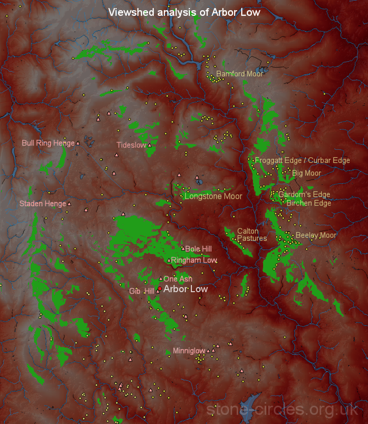 The image to the left shows a viewshed analysis of Arbor Low (click to enlarge). The basemap covers an area measuring 37x43 kilometres (23x27 miles) of the Peak District from Ladybower Reservior in the north to Carsington Water in the south, the site of Arbor Low being marked with the red dot. The areas marked green are land that is theoretically visible to an observer from the site itself while the pink triangles indicate probable Neolithic monuments as proposed by Barnatt and Collis in their study of barrows in the Peak District. The small yellow dots represent other prehistoric sites (mostly of Bronze Age date) taken from both the National Monument Record as well as others included on this website. The image to the left shows a viewshed analysis of Arbor Low (click to enlarge). The basemap covers an area measuring 37x43 kilometres (23x27 miles) of the Peak District from Ladybower Reservior in the north to Carsington Water in the south, the site of Arbor Low being marked with the red dot. The areas marked green are land that is theoretically visible to an observer from the site itself while the pink triangles indicate probable Neolithic monuments as proposed by Barnatt and Collis in their study of barrows in the Peak District. The small yellow dots represent other prehistoric sites (mostly of Bronze Age date) taken from both the National Monument Record as well as others included on this website.There are several caveats to the results however, firstly no account is taken of either present or more importantly, past vegetation cover. It may well be that wooded areas blocked many potential views of other prehistoric sites. Secondly the analysis takes no account of the henge bank which blocks many outwards views that run in a clockwise direction from the northeast round to the southwest. The green areas can be regarded then as representing the viewshed from the site prior to to the construction of the henge, or perhaps just as importantly given the site's role as a regional centre, the view towards Arbor Low from the surrounding landscape with its groups of settlement sites and their associated ritual monuments, the vast majority of which post-date Arbor Low itself. The analysis suggests that several monuments that were either earlier or contemporary with the first phase of Arbor Low, whether that was the stone circle or the henge (pink triangles), would have been intervisible with the site. Particularly noticeable is the arc of Neolithic barrows running north from Gib Hill, taking in One Ash, Ringham Low and Bole Hill. The prominent peak of Minninglow would have been just visible to the southeast with Tideslow way in the distance to the north. Neither of the two other Peak District henges of the Bull Ring or Staden were visible. As for the later monuments, several areas along the eastern gritstone moors that held concentrations of Bronze Age monuments and their associated settlement sites would have had views towards Arbor Low and while it may not have been visible directly given the distances involved, smoke rising from the site during the daytime or firelight at night at a time when modern light pollution was non existent may certainly have been visible. As these areas represent an expansion of the population eastwards onto the gritstone during the early Bronze Age, at a time when a warming climate made these areas viable for pasture and small scale crop cultivation, perhaps the new settlers were keen to maintain the memory and links to their ancestral homeland and its ceremonial centre to the southwest at Arbor Low. Evidence of this link may be seen at a pair of stone circles 10 miles (16km) away to the northeast on Froggatt Edge and at Barbrook I, both of which appear to incorporate alignments towards Arbor Low in their construction.. Additional Notes: The name Arbor Low is though to derive from the Saxon 'Eorthburg Hlaw' or 'Eordburgh Hlaw' simply meaning earthwork mound or hill while another interpretation might relate to the stones themselves with first part of 'Arbor' coming from 'har' meaning grey or hoary. Arbor Low is the only remaining limestone circle in Derbyshire, one was said to previously exist within the Bull Ring henge at Dove Holes just over 10 miles (17km) to the northwest but the stones were removed for building material sometime in the early 18th century. In the early 20th century John Ward uncovered some interesting information in some unpublished records by Samuel Mitchell, regarding the account of some of the stones being still upright in the early 18th century - 'June 1st 1824. Examined Wm. Normanshaw of Middleton, aged 74 years, son of W. Normanshaw mentioned by Pegge. He says he has repeatedly heard his father (who died about 20 years ago at the age of 90) say that he remembered the stones in the circle at Arborlow; many of them standing, more erect than they do now. Does not think they have undergone much alteration in position in his own remembrance.' As Ward points out, if the account is true, then Normanshaw senior implies the remaining stones were leaning rather than fully upright when he was young. Regarding the burial close to the centre of the henge Gray reports that a Dr. J. G. Garson had this to say of the remains - 'the osteological characters show that the individual was not of the type found in interments of the Neolithic period, neither do they point to his being of the Bronze Age type, though he was more nearly allied to it than to the former. On the other hand, there are no characters about the specimen which would preclude its being much more recent'. Although it may be prehistoric, a Roman or Anglo-Saxon intrusive burial is a possibility. A re-examination of the remains using modern forensic methods and dating techniques might settle the question of the skeleton's age once and for all. One of the pottery vessels found by Bateman in the cist within what is presumed to be a Bronze Age barrow on the southern edge of the henge bank is a bit of a conundrum (fourth image on the third row of thumbnails below). It now forms part of the Sheffield Museum collection and was found without a base, its current flat bottom being a plaster reconstruction although it may have originally been round bottomed. Abercromby (1912) gives its height as 11.4 cm (4.5 inches) and compares it to Neolithic pottery forms while Piggott (1931) says it 'appears to be of degenerate Peterborough type', a Neolithic form of pottery that had largely gone out of use by 2500BC and as such it represents a 'Neolithic survival into Bronze Age times'. As the stratigraphy of the site indicates that the barrow forms one of the final phases of construction it might suggest that the vessel was an heirloom piece. However Manby (1957) regards both of the pottery items to be food vessels of Bronze Age date. The holed stone mentioned above in use as a gate-post has now disappeared, possibly ending up a a garden ornament in the Bakewell area. See note by 'stubob' on themodernantiquarian.com website, posted 18th December 2002 Sadly Stu is no longer with us, the Derbyshire section of this website is respectfully dedicated to his memory. |
|
 View looking northwest across the henge ditch and circle from the barrow, the bank is clearly visible behind the stones. The paler grass in the foreground is the spoil from antiquarian excavations of the barrow.. |
|
Slideshow of some of the features of Arbor Low plus some of the finds from the site - click to enlarge. | |
 Rev. Samuel Pegge's plan of Arbor Low (upper left) from 1785 and his elevation drawing below. While neither would win any prizes for accuracy, the elevation, which shows the view looking over the northwest entrance, does at least create a sense of drama, it also shows that the barrow on the distant rim of the henge bank had already been dug into by this date. The plan to the upper right is by Steven Glover, 1829 and is said to be copied from an 'accurate drawing' by Samuel Mitchell. While it is far from accurate it does at least show the earthwork bank or 'avenue' running from near to the southern entrance of the henge, although his depiction of what appears to be two rows of stones lining the southern entrance may be a misinterpretation of fallen or scattered stone fragments. | |
 Plan of Arbor Low that appears in James Ferguson's 'Rude Stone Monuments in all Countries' of 1872. The drawing is credited to Sir Gardner Wilkinson, a noted Egyptologist, and so Ferguson assures us it can be 'thoroughly depended upon'. It is actually quite a good plan which includes the 'avenue' earthwork to the left and detail of the barrow showing that material from the adjacent henge bank was probably robbed for its construction and that previous excavations had left a large crater in the barrow's summit. Gardner also helpfully marks the dimensions one of the cove stones and the largest circle stone, the lengths of which he gives as 4.3m and 3.6m respectively. | |
Panoramas
| |
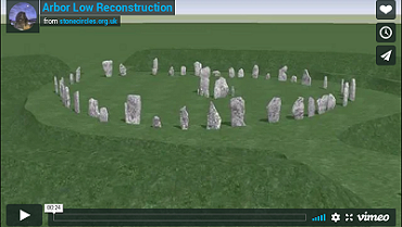
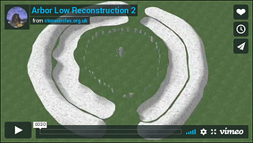
Animations
| |
|
Site Visits / Photographs: Summer 1992, November 2010. References: Abercromby, J. 1912. A study of the Bronze Age pottery of Great Britain & Ireland... Oxford: Clarendon. Andrew, W. 1907. Prehistoric Stone Circles of Derbyshire. In Cox, C. (ed.) Memorials of Old Derbyshire. 70-88. Barham, B. 1928. Arbor Low and the Holed Stone. Derbyshire Archaeological Journal. Vol 50, 79-84. Barnatt, J. 1978. Stone Circles of the Peak. London: Turnstone Books. Barnatt, J. 1987. The Design and Distribution of Stone Circles in Britain... Thesis, (PhD). University of Sheffield. Barnatt, J. and Smith, K. 2004. The Peak District: Landscapes Through Time. Macclesfield: Windgather Press. Bateman, T. 1848. Vestiges of the Antiquities of Derbyshire. London: John Russell Smith. Burl, A. 1976. The Stone Circles of the British Isles. London: Yale University Press. Burl, A. 1995. A Guide to the Stone Circles of Britain, Ireland and Brittany. London: Yale University Press. Burl, A. 1997. Prehistoric Henges. Princes Risborough: Shire Publications Ltd. Barnatt, J. and Collis, J. 1996. Barrows in the Peak District. Recent Research. Sheffield: Collis Publications. Codrington, T. 1919. Roman Roads in Britain. Third Edition. London: Society for promoting Christian knowledge. Cope, J. 1998. The Modern Antiquarian. A Pre-Millennial Odyssey through Megalithic Britain. London: Thorsons. Edmunds, M. and Seaborne, T. 2001. Prehistory in the Peak. Stroud: Tempus. Gibson, A. 2012. An Introduction to the Study of Henges... In: Enclosing the Neolithic... Oxford: Archaeopress. Glover, S. 1829. The History, Gazetteer and Directory of the County of Derby. Derby: Steven Glover. Gray, H. 1904. Arbor Low Stone Circle, excavation in 1901 and 1902. D.A.J., Vol 26, 41-77. Grinsell, L. V. 1936. The Ancient Burial Mounds of England. London: Methuen. Ferguson, J. 1872. Rude Stone Monuments in all Countries; their age and uses. London: Murray. Heathcote, J. C. 1940. Bronze Age Cist from Gib Hill. Derbyshire Archaeological Journal, Vol 61, 66-68. Jewitt, L. 1870. Grave-mounds and their Contents: A Manual of Archaeology. London: Groombridge. Loveday, R. 2004. Contextualising Monuments...of the Middle Trent Valley. D.A.J., Vol 124, 1-12. Manby, T. 1957. Food Vessels of the Peak District. D.A.J., Vol 77, 1-29. McElearney, G. 2007. Digital Archaeology and the Neolithic of the Peak. Thesis, (PhD). University of Sheffield. McGuire, S. and Smith, K. 2008. Arbor Low and Gib Hill Conservation Plan 2008. Peak District N.P.A. Morgan, V. and Morgan, P. 2001. Rock around the Peak. Wilmslow: Sigma Leisure. Pegge, S. 1785. ... the lows or barrows in the Peak District, particularly ... Arbelows. Archaeologia 7, 131-148. Piggott, S. 1931. The Neolithic Pottery of the British Isles. Archaeological Journal, Vol 88, 67-158. Pilkington, J. 1789. A view of the present state of Derbyshire. Vol 2. Derby: Drewry. Radley, J. 1968. The origin of Arbor Low henge monument. D.A.J., Vol 88, 100-103. Thompson, D. 1963. Arbor Low and three other prehistoric sites in Derbyshire. London HMSO. Ward, J. 1908. Notes on some Derbyshire Antiquities from Samuel Mitchell's Memoranda. D.A.J., Vol 30, 155-172. Wilkinson, J. 1860. ..some British Remains in England. Journal Brit. Arch. Assoc., 16, 101-132. Williamson, R. 2012. Timber Circles, Henge Monuments and Stone Circles... Thesis, (MA). University of Bradford. Historic England Research Records Hob Uid: 308656. Scheduled Monument: 11503 / 1011087. National Monuments Record Number: SK 16 SE 8. HER Number: 10108. County Number DR 1. |
|